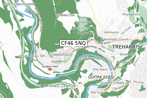
CF46 5NQ is located in the Treharris electoral ward, within the unitary authority of Merthyr Tydfil and the Welsh Parliamentary constituency of Merthyr Tydfil and Rhymney. The Local Health Board is Cwm Taf Morgannwg University and the police force is South Wales. This postcode has been in use since August 2019.


GetTheData
Source: OS Open Zoomstack (Ordnance Survey)
Licence: Open Government Licence (requires attribution)
Attribution: Contains OS data © Crown copyright and database right 2024
Source: Open Postcode Geo
Licence: Open Government Licence (requires attribution)
Attribution: Contains OS data © Crown copyright and database right 2024; Contains Royal Mail data © Royal Mail copyright and database right 2024; Source: Office for National Statistics licensed under the Open Government Licence v.3.0
| Easting | 308998 |
| Northing | 196905 |
| Latitude | 51.663535 |
| Longitude | -3.317140 |
GetTheData
Source: Open Postcode Geo
Licence: Open Government Licence
| Country | Wales |
| Postcode District | CF46 |
➜ See where CF46 is on a map ➜ Where is Treharris? | |
GetTheData
Source: Land Registry Price Paid Data
Licence: Open Government Licence
| Ward | Treharris |
| Constituency | Merthyr Tydfil And Rhymney |
GetTheData
Source: ONS Postcode Database
Licence: Open Government Licence
2021 8 JAN £331,250 |
2020 6 MAR £180,000 |
3, MENLO PARK, EDWARDSVILLE, TREHARRIS, CF46 5NQ 2019 30 AUG £270,000 |
2019 29 AUG £295,000 |
4, MENLO PARK, EDWARDSVILLE, TREHARRIS, CF46 5NQ 2019 23 AUG £295,000 |
GetTheData
Source: HM Land Registry Price Paid Data
Licence: Contains HM Land Registry data © Crown copyright and database right 2024. This data is licensed under the Open Government Licence v3.0.
| Blackbrook (Cardiff Road) | Edwardsville | 172m |
| School (Cardiff Road) | Edwardsville | 193m |
| School (Merthyr Tydfil) | Edwardsville | 196m |
| Blackbrook (Cardiff Road) | Edwardsville | 206m |
| Cardiff Road | Edwardsville | 221m |
| Quakers Yard Station | 0.5km |
| Abercynon Station | 2.2km |
| Merthyr Vale Station | 2.9km |
GetTheData
Source: NaPTAN
Licence: Open Government Licence
GetTheData
Source: ONS Postcode Database
Licence: Open Government Licence


➜ Get more ratings from the Food Standards Agency
GetTheData
Source: Food Standards Agency
Licence: FSA terms & conditions
| Last Collection | |||
|---|---|---|---|
| Location | Mon-Fri | Sat | Distance |
| Cardiff Road Edwardsville | 17:30 | 12:00 | 528m |
| St Winifreds Church | 16:45 | 11:45 | 3,246m |
| Llwyncelyn | 17:15 | 11:00 | 6,405m |
GetTheData
Source: Dracos
Licence: Creative Commons Attribution-ShareAlike
The below table lists the International Territorial Level (ITL) codes (formerly Nomenclature of Territorial Units for Statistics (NUTS) codes) and Local Administrative Units (LAU) codes for CF46 5NQ:
| ITL 1 Code | Name |
|---|---|
| TLL | Wales |
| ITL 2 Code | Name |
| TLL1 | West Wales and The Valleys |
| ITL 3 Code | Name |
| TLL15 | Central Valleys |
| LAU 1 Code | Name |
| W06000024 | Merthyr Tydfil |
GetTheData
Source: ONS Postcode Directory
Licence: Open Government Licence
The below table lists the Census Output Area (OA), Lower Layer Super Output Area (LSOA), and Middle Layer Super Output Area (MSOA) for CF46 5NQ:
| Code | Name | |
|---|---|---|
| OA | W00006924 | |
| LSOA | W01001320 | Merthyr Tydfil 007C |
| MSOA | W02000289 | Merthyr Tydfil 007 |
GetTheData
Source: ONS Postcode Directory
Licence: Open Government Licence
| CF46 5NB | Cardiff Road | 69m |
| CF46 5PH | Ashgrove | 96m |
| CF46 5ND | Rock Villas | 111m |
| CF46 5NL | Nant Ddu Terrace | 112m |
| CF46 5NA | Fernhill Terrace | 117m |
| CF46 5NF | Rock View | 152m |
| CF46 5NG | Forest Grove | 233m |
| CF46 5LY | Blackbrook | 235m |
| CF46 5LS | Pleasant View | 250m |
| CF46 5NW | Beech Grove | 262m |
GetTheData
Source: Open Postcode Geo; Land Registry Price Paid Data
Licence: Open Government Licence