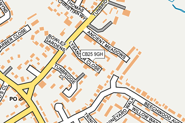
CB25 9GH is located in the Bottisham electoral ward, within the local authority district of East Cambridgeshire and the English Parliamentary constituency of South East Cambridgeshire. The Sub Integrated Care Board (ICB) Location is NHS Cambridgeshire and Peterborough ICB - 06H and the police force is Cambridgeshire. This postcode has been in use since April 2017.


GetTheData
Source: OS OpenMap – Local (Ordnance Survey)
Source: OS VectorMap District (Ordnance Survey)
Licence: Open Government Licence (requires attribution)
| Easting | 554552 |
| Northing | 260884 |
| Latitude | 52.224493 |
| Longitude | 0.261310 |
GetTheData
Source: Open Postcode Geo
Licence: Open Government Licence
| Country | England |
| Postcode District | CB25 |
➜ See where CB25 is on a map ➜ Where is Bottisham? | |
GetTheData
Source: Land Registry Price Paid Data
Licence: Open Government Licence
| Ward | Bottisham |
| Constituency | South East Cambridgeshire |
GetTheData
Source: ONS Postcode Database
Licence: Open Government Licence
2024 28 JUN £545,000 |
20, LYSANDER CLOSE, BOTTISHAM, CAMBRIDGE, CB25 9GH 2017 30 JUN £530,000 |
19, LYSANDER CLOSE, BOTTISHAM, CAMBRIDGE, CB25 9GH 2017 30 JUN £549,995 |
22, LYSANDER CLOSE, BOTTISHAM, CAMBRIDGE, CB25 9GH 2017 27 JUN £569,995 |
23, LYSANDER CLOSE, BOTTISHAM, CAMBRIDGE, CB25 9GH 2017 2 JUN £519,995 |
1, LYSANDER CLOSE, BOTTISHAM, CAMBRIDGE, CB25 9GH 2017 31 MAY £400,000 |
24, LYSANDER CLOSE, BOTTISHAM, CAMBRIDGE, CB25 9GH 2017 30 MAY £404,995 |
2017 30 MAY £399,995 |
5, LYSANDER CLOSE, BOTTISHAM, CAMBRIDGE, CB25 9GH 2017 30 MAY £529,995 |
6, LYSANDER CLOSE, BOTTISHAM, CAMBRIDGE, CB25 9GH 2017 30 MAY £449,995 |
GetTheData
Source: HM Land Registry Price Paid Data
Licence: Contains HM Land Registry data © Crown copyright and database right 2024. This data is licensed under the Open Government Licence v3.0.
| The Pightle (Tunbridge Lane) | Bottisham | 156m |
| The Pightle (Tunbridge Lane) | Bottisham | 157m |
| Bell Road (High Street) | Bottisham | 251m |
| Bell Road (High Street) | Bottisham | 260m |
| Stocks Close (High Street) | Bottisham | 410m |
| Waterbeach Station | 6.1km |
GetTheData
Source: NaPTAN
Licence: Open Government Licence
| Percentage of properties with Next Generation Access | 100.0% |
| Percentage of properties with Superfast Broadband | 100.0% |
| Percentage of properties with Ultrafast Broadband | 100.0% |
| Percentage of properties with Full Fibre Broadband | 100.0% |
Superfast Broadband is between 30Mbps and 300Mbps
Ultrafast Broadband is > 300Mbps
| Percentage of properties unable to receive 2Mbps | 0.0% |
| Percentage of properties unable to receive 5Mbps | 0.0% |
| Percentage of properties unable to receive 10Mbps | 0.0% |
| Percentage of properties unable to receive 30Mbps | 0.0% |
GetTheData
Source: Ofcom
Licence: Ofcom Terms of Use (requires attribution)
GetTheData
Source: ONS Postcode Database
Licence: Open Government Licence


➜ Get more ratings from the Food Standards Agency
GetTheData
Source: Food Standards Agency
Licence: FSA terms & conditions
| Last Collection | |||
|---|---|---|---|
| Location | Mon-Fri | Sat | Distance |
| Bottisham Post Office | 17:15 | 11:15 | 246m |
| High Street,bottisham | 16:45 | 11:00 | 587m |
| Lode Road | 17:00 | 11:00 | 613m |
GetTheData
Source: Dracos
Licence: Creative Commons Attribution-ShareAlike
The below table lists the International Territorial Level (ITL) codes (formerly Nomenclature of Territorial Units for Statistics (NUTS) codes) and Local Administrative Units (LAU) codes for CB25 9GH:
| ITL 1 Code | Name |
|---|---|
| TLH | East |
| ITL 2 Code | Name |
| TLH1 | East Anglia |
| ITL 3 Code | Name |
| TLH12 | Cambridgeshire CC |
| LAU 1 Code | Name |
| E07000009 | East Cambridgeshire |
GetTheData
Source: ONS Postcode Directory
Licence: Open Government Licence
The below table lists the Census Output Area (OA), Lower Layer Super Output Area (LSOA), and Middle Layer Super Output Area (MSOA) for CB25 9GH:
| Code | Name | |
|---|---|---|
| OA | E00090853 | |
| LSOA | E01018012 | East Cambridgeshire 009B |
| MSOA | E02003740 | East Cambridgeshire 009 |
GetTheData
Source: ONS Postcode Directory
Licence: Open Government Licence
| CB25 9AX | Ancient Meadows | 72m |
| CB25 9BW | Mulberry Close | 74m |
| CB25 9DU | Tunbridge Lane | 95m |
| CB25 9EB | Tunbridge Close | 108m |
| CB25 9BP | Vineyard Walk | 174m |
| CB25 9TA | Rowley Gardens | 180m |
| CB25 9DB | Beechwood Avenue | 185m |
| CB25 9DG | The Pightle | 199m |
| CB25 9DX | Thomas Christian Way | 203m |
| CB25 9DE | Trinity Close | 230m |
GetTheData
Source: Open Postcode Geo; Land Registry Price Paid Data
Licence: Open Government Licence