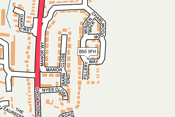
BN5 9FH is located in the Henfield electoral ward, within the local authority district of Horsham and the English Parliamentary constituency of Arundel and South Downs. The Sub Integrated Care Board (ICB) Location is NHS Sussex ICB - 70F and the police force is Sussex. This postcode has been in use since July 2017.


GetTheData
Source: OS OpenMap – Local (Ordnance Survey)
Source: OS VectorMap District (Ordnance Survey)
Licence: Open Government Licence (requires attribution)
| Easting | 521683 |
| Northing | 116417 |
| Latitude | 50.934368 |
| Longitude | -0.269657 |
GetTheData
Source: Open Postcode Geo
Licence: Open Government Licence
| Country | England |
| Postcode District | BN5 |
➜ See where BN5 is on a map ➜ Where is Henfield? | |
GetTheData
Source: Land Registry Price Paid Data
Licence: Open Government Licence
| Ward | Henfield |
| Constituency | Arundel And South Downs |
GetTheData
Source: ONS Postcode Database
Licence: Open Government Licence
2022 19 OCT £740,000 |
2021 25 FEB £525,000 |
17, FILLERY WAY, HENFIELD, BN5 9FH 2017 14 DEC £434,950 |
15, FILLERY WAY, HENFIELD, BN5 9FH 2017 11 DEC £434,950 |
23, FILLERY WAY, HENFIELD, BN5 9FH 2017 5 DEC £435,000 |
27, FILLERY WAY, HENFIELD, BN5 9FH 2017 23 NOV £434,950 |
2017 20 OCT £499,950 |
2017 16 OCT £429,950 |
2, FILLERY WAY, HENFIELD, BN5 9FH 2017 5 SEP £499,950 |
12, FILLERY WAY, HENFIELD, BN5 9FH 2017 18 AUG £499,950 |
GetTheData
Source: HM Land Registry Price Paid Data
Licence: Contains HM Land Registry data © Crown copyright and database right 2024. This data is licensed under the Open Government Licence v3.0.
| Manor Way (London Road) | Henfield | 181m |
| Manor Way (London Road) | Henfield | 196m |
| London Road (Parsonage Road) | Henfield | 238m |
| London Road (Parsonage Road) | Henfield | 238m |
| Furners Lane (London Road) | Henfield | 247m |
GetTheData
Source: NaPTAN
Licence: Open Government Licence
| Percentage of properties with Next Generation Access | 100.0% |
| Percentage of properties with Superfast Broadband | 100.0% |
| Percentage of properties with Ultrafast Broadband | 100.0% |
| Percentage of properties with Full Fibre Broadband | 100.0% |
Superfast Broadband is between 30Mbps and 300Mbps
Ultrafast Broadband is > 300Mbps
| Median download speed | 16.3Mbps |
| Average download speed | 15.3Mbps |
| Maximum download speed | 20.12Mbps |
| Median upload speed | 1.1Mbps |
| Average upload speed | 1.0Mbps |
| Maximum upload speed | 1.23Mbps |
| Percentage of properties unable to receive 2Mbps | 0.0% |
| Percentage of properties unable to receive 5Mbps | 0.0% |
| Percentage of properties unable to receive 10Mbps | 0.0% |
| Percentage of properties unable to receive 30Mbps | 0.0% |
GetTheData
Source: Ofcom
Licence: Ofcom Terms of Use (requires attribution)
GetTheData
Source: ONS Postcode Database
Licence: Open Government Licence


➜ Get more ratings from the Food Standards Agency
GetTheData
Source: Food Standards Agency
Licence: FSA terms & conditions
| Last Collection | |||
|---|---|---|---|
| Location | Mon-Fri | Sat | Distance |
| Bines Green | 16:00 | 08:30 | 3,260m |
| Fountain (Ashurst) | 16:45 | 09:00 | 3,724m |
| Horsebridge Common | 16:30 | 09:00 | 3,985m |
GetTheData
Source: Dracos
Licence: Creative Commons Attribution-ShareAlike
The below table lists the International Territorial Level (ITL) codes (formerly Nomenclature of Territorial Units for Statistics (NUTS) codes) and Local Administrative Units (LAU) codes for BN5 9FH:
| ITL 1 Code | Name |
|---|---|
| TLJ | South East (England) |
| ITL 2 Code | Name |
| TLJ2 | Surrey, East and West Sussex |
| ITL 3 Code | Name |
| TLJ28 | West Sussex (North East) |
| LAU 1 Code | Name |
| E07000227 | Horsham |
GetTheData
Source: ONS Postcode Directory
Licence: Open Government Licence
The below table lists the Census Output Area (OA), Lower Layer Super Output Area (LSOA), and Middle Layer Super Output Area (MSOA) for BN5 9FH:
| Code | Name | |
|---|---|---|
| OA | E00161364 | |
| LSOA | E01031642 | Horsham 014C |
| MSOA | E02006601 | Horsham 014 |
GetTheData
Source: ONS Postcode Directory
Licence: Open Government Licence
| BN5 9LD | Barn End | 80m |
| BN5 9LB | Manor Close | 114m |
| BN5 9JZ | Nyes Close | 131m |
| BN5 9LA | Manor Way | 165m |
| BN5 9JL | London Road | 179m |
| BN5 9HY | Benson Road | 208m |
| BN5 9JH | London Road | 234m |
| BN5 9JJ | London Road | 246m |
| BN5 9JU | Wantley Hill Estate | 256m |
| BN5 9HL | Furners Mead | 261m |
GetTheData
Source: Open Postcode Geo; Land Registry Price Paid Data
Licence: Open Government Licence