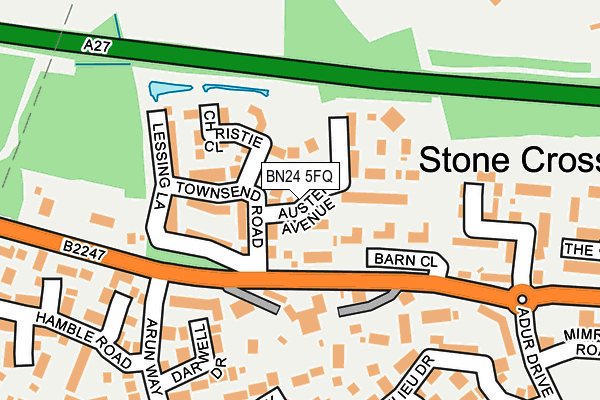
BN24 5FQ is located in the Polegate Central electoral ward, within the local authority district of Wealden and the English Parliamentary constituency of Bexhill and Battle. The Sub Integrated Care Board (ICB) Location is NHS Sussex ICB - 97R and the police force is Sussex. This postcode has been in use since May 2017.


GetTheData
Source: OS OpenMap – Local (Ordnance Survey)
Source: OS VectorMap District (Ordnance Survey)
Licence: Open Government Licence (requires attribution)
| Easting | 561184 |
| Northing | 104544 |
| Latitude | 50.818010 |
| Longitude | 0.286840 |
GetTheData
Source: Open Postcode Geo
Licence: Open Government Licence
| Country | England |
| Postcode District | BN24 |
➜ See where BN24 is on a map ➜ Where is Stone Cross? | |
GetTheData
Source: Land Registry Price Paid Data
Licence: Open Government Licence
| Ward | Polegate Central |
| Constituency | Bexhill And Battle |
GetTheData
Source: ONS Postcode Database
Licence: Open Government Licence
2022 17 AUG £492,000 |
2020 16 DEC £489,950 |
20, AUSTEN AVENUE, STONE CROSS, PEVENSEY, BN24 5FQ 2018 25 MAY £438,000 |
15, AUSTEN AVENUE, STONE CROSS, PEVENSEY, BN24 5FQ 2018 4 MAY £444,995 |
13, AUSTEN AVENUE, STONE CROSS, PEVENSEY, BN24 5FQ 2018 4 MAY £378,500 |
18, AUSTEN AVENUE, STONE CROSS, PEVENSEY, BN24 5FQ 2018 13 APR £371,000 |
16, AUSTEN AVENUE, STONE CROSS, PEVENSEY, BN24 5FQ 2018 19 MAR £372,000 |
2018 2 MAR £372,000 |
12, AUSTEN AVENUE, STONE CROSS, PEVENSEY, BN24 5FQ 2018 23 FEB £367,995 |
10, AUSTEN AVENUE, STONE CROSS, PEVENSEY, BN24 5FQ 2018 2 FEB £439,995 |
GetTheData
Source: HM Land Registry Price Paid Data
Licence: Contains HM Land Registry data © Crown copyright and database right 2024. This data is licensed under the Open Government Licence v3.0.
| Arun Way (Dittons Road) | Stone Cross | 253m |
| Arun Way (Dittons Road) | Stone Cross | 258m |
| The Crossways (Dittons Road) | Stone Cross | 262m |
| The Crossways (Dittons Road) | Stone Cross | 289m |
| Primary School (Adur Drive) | Stone Cross | 313m |
| Hampden Park (Sussex) Station | 2.5km |
| Pevensey & Westham Station | 2.7km |
| Polegate Station | 3km |
GetTheData
Source: NaPTAN
Licence: Open Government Licence
| Percentage of properties with Next Generation Access | 100.0% |
| Percentage of properties with Superfast Broadband | 100.0% |
| Percentage of properties with Ultrafast Broadband | 100.0% |
| Percentage of properties with Full Fibre Broadband | 100.0% |
Superfast Broadband is between 30Mbps and 300Mbps
Ultrafast Broadband is > 300Mbps
| Percentage of properties unable to receive 2Mbps | 0.0% |
| Percentage of properties unable to receive 5Mbps | 0.0% |
| Percentage of properties unable to receive 10Mbps | 0.0% |
| Percentage of properties unable to receive 30Mbps | 0.0% |
GetTheData
Source: Ofcom
Licence: Ofcom Terms of Use (requires attribution)
GetTheData
Source: ONS Postcode Database
Licence: Open Government Licence


➜ Get more ratings from the Food Standards Agency
GetTheData
Source: Food Standards Agency
Licence: FSA terms & conditions
| Last Collection | |||
|---|---|---|---|
| Location | Mon-Fri | Sat | Distance |
| Arun Way | 16:00 | 11:00 | 248m |
| Adur Drive | 16:00 | 11:00 | 250m |
| Milton Place | 16:00 | 11:00 | 386m |
GetTheData
Source: Dracos
Licence: Creative Commons Attribution-ShareAlike
The below table lists the International Territorial Level (ITL) codes (formerly Nomenclature of Territorial Units for Statistics (NUTS) codes) and Local Administrative Units (LAU) codes for BN24 5FQ:
| ITL 1 Code | Name |
|---|---|
| TLJ | South East (England) |
| ITL 2 Code | Name |
| TLJ2 | Surrey, East and West Sussex |
| ITL 3 Code | Name |
| TLJ22 | East Sussex CC |
| LAU 1 Code | Name |
| E07000065 | Wealden |
GetTheData
Source: ONS Postcode Directory
Licence: Open Government Licence
The below table lists the Census Output Area (OA), Lower Layer Super Output Area (LSOA), and Middle Layer Super Output Area (MSOA) for BN24 5FQ:
| Code | Name | |
|---|---|---|
| OA | E00107739 | |
| LSOA | E01021208 | Wealden 020C |
| MSOA | E02004422 | Wealden 020 |
GetTheData
Source: ONS Postcode Directory
Licence: Open Government Licence
| BN24 5EU | St Michaels Close | 126m |
| BN24 5ER | Dittons Road | 131m |
| BN24 5DN | Beaulieu Drive | 172m |
| BN24 5EL | Dittons Road | 193m |
| BN24 5PH | Medway Lane | 221m |
| BN24 5PG | Darwell Drive | 236m |
| BN24 5EP | Dittons Road | 237m |
| BN24 5EW | Beaulieu Drive | 237m |
| BN24 5EJ | The Crossways | 242m |
| BN24 5EH | The Crossways | 251m |
GetTheData
Source: Open Postcode Geo; Land Registry Price Paid Data
Licence: Open Government Licence