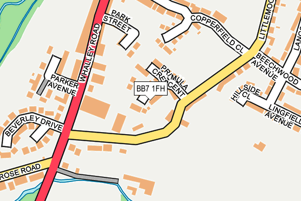
BB7 1FH is located in the Littlemoor electoral ward, within the local authority district of Ribble Valley and the English Parliamentary constituency of Ribble Valley. The Sub Integrated Care Board (ICB) Location is NHS Lancashire and South Cumbria ICB - 01A and the police force is Lancashire. This postcode has been in use since February 2017.


GetTheData
Source: OS OpenMap – Local (Ordnance Survey)
Source: OS VectorMap District (Ordnance Survey)
Licence: Open Government Licence (requires attribution)
| Easting | 374218 |
| Northing | 440849 |
| Latitude | 53.863226 |
| Longitude | -2.393511 |
GetTheData
Source: Open Postcode Geo
Licence: Open Government Licence
| Country | England |
| Postcode District | BB7 |
➜ See where BB7 is on a map ➜ Where is Clitheroe? | |
GetTheData
Source: Land Registry Price Paid Data
Licence: Open Government Licence
| Ward | Littlemoor |
| Constituency | Ribble Valley |
GetTheData
Source: ONS Postcode Database
Licence: Open Government Licence
2024 18 OCT £415,000 |
6, SUNDROP CLOSE, CLITHEROE, BB7 1FH 2017 13 OCT £324,950 |
2, SUNDROP CLOSE, CLITHEROE, BB7 1FH 2017 30 JUN £329,975 |
11, SUNDROP CLOSE, CLITHEROE, BB7 1FH 2017 5 MAY £345,000 |
7, SUNDROP CLOSE, CLITHEROE, BB7 1FH 2017 21 APR £340,000 |
5, SUNDROP CLOSE, CLITHEROE, BB7 1FH 2017 21 APR £329,950 |
8, SUNDROP CLOSE, CLITHEROE, BB7 1FH 2017 20 APR £345,000 |
4, SUNDROP CLOSE, CLITHEROE, BB7 1FH 2017 13 APR £329,950 |
9, SUNDROP CLOSE, CLITHEROE, BB7 1FH 2017 13 APR £332,500 |
1, SUNDROP CLOSE, CLITHEROE, BB7 1FH 2017 12 APR £289,950 |
GetTheData
Source: HM Land Registry Price Paid Data
Licence: Contains HM Land Registry data © Crown copyright and database right 2025. This data is licensed under the Open Government Licence v3.0.
| Littlemoor Road (Whalley Road) | Primrose | 151m |
| Littlemooor Road (Whalley Road) | Primrose | 156m |
| Park Street (Whalley Road) | Primrose | 191m |
| Park Street (Whalley Road) | Primrose | 200m |
| Langshaw Drive | Little Moor | 295m |
| Clitheroe Station | 1.1km |
| Whalley Station | 4.5km |
GetTheData
Source: NaPTAN
Licence: Open Government Licence
| Percentage of properties with Next Generation Access | 100.0% |
| Percentage of properties with Superfast Broadband | 100.0% |
| Percentage of properties with Ultrafast Broadband | 0.0% |
| Percentage of properties with Full Fibre Broadband | 0.0% |
Superfast Broadband is between 30Mbps and 300Mbps
Ultrafast Broadband is > 300Mbps
| Median download speed | 50.0Mbps |
| Average download speed | 45.7Mbps |
| Maximum download speed | 70.24Mbps |
| Median upload speed | 10.0Mbps |
| Average upload speed | 10.0Mbps |
| Maximum upload speed | 20.00Mbps |
| Percentage of properties unable to receive 2Mbps | 0.0% |
| Percentage of properties unable to receive 5Mbps | 0.0% |
| Percentage of properties unable to receive 10Mbps | 0.0% |
| Percentage of properties unable to receive 30Mbps | 0.0% |
GetTheData
Source: Ofcom
Licence: Ofcom Terms of Use (requires attribution)
GetTheData
Source: ONS Postcode Database
Licence: Open Government Licence


➜ Get more ratings from the Food Standards Agency
GetTheData
Source: Food Standards Agency
Licence: FSA terms & conditions
| Last Collection | |||
|---|---|---|---|
| Location | Mon-Fri | Sat | Distance |
| 2 Beverley Drive | 17:00 | 11:00 | 181m |
| 144 Chatburn Road | 16:00 | 11:30 | 1,908m |
| Station Whalley | 16:15 | 12:30 | 4,572m |
GetTheData
Source: Dracos
Licence: Creative Commons Attribution-ShareAlike
The below table lists the International Territorial Level (ITL) codes (formerly Nomenclature of Territorial Units for Statistics (NUTS) codes) and Local Administrative Units (LAU) codes for BB7 1FH:
| ITL 1 Code | Name |
|---|---|
| TLD | North West (England) |
| ITL 2 Code | Name |
| TLD4 | Lancashire |
| ITL 3 Code | Name |
| TLD45 | Mid Lancashire |
| LAU 1 Code | Name |
| E07000124 | Ribble Valley |
GetTheData
Source: ONS Postcode Directory
Licence: Open Government Licence
The below table lists the Census Output Area (OA), Lower Layer Super Output Area (LSOA), and Middle Layer Super Output Area (MSOA) for BB7 1FH:
| Code | Name | |
|---|---|---|
| OA | E00128579 | |
| LSOA | E01025334 | Ribble Valley 002A |
| MSOA | E02005271 | Ribble Valley 002 |
GetTheData
Source: ONS Postcode Directory
Licence: Open Government Licence
| BB7 1HF | Littlemoor | 59m |
| BB7 1HS | Littlemoor View | 132m |
| BB7 1HT | Whalley Road | 159m |
| BB7 1HR | Park Street | 163m |
| BB7 1ER | Copperfield Close | 180m |
| BB7 1JA | Parker Avenue | 190m |
| BB7 1HB | Hillside Close | 197m |
| BB7 1HW | Whalley Road | 208m |
| BB7 1HX | Beverley Close | 238m |
| BB7 1HJ | Hall Street | 266m |
GetTheData
Source: Open Postcode Geo; Land Registry Price Paid Data
Licence: Open Government Licence