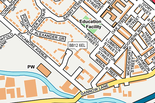
BB12 6EL is located in the Rosegrove with Lowerhouse electoral ward, within the local authority district of Burnley and the English Parliamentary constituency of Burnley. The Sub Integrated Care Board (ICB) Location is NHS Lancashire and South Cumbria ICB - 01A and the police force is Lancashire. This postcode has been in use since March 2017.


GetTheData
Source: OS OpenMap – Local (Ordnance Survey)
Source: OS VectorMap District (Ordnance Survey)
Licence: Open Government Licence (requires attribution)
| Easting | 381694 |
| Northing | 432782 |
| Latitude | 53.791041 |
| Longitude | -2.279353 |
GetTheData
Source: Open Postcode Geo
Licence: Open Government Licence
| Country | England |
| Postcode District | BB12 |
➜ See where BB12 is on a map ➜ Where is Burnley? | |
GetTheData
Source: Land Registry Price Paid Data
Licence: Open Government Licence
| Ward | Rosegrove With Lowerhouse |
| Constituency | Burnley |
GetTheData
Source: ONS Postcode Database
Licence: Open Government Licence
2024 19 DEC £210,000 |
2022 11 NOV £270,000 |
2022 11 NOV £230,000 |
2020 21 DEC £232,000 |
2019 11 DEC £179,950 |
2, MADEN FOLD BANK, BURNLEY, BB12 6EL 2019 25 JUN £239,995 |
2019 13 JUN £229,995 |
51, MADEN FOLD BANK, BURNLEY, BB12 6EL 2018 10 OCT £169,995 |
24, MADEN FOLD BANK, BURNLEY, BB12 6EL 2018 8 OCT £175,995 |
22, MADEN FOLD BANK, BURNLEY, BB12 6EL 2018 30 AUG £181,995 |
GetTheData
Source: HM Land Registry Price Paid Data
Licence: Contains HM Land Registry data © Crown copyright and database right 2025. This data is licensed under the Open Government Licence v3.0.
| St Augustines Church (Lowerhouse Lane) | Rose Grove | 161m |
| St Augustines Church (Lowerhouse Lane) | Rose Grove | 201m |
| White Street (Gannow Lane) | Rose Grove | 203m |
| Tedder Avenue (Sycamore Avenue) | Rose Grove | 212m |
| Dorset Street (Lowerhouse Lane) | Rose Grove | 218m |
| Rose Grove Station | 0.6km |
| Burnley Barracks Station | 1.4km |
| Burnley Manchester Road Station | 2.1km |
GetTheData
Source: NaPTAN
Licence: Open Government Licence
| Percentage of properties with Next Generation Access | 100.0% |
| Percentage of properties with Superfast Broadband | 100.0% |
| Percentage of properties with Ultrafast Broadband | 0.0% |
| Percentage of properties with Full Fibre Broadband | 0.0% |
Superfast Broadband is between 30Mbps and 300Mbps
Ultrafast Broadband is > 300Mbps
| Median download speed | 39.1Mbps |
| Average download speed | 41.7Mbps |
| Maximum download speed | 67.37Mbps |
| Median upload speed | 9.7Mbps |
| Average upload speed | 9.0Mbps |
| Maximum upload speed | 19.53Mbps |
| Percentage of properties unable to receive 2Mbps | 0.0% |
| Percentage of properties unable to receive 5Mbps | 0.0% |
| Percentage of properties unable to receive 10Mbps | 0.0% |
| Percentage of properties unable to receive 30Mbps | 0.0% |
GetTheData
Source: Ofcom
Licence: Ofcom Terms of Use (requires attribution)
GetTheData
Source: ONS Postcode Database
Licence: Open Government Licence


➜ Get more ratings from the Food Standards Agency
GetTheData
Source: Food Standards Agency
Licence: FSA terms & conditions
| Last Collection | |||
|---|---|---|---|
| Location | Mon-Fri | Sat | Distance |
| 81 Rosegrove Lane | 16:00 | 11:00 | 440m |
| Padiham Bridge | 17:30 | 11:00 | 761m |
| Farrington Road | 18:00 | 11:00 | 1,084m |
GetTheData
Source: Dracos
Licence: Creative Commons Attribution-ShareAlike
The below table lists the International Territorial Level (ITL) codes (formerly Nomenclature of Territorial Units for Statistics (NUTS) codes) and Local Administrative Units (LAU) codes for BB12 6EL:
| ITL 1 Code | Name |
|---|---|
| TLD | North West (England) |
| ITL 2 Code | Name |
| TLD4 | Lancashire |
| ITL 3 Code | Name |
| TLD46 | East Lancashire |
| LAU 1 Code | Name |
| E07000117 | Burnley |
GetTheData
Source: ONS Postcode Directory
Licence: Open Government Licence
The below table lists the Census Output Area (OA), Lower Layer Super Output Area (LSOA), and Middle Layer Super Output Area (MSOA) for BB12 6EL:
| Code | Name | |
|---|---|---|
| OA | E00126379 | |
| LSOA | E01024902 | Burnley 006C |
| MSOA | E02005181 | Burnley 006 |
GetTheData
Source: ONS Postcode Directory
Licence: Open Government Licence
| BB12 6JU | Wilson Fold | 85m |
| BB12 6JH | Snowden Street | 137m |
| BB12 6JQ | White Street | 143m |
| BB12 6AH | Lockyer Avenue | 144m |
| BB12 6HZ | Lowerhouse Lane | 175m |
| BB12 6JG | Harling Street | 177m |
| BB12 6HU | Lowerhouse Lane | 209m |
| BB12 6HY | Gannow Lane | 212m |
| BB12 6DQ | Sycamore Avenue | 219m |
| BB12 6AN | Rutland Avenue | 232m |
GetTheData
Source: Open Postcode Geo; Land Registry Price Paid Data
Licence: Open Government Licence