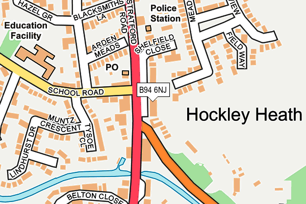
B94 6NJ lies on Stratford Road in Hockley Heath, Solihull. B94 6NJ is located in the Dorridge and Hockley Heath electoral ward, within the metropolitan district of Solihull and the English Parliamentary constituency of Meriden. The Sub Integrated Care Board (ICB) Location is NHS Birmingham and Solihull ICB - 15E and the police force is West Midlands. This postcode has been in use since January 1980.


GetTheData
Source: OS OpenMap – Local (Ordnance Survey)
Source: OS VectorMap District (Ordnance Survey)
Licence: Open Government Licence (requires attribution)
| Easting | 415296 |
| Northing | 272637 |
| Latitude | 52.351590 |
| Longitude | -1.776857 |
GetTheData
Source: Open Postcode Geo
Licence: Open Government Licence
| Street | Stratford Road |
| Locality | Hockley Heath |
| Town/City | Solihull |
| Country | England |
| Postcode District | B94 |
➜ See where B94 is on a map ➜ Where is Hockley Heath? | |
GetTheData
Source: Land Registry Price Paid Data
Licence: Open Government Licence
Elevation or altitude of B94 6NJ as distance above sea level:
| Metres | Feet | |
|---|---|---|
| Elevation | 140m | 459ft |
Elevation is measured from the approximate centre of the postcode, to the nearest point on an OS contour line from OS Terrain 50, which has contour spacing of ten vertical metres.
➜ How high above sea level am I? Find the elevation of your current position using your device's GPS.
GetTheData
Source: Open Postcode Elevation
Licence: Open Government Licence
| Ward | Dorridge And Hockley Heath |
| Constituency | Meriden |
GetTheData
Source: ONS Postcode Database
Licence: Open Government Licence
2021 30 NOV £540,000 |
2002 4 OCT £207,500 |
2002 22 JUL £249,950 |
2001 22 MAR £230,000 |
GetTheData
Source: HM Land Registry Price Paid Data
Licence: Contains HM Land Registry data © Crown copyright and database right 2025. This data is licensed under the Open Government Licence v3.0.
| The Wharf (Stratford Rd) | Hockley Heath | 30m |
| The Wharf (Stratford Rd) | Hockley Heath | 58m |
| Aylesbury Rd (Stratford Rd) | Hockley Heath | 225m |
| Aylesbury Rd | Hockley Heath | 257m |
| Aylesbury Rd (Stratford Rd) | Hockley Heath | 366m |
| Dorridge Station | 2.8km |
| Lapworth Station | 3.6km |
| Danzey Station | 4.2km |
GetTheData
Source: NaPTAN
Licence: Open Government Licence
| Percentage of properties with Next Generation Access | 100.0% |
| Percentage of properties with Superfast Broadband | 100.0% |
| Percentage of properties with Ultrafast Broadband | 0.0% |
| Percentage of properties with Full Fibre Broadband | 0.0% |
Superfast Broadband is between 30Mbps and 300Mbps
Ultrafast Broadband is > 300Mbps
| Percentage of properties unable to receive 2Mbps | 0.0% |
| Percentage of properties unable to receive 5Mbps | 0.0% |
| Percentage of properties unable to receive 10Mbps | 0.0% |
| Percentage of properties unable to receive 30Mbps | 0.0% |
GetTheData
Source: Ofcom
Licence: Ofcom Terms of Use (requires attribution)
GetTheData
Source: ONS Postcode Database
Licence: Open Government Licence


➜ Get more ratings from the Food Standards Agency
GetTheData
Source: Food Standards Agency
Licence: FSA terms & conditions
| Last Collection | |||
|---|---|---|---|
| Location | Mon-Fri | Sat | Distance |
| 40 Spring Lane | 09:00 | 09:00 | 347m |
| Near 77 Aylesbury Road | 16:00 | 09:30 | 484m |
| Old Warwick Road | 17:00 | 07:00 | 1,592m |
GetTheData
Source: Dracos
Licence: Creative Commons Attribution-ShareAlike
The below table lists the International Territorial Level (ITL) codes (formerly Nomenclature of Territorial Units for Statistics (NUTS) codes) and Local Administrative Units (LAU) codes for B94 6NJ:
| ITL 1 Code | Name |
|---|---|
| TLG | West Midlands (England) |
| ITL 2 Code | Name |
| TLG3 | West Midlands |
| ITL 3 Code | Name |
| TLG32 | Solihull |
| LAU 1 Code | Name |
| E08000029 | Solihull |
GetTheData
Source: ONS Postcode Directory
Licence: Open Government Licence
The below table lists the Census Output Area (OA), Lower Layer Super Output Area (LSOA), and Middle Layer Super Output Area (MSOA) for B94 6NJ:
| Code | Name | |
|---|---|---|
| OA | E00051504 | |
| LSOA | E01010189 | Solihull 029E |
| MSOA | E02002109 | Solihull 029 |
GetTheData
Source: ONS Postcode Directory
Licence: Open Government Licence
| B94 6HH | Old Warwick Road | 72m |
| B94 6QT | Stratford Road | 82m |
| B94 6PG | Meadow Close | 109m |
| B94 6NL | Stratford Road | 112m |
| B94 6QN | Arden Meads | 124m |
| B94 6NG | Shelfield Close | 148m |
| B94 6QG | Tysoe Close | 158m |
| B94 6QL | Orchard Road | 173m |
| B94 6PQ | Field Way | 180m |
| B94 6QP | Blacksmiths Lane | 190m |
GetTheData
Source: Open Postcode Geo; Land Registry Price Paid Data
Licence: Open Government Licence