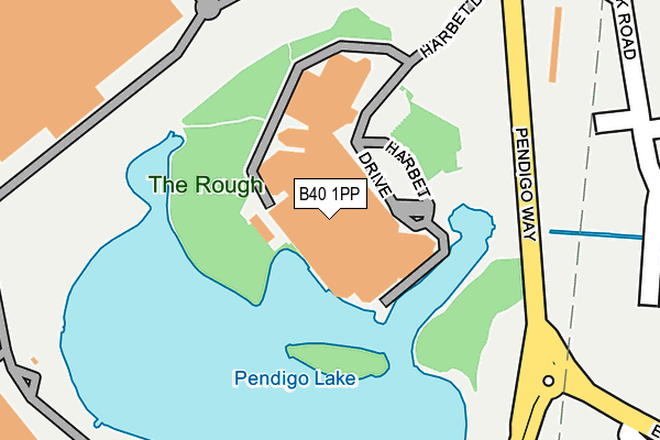
B40 1PP is located in the Bickenhill electoral ward, within the metropolitan district of Solihull and the English Parliamentary constituency of Meriden. The Sub Integrated Care Board (ICB) Location is NHS Birmingham and Solihull ICB - 15E and the police force is West Midlands. This postcode has been in use since January 1980.


GetTheData
Source: OS OpenMap – Local (Ordnance Survey)
Source: OS VectorMap District (Ordnance Survey)
Licence: Open Government Licence (requires attribution)
| Easting | 419417 |
| Northing | 283647 |
| Latitude | 52.450440 |
| Longitude | -1.715721 |
GetTheData
Source: Open Postcode Geo
Licence: Open Government Licence
| Country | England |
| Postcode District | B40 |
➜ See where B40 is on a map ➜ Where is Birmingham? | |
GetTheData
Source: Land Registry Price Paid Data
Licence: Open Government Licence
Elevation or altitude of B40 1PP as distance above sea level:
| Metres | Feet | |
|---|---|---|
| Elevation | 90m | 295ft |
Elevation is measured from the approximate centre of the postcode, to the nearest point on an OS contour line from OS Terrain 50, which has contour spacing of ten vertical metres.
➜ How high above sea level am I? Find the elevation of your current position using your device's GPS.
GetTheData
Source: Open Postcode Elevation
Licence: Open Government Licence
| Ward | Bickenhill |
| Constituency | Meriden |
GetTheData
Source: ONS Postcode Database
Licence: Open Government Licence
| Resorts World (Pendigo Way) | Stonebridge | 396m |
| Resorts World (Pendigo Way) | Stonebridge | 408m |
| Trinity Park (Station Way (Nec Grounds)) | National Exhibition Centre | 547m |
| Trinity Park (Station Way (Nec Grounds)) | National Exhibition Centre | 613m |
| Church Lane (Coventry Rd) | Bickenhill | 662m |
| Birmingham Intl Rail Station (Air-rail Link) | Birmingham Airport | 710m |
| Birmingham International Airport (Air-rail Link) | Birmingham Airport | 1,162m |
| Birmingham International Station | 0.7km |
| Hampton-in-Arden Station | 2.6km |
| Marston Green Station | 3.3km |
GetTheData
Source: NaPTAN
Licence: Open Government Licence
GetTheData
Source: ONS Postcode Database
Licence: Open Government Licence


➜ Get more ratings from the Food Standards Agency
GetTheData
Source: Food Standards Agency
Licence: FSA terms & conditions
| Last Collection | |||
|---|---|---|---|
| Location | Mon-Fri | Sat | Distance |
| Bham Intl Station | 17:00 | 12:00 | 643m |
| Bickenhill Road / Blackfirs Lane | 17:15 | 12:00 | 1,730m |
| Elmdon Trading Estate | 1,881m | ||
GetTheData
Source: Dracos
Licence: Creative Commons Attribution-ShareAlike
The below table lists the International Territorial Level (ITL) codes (formerly Nomenclature of Territorial Units for Statistics (NUTS) codes) and Local Administrative Units (LAU) codes for B40 1PP:
| ITL 1 Code | Name |
|---|---|
| TLG | West Midlands (England) |
| ITL 2 Code | Name |
| TLG3 | West Midlands |
| ITL 3 Code | Name |
| TLG32 | Solihull |
| LAU 1 Code | Name |
| E08000029 | Solihull |
GetTheData
Source: ONS Postcode Directory
Licence: Open Government Licence
The below table lists the Census Output Area (OA), Lower Layer Super Output Area (LSOA), and Middle Layer Super Output Area (MSOA) for B40 1PP:
| Code | Name | |
|---|---|---|
| OA | E00051124 | |
| LSOA | E01010109 | Solihull 009A |
| MSOA | E02002089 | Solihull 009 |
GetTheData
Source: ONS Postcode Directory
Licence: Open Government Licence
| B37 7ES | 568m | |
| B92 0DT | Church Lane | 883m |
| B92 0HJ | Middle Bickenhill Lane | 934m |
| B37 7HQ | Bickenhill Lane | 972m |
| B92 0HQ | Old Station Road | 1131m |
| B92 0DS | Pitt Lane | 1183m |
| B92 0DX | Clock Lane | 1241m |
| B92 0DN | Church Lane | 1359m |
| B92 0DR | St Peters Lane | 1504m |
| B46 3HY | Chester Road | 1504m |
GetTheData
Source: Open Postcode Geo; Land Registry Price Paid Data
Licence: Open Government Licence