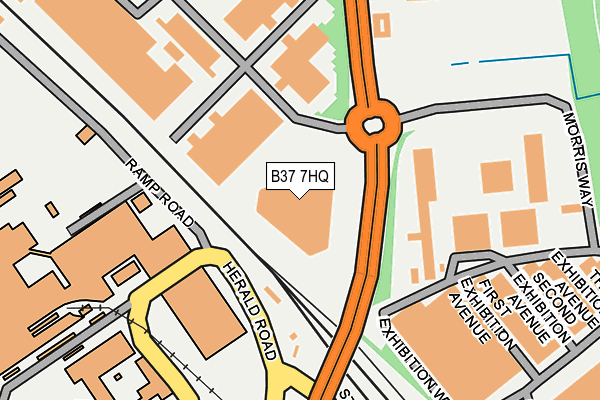
B37 7HQ lies on Bickenhill Lane in Birmingham. B37 7HQ is located in the Bickenhill electoral ward, within the metropolitan district of Solihull and the English Parliamentary constituency of Meriden. The Sub Integrated Care Board (ICB) Location is NHS Birmingham and Solihull ICB - 15E and the police force is West Midlands. This postcode has been in use since July 2017.


GetTheData
Source: OS OpenMap – Local (Ordnance Survey)
Source: OS VectorMap District (Ordnance Survey)
Licence: Open Government Licence (requires attribution)
| Easting | 418538 |
| Northing | 284061 |
| Latitude | 52.454207 |
| Longitude | -1.728625 |
GetTheData
Source: Open Postcode Geo
Licence: Open Government Licence
| Street | Bickenhill Lane |
| Town/City | Birmingham |
| Country | England |
| Postcode District | B37 |
➜ See where B37 is on a map ➜ Where is Birmingham? | |
GetTheData
Source: Land Registry Price Paid Data
Licence: Open Government Licence
| Ward | Bickenhill |
| Constituency | Meriden |
GetTheData
Source: ONS Postcode Database
Licence: Open Government Licence
| Railway Bridge (Bickenhill Lane) | National Exhibition Centre | 140m |
| Morris Way (Bickenhill Lane) | National Exhibition Centre | 167m |
| Morris Way (Bickenhill Lane) | National Exhibition Centre | 184m |
| Elmdon Trading Estate (Bickenhill Lane) | National Exhibition Centre | 373m |
| Elmdon Trading Estate (Bickenhill Lane) | National Exhibition Centre | 464m |
| Birmingham International Airport (Air-rail Link) | Birmingham Airport | 276m |
| Birmingham Intl Rail Station (Air-rail Link) | Birmingham Airport | 447m |
| Birmingham International Station | 0.4km |
| Marston Green Station | 2.3km |
| Hampton-in-Arden Station | 3.4km |
GetTheData
Source: NaPTAN
Licence: Open Government Licence
GetTheData
Source: ONS Postcode Database
Licence: Open Government Licence


➜ Get more ratings from the Food Standards Agency
GetTheData
Source: Food Standards Agency
Licence: FSA terms & conditions
| Last Collection | |||
|---|---|---|---|
| Location | Mon-Fri | Sat | Distance |
| Bham Intl Station | 17:00 | 12:00 | 433m |
| Bickenhill Road / Blackfirs Lane | 17:15 | 12:00 | 1,023m |
| Elmdon Trading Estate | 1,486m | ||
GetTheData
Source: Dracos
Licence: Creative Commons Attribution-ShareAlike
The below table lists the International Territorial Level (ITL) codes (formerly Nomenclature of Territorial Units for Statistics (NUTS) codes) and Local Administrative Units (LAU) codes for B37 7HQ:
| ITL 1 Code | Name |
|---|---|
| TLG | West Midlands (England) |
| ITL 2 Code | Name |
| TLG3 | West Midlands |
| ITL 3 Code | Name |
| TLG32 | Solihull |
| LAU 1 Code | Name |
| E08000029 | Solihull |
GetTheData
Source: ONS Postcode Directory
Licence: Open Government Licence
The below table lists the Census Output Area (OA), Lower Layer Super Output Area (LSOA), and Middle Layer Super Output Area (MSOA) for B37 7HQ:
| Code | Name | |
|---|---|---|
| OA | E00051123 | |
| LSOA | E01010109 | Solihull 009A |
| MSOA | E02002089 | Solihull 009 |
GetTheData
Source: ONS Postcode Directory
Licence: Open Government Licence
| B37 7EY | Bickenhill Lane | 875m |
| B37 7ES | 976m | |
| B37 7JE | Black Firs Lane | 988m |
| B37 7DX | Digby Drive | 1040m |
| B37 7EU | Bickenhill Road | 1046m |
| B37 7GY | Farndon Avenue | 1126m |
| B37 7FW | Moat House Lane | 1147m |
| B37 7EA | The Fordrift | 1169m |
| B37 7NW | The Stables Mews | 1170m |
| B37 7DT | Elmdon Lane | 1186m |
GetTheData
Source: Open Postcode Geo; Land Registry Price Paid Data
Licence: Open Government Licence