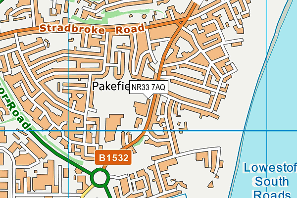
Pakefield High School is located in Pakefield, Lowestoft and falls under the local authority of Suffolk. This mixed-sex secondary school has 687 pupils, with a capacity of 900, aged from eleven up to sixteen, and the type of establishment is academy converter. The most recend Ofsted inspection was 28th September 2023 resulting in an good rating.
| Address | Pakefield High School London Road Pakefield Pakefield Lowestoft Suffolk NR33 7AQ |
| Website | http://www.pakefield.org.uk |
| Headteacher | Mr Daniel Bagshaw |
GetTheData
Source: Get Information About Schools
Licence: Open Government Licence
| Phase of Education | Secondary |
| Type of Establishment | Academy converter |
| Admissions Policy | Non-selective |
| Statutory Low Age | 11 |
| Statutory High Age | 16 |
| Boarders | No boarders |
| Official Sixth Form | Does not have a sixth form |
| Gender | Mixed |
| Religious Character | Does not apply |
| Diocese | Not applicable |
| Special Classes | No Special Classes |
GetTheData
Source: Get Information About Schools
Licence: Open Government Licence
| Census Date | 19th January 2023 | |
| School Capacity | 900 | |
| Number of Pupils | 687 | 76% capacity |
| Number of Boys | 346 | 50% |
| Number of Girls | 341 | 50% |
| Free School Meals (%) | 34.40% |
GetTheData
Source: Get Information About Schools
Licence: Open Government Licence
| Street Address | London Road Pakefield |
| Locality | Pakefield |
| Town | Lowestoft |
| County | Suffolk |
| Postcode | NR33 7AQ |
| ➜ More NR33 7AQ open data | |
GetTheData
Source: Get Information About Schools
Licence: Open Government Licence

GetTheData
Source: OS VectorMap District (Ordnance Survey)
Licence: Open Government Licence (requires attribution)
| Ofsted Last Inspection | 28th September 2023 |
| Ofsted Rating | Good |
| Ofsted Special Measures | Not applicable |
GetTheData
Source: Get Information About Schools
Licence: Open Government Licence
| Establishment Name | Pakefield High School |
| Establishment Number | 4605 |
| Unique Reference Number | 146909 |
| Local Authority | Suffolk |
| Local Authority Code | 935 |
| Previous Local Authority Code | 999 |
| Government Statistical Service Local Authority Code | E10000029 |
| Government Office Region | East of England |
| District | East Suffolk |
| District Code | E07000244 |
| Ward | Kirkley & Pakefield |
| Parliamentary Constituency | Waveney |
| Urban/Rural Description | (England/Wales) Urban city and town |
| Middle Super Output Area | East Suffolk 012 |
| Lower Super Output Area | East Suffolk 012E |
GetTheData
Source: Get Information About Schools
Licence: Open Government Licence
| Establishment Status | Open |
| Last Changed Date | 13th December 2023 |
| Reason Establishment Opened | Academy Converter |
| Open Date | 1st April 2019 |
GetTheData
Source: Get Information About Schools
Licence: Open Government Licence
| Teenage Mothers | Not applicable |
| Special Educational Needs (SEN) Provision in Primary Care Unit | Not applicable |
| Pupil Referral Unit (PRU) Provides for Educational and Behavioural Difficulties (EBD) | Not applicable |
GetTheData
Source: Get Information About Schools
Licence: Open Government Licence
| Section 41 Approved | Not applicable |
GetTheData
Source: Get Information About Schools
Licence: Open Government Licence
| Trust flag | Supported by a multi-academy trust |
| Trust | CLARION CORVUS TRUST |
| School Sponsor flag | Linked to a sponsor |
| School Sponsor | Clarion Academy Trust |
GetTheData
Source: Get Information About Schools
Licence: Open Government Licence
| Federation flag | Not applicable |
GetTheData
Source: Get Information About Schools
Licence: Open Government Licence
| UK Provider Reference Number | 10082969 |
| Further Education Type | Not applicable |
GetTheData
Source: Get Information About Schools
Licence: Open Government Licence
| Easting | 653215 |
| Northing | 289978 |
| Latitude | 52.44902 |
| Longitude | 1.72499 |
GetTheData
Source: Get Information About Schools
Licence: Open Government Licence
| School | Phase of Education | Distance |
|---|---|---|
| Pakefield Primary School London Road, Pakefield, Lowestoft, NR33 7AQ | Primary | 267m |
| Westwood Primary School Westwood Avenue, Westwood Primary School, Lowestoft, NR33 9RR | Primary | 1.3km |
| St Mary's Roman Catholic Primary School Kirkley Cliff Road, Lowestoft, NR33 0DG | Primary | 1.8km |
| Elm Tree Primary School Ranworth Avenue, Lowestoft, NR33 9HN | Primary | 1.8km |
| Grove Primary School Framfield Road, Carlton Colville, Lowestoft, NR33 8RQ | Primary | 1.9km |
| Phoenix St Peter Academy Enstone Road, Lowestoft, Suffolk, NR33 0NE | Primary | 2km |
| East Point Academy Kirkley Run, Lowestoft, NR33 0UQ | Secondary | 2.2km |
| Red Oak Primary School Southwell Road, Lowestoft, NR33 0RZ | Primary | 2.2km |
| Sunrise Academy Church Lane, Lowestoft, NR33 8AX | Not applicable | 2.3km |
| Carlton Colville Primary School Gisleham Road, Carlton Colville, Lowestoft, NR33 8DG | Primary | 2.3km |
GetTheData
Source: Get Information About Schools
Licence: Open Government Licence