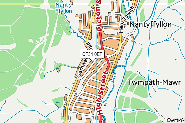
Nantyffyllon Primary School is located in Nantyffyllon, Bridgend and falls under the local authority of Bridgend. The type of establishment is welsh establishment.
| Address | Nantyffyllon Primary School Garnwen Terrace Nantyffyllon Maesteg Bridgend CF34 0ET |
GetTheData
Source: Get Information About Schools
Licence: Open Government Licence
| Phase of Education | Not applicable |
| Type of Establishment | Welsh establishment |
| Boarders | Not applicable |
| Official Sixth Form | Not applicable |
| Gender | Not applicable |
| Diocese | Not applicable |
| Special Classes | Not applicable |
GetTheData
Source: Get Information About Schools
Licence: Open Government Licence
| Street Address | Garnwen Terrace |
| Locality | Nantyffyllon |
| Address 3 | Maesteg |
| Town | Bridgend |
| Postcode | CF34 0ET |
| ➜ More CF34 0ET open data | |
GetTheData
Source: Get Information About Schools
Licence: Open Government Licence

GetTheData
Source: OS VectorMap District (Ordnance Survey)
Licence: Open Government Licence (requires attribution)
| Ofsted Special Measures | Not applicable |
GetTheData
Source: Get Information About Schools
Licence: Open Government Licence
| Establishment Name | Nantyffyllon Primary School |
| Establishment Number | 2172 |
| Unique Reference Number | 401043 |
| Local Authority | Bridgend |
| Local Authority Code | 672 |
| Previous Local Authority Code | 999 |
| Government Statistical Service Local Authority Code | W06000013 |
| Government Office Region | Wales (pseudo) |
| District | Bridgend |
| District Code | W06000013 |
| Ward | Caerau |
| Parliamentary Constituency | Ogmore |
| Urban/Rural Description | (England/Wales) Urban city and town |
| Middle Super Output Area | Bridgend 001 |
| Lower Super Output Area | Bridgend 001E |
GetTheData
Source: Get Information About Schools
Licence: Open Government Licence
| Establishment Status | Open |
| Last Changed Date | 13th June 2022 |
| Reason Establishment Opened | Not applicable |
| Reason Establishment Closed | Not applicable |
GetTheData
Source: Get Information About Schools
Licence: Open Government Licence
| Teenage Mothers | Not applicable |
| Child Care Facilities | Not applicable |
| Special Educational Needs (SEN) Provision in Primary Care Unit | Not applicable |
| Pupil Referral Unit (PRU) Provides for Educational and Behavioural Difficulties (EBD) | Not applicable |
| Pupil Referral Unit (PRU) Offers Tuition by Another Provider | Not applicable |
GetTheData
Source: Get Information About Schools
Licence: Open Government Licence
| Section 41 Approved | Not approved |
GetTheData
Source: Get Information About Schools
Licence: Open Government Licence
| Trust flag | Not applicable |
| School Sponsor flag | Not applicable |
GetTheData
Source: Get Information About Schools
Licence: Open Government Licence
| Federation flag | Not applicable |
GetTheData
Source: Get Information About Schools
Licence: Open Government Licence
| Further Education Type | Not applicable |
GetTheData
Source: Get Information About Schools
Licence: Open Government Licence
| Easting | 284992 |
| Northing | 192510 |
| Latitude | 51.61963 |
| Longitude | -3.66262 |
GetTheData
Source: Get Information About Schools
Licence: Open Government Licence
| School | Phase of Education | Distance |
|---|---|---|
| Plasnewydd Primary School Castle Street, Maesteg, Bridgend, CF34 9UN | Not applicable | 1.1km |
| Maesteg School Ffordd Dysgu, Maesteg, CF34 0LQ | Not applicable | 1.4km |
| St Mary's & St Patrick's Catholic Primary School Monica Street, Maesteg, Bridgend, CF34 9AY | Not applicable | 1.6km |
| YGG Cynwyd Sant Pen-Yr-Ysgol, Maesteg, Bridgend, CF34 9YE | Not applicable | 1.8km |
| Garth Primary School Mission Road, Garth, Maesteg, Bridgend, CF34 0ND | Not applicable | 2.7km |
| Cwmfelin Primary School Maesteg Road, Cwmfelin, Maesteg, Bridgend, CF34 9LD | Not applicable | 3.2km |
| Tarren School Eastern Avenue, Cymmer, SA13 3PB | Not applicable | 3.4km |
| Croeserw Primary School Bryn Siriol, Cymmer, Port Talbot, SA13 3PL | Not applicable | 3.4km |
| Cymer Afan Primary School Margam Street, Cymmer, Port Talbot, SA13 3EE | Not applicable | 3.6km |
| Llangynwyd Primary School Heol Cadrawd, Llangynwyd, Maesteg, Bridgend, CF34 9TE | Not applicable | 4.1km |
GetTheData
Source: Get Information About Schools
Licence: Open Government Licence