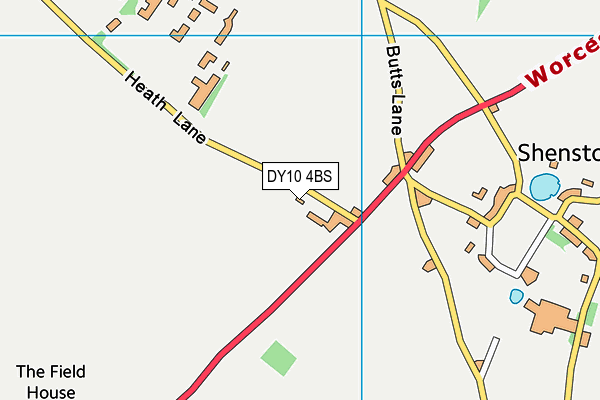
Madinatul Uloom Al Islamiya School is located in Summerfield, Worcestershire and falls under the local authority of Worcestershire. This boys only school has 223 pupils, with a capacity of 275, aged from eleven up to twenty-eight, and the type of establishment is other independent school. The most recend Ofsted inspection was 13th October 2022 resulting in an inadequate rating.
| Address | Madinatul Uloom Al Islamiya School Heath Lane Summerfield Kidderminster Worcestershire Worcestershire DY10 4BS |
| Headteacher | Mr A Memi |
GetTheData
Source: Get Information About Schools
Licence: Open Government Licence
| Phase of Education | Not applicable |
| Type of Establishment | Other independent school |
| Admissions Policy | Selective |
| Statutory Low Age | 11 |
| Statutory High Age | 28 |
| Boarders | Boarding school |
| Boarding Establishment | Has boarders |
| Official Sixth Form | Has a sixth form |
| Gender | Boys |
| Religious Character | None |
| Diocese | Not applicable |
| Special Classes | No Special Classes |
GetTheData
Source: Get Information About Schools
Licence: Open Government Licence
| Census Date | 20th January 2022 | |
| School Capacity | 275 | |
| Number of Pupils | 223 | 81% capacity |
| Number of Boys | 223 | |
| Free School Meals (%) | 0.0% |
GetTheData
Source: Get Information About Schools
Licence: Open Government Licence
| Street Address | Heath Lane |
| Locality | Summerfield |
| Address 3 | Kidderminster |
| Town | Worcestershire |
| County | Worcestershire |
| Postcode | DY10 4BS |
| ➜ More DY10 4BS open data | |
GetTheData
Source: Get Information About Schools
Licence: Open Government Licence

GetTheData
Source: OS VectorMap District (Ordnance Survey)
Licence: Open Government Licence (requires attribution)
| Ofsted Last Inspection | 13th October 2022 |
| Ofsted Rating | Inadequate |
| Ofsted Special Measures | Not applicable |
GetTheData
Source: Get Information About Schools
Licence: Open Government Licence
| Establishment Name | Madinatul Uloom Al Islamiya School |
| Establishment Number | 6031 |
| Previous Establishment Number | 6115 |
| Unique Reference Number | 117044 |
| Local Authority | Worcestershire |
| Local Authority Code | 885 |
| Previous Local Authority | Pre LGR (1998) Hereford & Worcester |
| Previous Local Authority Code | 918 |
| Government Statistical Service Local Authority Code | E10000034 |
| Government Office Region | West Midlands |
| District | Wyre Forest |
| District Code | E07000239 |
| Ward | Wyre Forest Rural |
| Parliamentary Constituency | Wyre Forest |
| Urban/Rural Description | (England/Wales) Rural village |
| Middle Super Output Area | Wyre Forest 001 |
| Lower Super Output Area | Wyre Forest 001A |
GetTheData
Source: Get Information About Schools
Licence: Open Government Licence
| Establishment Status | Open |
| Last Changed Date | 6th December 2023 |
| Reason Establishment Opened | Not applicable |
| Open Date | 10th August 1988 |
| Reason Establishment Closed | Not applicable |
GetTheData
Source: Get Information About Schools
Licence: Open Government Licence
| Teenage Mothers | Not applicable |
| Child Care Facilities | Not applicable |
| Special Educational Needs (SEN) Provision in Primary Care Unit | Not applicable |
| Pupil Referral Unit (PRU) Provides for Educational and Behavioural Difficulties (EBD) | Not applicable |
| Pupil Referral Unit (PRU) Offers Tuition by Another Provider | Not applicable |
GetTheData
Source: Get Information About Schools
Licence: Open Government Licence
| Section 41 Approved | Not approved |
GetTheData
Source: Get Information About Schools
Licence: Open Government Licence
| Trust flag | Not applicable |
| School Sponsor flag | Not applicable |
GetTheData
Source: Get Information About Schools
Licence: Open Government Licence
| Federation flag | Not applicable |
GetTheData
Source: Get Information About Schools
Licence: Open Government Licence
| UK Provider Reference Number | 10016427 |
| Further Education Type | Not applicable |
GetTheData
Source: Get Information About Schools
Licence: Open Government Licence
| Easting | 385611 |
| Northing | 273858 |
| Latitude | 52.36259 |
| Longitude | -2.21273 |
GetTheData
Source: Get Information About Schools
Licence: Open Government Licence
| School | Phase of Education | Distance |
|---|---|---|
| Heronswood Primary School Heronswood Road, Kidderminster, DY10 4EX | Primary | 1.6km |
| Comberton Primary School Borrington Road, Comberton Primary School, KIDDERMINSTER, DY10 3ED | Primary | 2.3km |
| King Charles I School Hill Grove House, Comberton Road, Kidderminster, DY10 1XA | Secondary | 2.7km |
| Offmore Primary School Wordsworth Crescent, Offmore Primary School, KIDDERMINSTER, DY10 3HA | Primary | 3.1km |
| Hartlebury CofE Primary School The Village, Hartlebury, Kidderminster, DY11 7TD | Primary | 3.2km |
| Foley Park Primary Academy Northumberland Avenue, Kidderminster, DY11 7AW | Primary | 3.5km |
| St Ambrose Catholic Primary Leswell Street, Saint Ambrose School, Kidderminster, DY10 1RP | Primary | 3.5km |
| Cambian New Elizabethan School Quarry Bank, Hartlebury, DY11 7TE | Not applicable | 3.5km |
| Wilden All Saints CofE Primary School Wilden Lane, Stourport-on-Severn, DY13 9LP | Primary | 3.6km |
| Holy Trinity School Birmingham Road, Kidderminster, DY10 2BY | All-through | 3.6km |
GetTheData
Source: Get Information About Schools
Licence: Open Government Licence