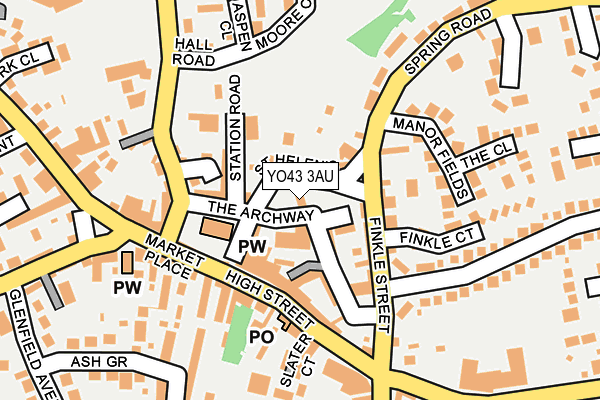
YO43 3AU lies on The Green in Market Weighton, York. YO43 3AU is located in the Wolds Weighton electoral ward, within the unitary authority of East Riding of Yorkshire and the English Parliamentary constituency of East Yorkshire. The Sub Integrated Care Board (ICB) Location is NHS Humber and North Yorkshire ICB - 02Y and the police force is Humberside. This postcode has been in use since June 1998.


GetTheData
Source: OS OpenMap – Local (Ordnance Survey)
Source: OS VectorMap District (Ordnance Survey)
Licence: Open Government Licence (requires attribution)
| Easting | 487843 |
| Northing | 441825 |
| Latitude | 53.865216 |
| Longitude | -0.665697 |
GetTheData
Source: Open Postcode Geo
Licence: Open Government Licence
| Street | The Green |
| Locality | Market Weighton |
| Town/City | York |
| Country | England |
| Postcode District | YO43 |
➜ See where YO43 is on a map ➜ Where is Market Weighton? | |
GetTheData
Source: Land Registry Price Paid Data
Licence: Open Government Licence
Elevation or altitude of YO43 3AU as distance above sea level:
| Metres | Feet | |
|---|---|---|
| Elevation | 30m | 98ft |
Elevation is measured from the approximate centre of the postcode, to the nearest point on an OS contour line from OS Terrain 50, which has contour spacing of ten vertical metres.
➜ How high above sea level am I? Find the elevation of your current position using your device's GPS.
GetTheData
Source: Open Postcode Elevation
Licence: Open Government Licence
| Ward | Wolds Weighton |
| Constituency | East Yorkshire |
GetTheData
Source: ONS Postcode Database
Licence: Open Government Licence
| Market Weighton Market Pl (Market Place) | Market Weighton | 167m |
| Market Weighton High St (High Street) | Market Weighton | 170m |
| Market Weighton York Rd (York Road) | Market Weighton | 223m |
| Market Weighton Southgate (Southgate) | Market Weighton | 366m |
| Market Weighton Southgate (Southgate) | Market Weighton | 385m |
GetTheData
Source: NaPTAN
Licence: Open Government Licence
| Percentage of properties with Next Generation Access | 0.0% |
| Percentage of properties with Superfast Broadband | 0.0% |
| Percentage of properties with Ultrafast Broadband | 0.0% |
| Percentage of properties with Full Fibre Broadband | 0.0% |
Superfast Broadband is between 30Mbps and 300Mbps
Ultrafast Broadband is > 300Mbps
| Percentage of properties unable to receive 2Mbps | 0.0% |
| Percentage of properties unable to receive 5Mbps | 0.0% |
| Percentage of properties unable to receive 10Mbps | 0.0% |
| Percentage of properties unable to receive 30Mbps | 100.0% |
GetTheData
Source: Ofcom
Licence: Ofcom Terms of Use (requires attribution)
GetTheData
Source: ONS Postcode Database
Licence: Open Government Licence


➜ Get more ratings from the Food Standards Agency
GetTheData
Source: Food Standards Agency
Licence: FSA terms & conditions
| Last Collection | |||
|---|---|---|---|
| Location | Mon-Fri | Sat | Distance |
| Market Weighton Post Office | 17:45 | 12:30 | 111m |
| Springfield Road Market Weighton | 17:45 | 11:30 | 382m |
| 20 Hill Rise Drive M/Weighton | 17:45 | 11:30 | 392m |
GetTheData
Source: Dracos
Licence: Creative Commons Attribution-ShareAlike
| Risk of YO43 3AU flooding from rivers and sea | Very Low |
| ➜ YO43 3AU flood map | |
GetTheData
Source: Open Flood Risk by Postcode
Licence: Open Government Licence
The below table lists the International Territorial Level (ITL) codes (formerly Nomenclature of Territorial Units for Statistics (NUTS) codes) and Local Administrative Units (LAU) codes for YO43 3AU:
| ITL 1 Code | Name |
|---|---|
| TLE | Yorkshire and The Humber |
| ITL 2 Code | Name |
| TLE1 | East Yorkshire and Northern Lincolnshire |
| ITL 3 Code | Name |
| TLE12 | East Riding of Yorkshire |
| LAU 1 Code | Name |
| E06000011 | East Riding of Yorkshire |
GetTheData
Source: ONS Postcode Directory
Licence: Open Government Licence
The below table lists the Census Output Area (OA), Lower Layer Super Output Area (LSOA), and Middle Layer Super Output Area (MSOA) for YO43 3AU:
| Code | Name | |
|---|---|---|
| OA | E00066225 | |
| LSOA | E01013120 | East Riding of Yorkshire 015A |
| MSOA | E02002698 | East Riding of Yorkshire 015 |
GetTheData
Source: ONS Postcode Directory
Licence: Open Government Licence
| YO43 3NT | All Saints Court | 22m |
| YO43 3AT | St Helens Square | 29m |
| YO43 3NF | The Maltings | 54m |
| YO43 3AS | Church Side | 58m |
| YO43 3NE | The Archway | 71m |
| YO43 3BD | Church Close | 75m |
| YO43 3QS | Finkle Mews | 77m |
| YO43 3QT | The Archway | 79m |
| YO43 3JL | Finkle Street | 87m |
| YO43 3AX | Station Road | 91m |
GetTheData
Source: Open Postcode Geo; Land Registry Price Paid Data
Licence: Open Government Licence