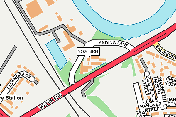
YO26 4RH is located in the Holgate electoral ward, within the unitary authority of York and the English Parliamentary constituency of York Central. The Sub Integrated Care Board (ICB) Location is NHS Humber and North Yorkshire ICB - 03Q and the police force is North Yorkshire. This postcode has been in use since June 1998.


GetTheData
Source: OS OpenMap – Local (Ordnance Survey)
Source: OS VectorMap District (Ordnance Survey)
Licence: Open Government Licence (requires attribution)
| Easting | 458322 |
| Northing | 452458 |
| Latitude | 53.964939 |
| Longitude | -1.112520 |
GetTheData
Source: Open Postcode Geo
Licence: Open Government Licence
| Country | England |
| Postcode District | YO26 |
➜ See where YO26 is on a map ➜ Where is York? | |
GetTheData
Source: Land Registry Price Paid Data
Licence: Open Government Licence
Elevation or altitude of YO26 4RH as distance above sea level:
| Metres | Feet | |
|---|---|---|
| Elevation | 10m | 33ft |
Elevation is measured from the approximate centre of the postcode, to the nearest point on an OS contour line from OS Terrain 50, which has contour spacing of ten vertical metres.
➜ How high above sea level am I? Find the elevation of your current position using your device's GPS.
GetTheData
Source: Open Postcode Elevation
Licence: Open Government Licence
| Ward | Holgate |
| Constituency | York Central |
GetTheData
Source: ONS Postcode Database
Licence: Open Government Licence
| Landing Lane (Water End) | Clifton | 155m |
| Salisbury Road | Clifton | 323m |
| Salisbury Road | Clifton | 323m |
| Seldon Road (Poppleton Road) | Holgate | 373m |
| Livingstone Street | Clifton | 376m |
| York Station | 1.5km |
| Poppleton Station | 2.7km |
GetTheData
Source: NaPTAN
Licence: Open Government Licence
GetTheData
Source: ONS Postcode Database
Licence: Open Government Licence


➜ Get more ratings from the Food Standards Agency
GetTheData
Source: Food Standards Agency
Licence: FSA terms & conditions
| Last Collection | |||
|---|---|---|---|
| Location | Mon-Fri | Sat | Distance |
| Manor Drive | 17:45 | 12:30 | 368m |
| Bright Street Post Office | 18:00 | 12:45 | 390m |
| 97 Poppleton Road York | 17:45 | 12:15 | 465m |
GetTheData
Source: Dracos
Licence: Creative Commons Attribution-ShareAlike
The below table lists the International Territorial Level (ITL) codes (formerly Nomenclature of Territorial Units for Statistics (NUTS) codes) and Local Administrative Units (LAU) codes for YO26 4RH:
| ITL 1 Code | Name |
|---|---|
| TLE | Yorkshire and The Humber |
| ITL 2 Code | Name |
| TLE2 | North Yorkshire |
| ITL 3 Code | Name |
| TLE21 | York |
| LAU 1 Code | Name |
| E06000014 | York |
GetTheData
Source: ONS Postcode Directory
Licence: Open Government Licence
The below table lists the Census Output Area (OA), Lower Layer Super Output Area (LSOA), and Middle Layer Super Output Area (MSOA) for YO26 4RH:
| Code | Name | |
|---|---|---|
| OA | E00067634 | |
| LSOA | E01013392 | York 012F |
| MSOA | E02002783 | York 012 |
GetTheData
Source: ONS Postcode Directory
Licence: Open Government Licence
| YO26 4XY | Bismarck Street | 212m |
| YO26 4TW | Poplar Court | 234m |
| YO26 5RX | Lavender Grove | 251m |
| YO26 4XX | Garnet Terrace | 258m |
| YO26 4XZ | Upper Hanover Street | 281m |
| YO26 4YN | Salisbury Road | 281m |
| YO26 4YA | Walworth Street North | 285m |
| YO26 4SG | Poplar Street | 288m |
| YO26 4YL | Chudleigh Road | 295m |
| YO26 4UY | Stamford Street West | 297m |
GetTheData
Source: Open Postcode Geo; Land Registry Price Paid Data
Licence: Open Government Licence