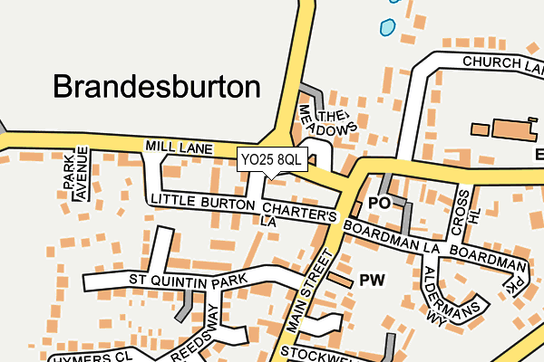
YO25 8QL is located in the East Wolds and Coastal electoral ward, within the unitary authority of East Riding of Yorkshire and the English Parliamentary constituency of East Yorkshire. The Sub Integrated Care Board (ICB) Location is NHS Humber and North Yorkshire ICB - 02Y and the police force is Humberside. This postcode has been in use since January 1980.


GetTheData
Source: OS OpenMap – Local (Ordnance Survey)
Source: OS VectorMap District (Ordnance Survey)
Licence: Open Government Licence (requires attribution)
| Easting | 511612 |
| Northing | 447574 |
| Latitude | 53.912324 |
| Longitude | -0.302327 |
GetTheData
Source: Open Postcode Geo
Licence: Open Government Licence
| Country | England |
| Postcode District | YO25 |
➜ See where YO25 is on a map ➜ Where is Brandesburton? | |
GetTheData
Source: Land Registry Price Paid Data
Licence: Open Government Licence
Elevation or altitude of YO25 8QL as distance above sea level:
| Metres | Feet | |
|---|---|---|
| Elevation | 10m | 33ft |
Elevation is measured from the approximate centre of the postcode, to the nearest point on an OS contour line from OS Terrain 50, which has contour spacing of ten vertical metres.
➜ How high above sea level am I? Find the elevation of your current position using your device's GPS.
GetTheData
Source: Open Postcode Elevation
Licence: Open Government Licence
| Ward | East Wolds And Coastal |
| Constituency | East Yorkshire |
GetTheData
Source: ONS Postcode Database
Licence: Open Government Licence
| Brandesburton Main Street (Main Street) | Brandesburton | 139m |
| Brandesburton Main Street (Main Street) | Brandesburton | 145m |
| Brandesburton Main Street (Main Street) | Brandesburton | 173m |
| Brandesburton Main Street (Main Street) | Brandesburton | 175m |
| Brandesburton Main Street (Main Street) | Brandesburton | 412m |
GetTheData
Source: NaPTAN
Licence: Open Government Licence
| Percentage of properties with Next Generation Access | 100.0% |
| Percentage of properties with Superfast Broadband | 100.0% |
| Percentage of properties with Ultrafast Broadband | 0.0% |
| Percentage of properties with Full Fibre Broadband | 0.0% |
Superfast Broadband is between 30Mbps and 300Mbps
Ultrafast Broadband is > 300Mbps
| Percentage of properties unable to receive 2Mbps | 0.0% |
| Percentage of properties unable to receive 5Mbps | 0.0% |
| Percentage of properties unable to receive 10Mbps | 0.0% |
| Percentage of properties unable to receive 30Mbps | 0.0% |
GetTheData
Source: Ofcom
Licence: Ofcom Terms of Use (requires attribution)
GetTheData
Source: ONS Postcode Database
Licence: Open Government Licence


➜ Get more ratings from the Food Standards Agency
GetTheData
Source: Food Standards Agency
Licence: FSA terms & conditions
| Last Collection | |||
|---|---|---|---|
| Location | Mon-Fri | Sat | Distance |
| Catfoss Camp | 16:00 | 11:00 | 2,901m |
| Sigglesthorne | 17:00 | 11:00 | 4,337m |
| Wassand Hall | 16:45 | 11:15 | 4,354m |
GetTheData
Source: Dracos
Licence: Creative Commons Attribution-ShareAlike
The below table lists the International Territorial Level (ITL) codes (formerly Nomenclature of Territorial Units for Statistics (NUTS) codes) and Local Administrative Units (LAU) codes for YO25 8QL:
| ITL 1 Code | Name |
|---|---|
| TLE | Yorkshire and The Humber |
| ITL 2 Code | Name |
| TLE1 | East Yorkshire and Northern Lincolnshire |
| ITL 3 Code | Name |
| TLE12 | East Riding of Yorkshire |
| LAU 1 Code | Name |
| E06000011 | East Riding of Yorkshire |
GetTheData
Source: ONS Postcode Directory
Licence: Open Government Licence
The below table lists the Census Output Area (OA), Lower Layer Super Output Area (LSOA), and Middle Layer Super Output Area (MSOA) for YO25 8QL:
| Code | Name | |
|---|---|---|
| OA | E00065504 | |
| LSOA | E01012988 | East Riding of Yorkshire 010C |
| MSOA | E02002693 | East Riding of Yorkshire 010 |
GetTheData
Source: ONS Postcode Directory
Licence: Open Government Licence
| YO25 8QY | Frodingham Road | 20m |
| YO25 8PE | Orchard Mews | 39m |
| YO25 8QJ | Charters Lane | 60m |
| YO25 8QG | The Meadows | 80m |
| YO25 8RH | Main Street | 95m |
| YO25 8QW | Mill Lane | 98m |
| YO25 8QN | Little Burton | 113m |
| YO25 8SE | St Quintin Park | 121m |
| YO25 8RD | Boardman Lane | 162m |
| YO25 8RZ | Blenheim Walk | 165m |
GetTheData
Source: Open Postcode Geo; Land Registry Price Paid Data
Licence: Open Government Licence