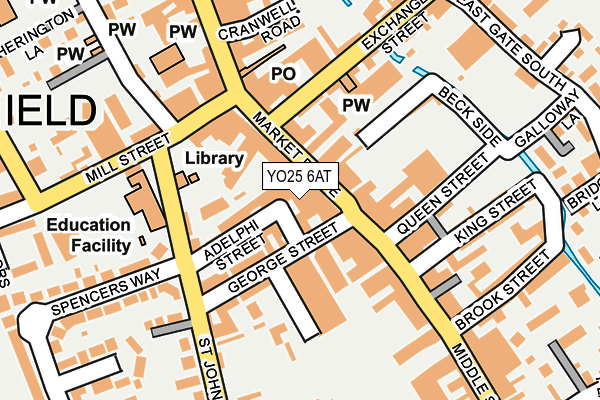
YO25 6AT is located in the Driffield and Rural electoral ward, within the unitary authority of East Riding of Yorkshire and the English Parliamentary constituency of East Yorkshire. The Sub Integrated Care Board (ICB) Location is NHS Humber and North Yorkshire ICB - 02Y and the police force is Humberside. This postcode has been in use since January 2005.


GetTheData
Source: OS OpenMap – Local (Ordnance Survey)
Source: OS VectorMap District (Ordnance Survey)
Licence: Open Government Licence (requires attribution)
| Easting | 502398 |
| Northing | 457648 |
| Latitude | 54.004713 |
| Longitude | -0.439153 |
GetTheData
Source: Open Postcode Geo
Licence: Open Government Licence
| Country | England |
| Postcode District | YO25 |
➜ See where YO25 is on a map ➜ Where is Driffield? | |
GetTheData
Source: Land Registry Price Paid Data
Licence: Open Government Licence
Elevation or altitude of YO25 6AT as distance above sea level:
| Metres | Feet | |
|---|---|---|
| Elevation | 20m | 66ft |
Elevation is measured from the approximate centre of the postcode, to the nearest point on an OS contour line from OS Terrain 50, which has contour spacing of ten vertical metres.
➜ How high above sea level am I? Find the elevation of your current position using your device's GPS.
GetTheData
Source: Open Postcode Elevation
Licence: Open Government Licence
| Ward | Driffield And Rural |
| Constituency | East Yorkshire |
GetTheData
Source: ONS Postcode Database
Licence: Open Government Licence
| Driffield Market Place (Market Place) | Driffield | 27m |
| Driffield George Street (George Street) | Driffield | 39m |
| Driffield George Street (George Street) | Driffield | 47m |
| Driffield Middle St South (Middle Street South) | Driffield | 79m |
| Driffield St John's Road (St John's Road) | Driffield | 124m |
| Driffield Station | 0.5km |
| Nafferton Station | 3.6km |
GetTheData
Source: NaPTAN
Licence: Open Government Licence
GetTheData
Source: ONS Postcode Database
Licence: Open Government Licence


➜ Get more ratings from the Food Standards Agency
GetTheData
Source: Food Standards Agency
Licence: FSA terms & conditions
| Last Collection | |||
|---|---|---|---|
| Location | Mon-Fri | Sat | Distance |
| Market Place Driffield | 17:30 | 12:15 | 25m |
| 39 Exchange Street Driffield | 17:30 | 12:30 | 236m |
| 1 Mill Street Driffield | 17:30 | 12:45 | 241m |
GetTheData
Source: Dracos
Licence: Creative Commons Attribution-ShareAlike
The below table lists the International Territorial Level (ITL) codes (formerly Nomenclature of Territorial Units for Statistics (NUTS) codes) and Local Administrative Units (LAU) codes for YO25 6AT:
| ITL 1 Code | Name |
|---|---|
| TLE | Yorkshire and The Humber |
| ITL 2 Code | Name |
| TLE1 | East Yorkshire and Northern Lincolnshire |
| ITL 3 Code | Name |
| TLE12 | East Riding of Yorkshire |
| LAU 1 Code | Name |
| E06000011 | East Riding of Yorkshire |
GetTheData
Source: ONS Postcode Directory
Licence: Open Government Licence
The below table lists the Census Output Area (OA), Lower Layer Super Output Area (LSOA), and Middle Layer Super Output Area (MSOA) for YO25 6AT:
| Code | Name | |
|---|---|---|
| OA | E00065457 | |
| LSOA | E01012982 | East Riding of Yorkshire 045D |
| MSOA | E02006892 | East Riding of Yorkshire 045 |
GetTheData
Source: ONS Postcode Directory
Licence: Open Government Licence
| YO25 6AW | Market Place | 47m |
| YO25 6AP | Market Place | 52m |
| YO25 6RF | Adelphi Street | 72m |
| YO25 6BW | Market Walk | 74m |
| YO25 6PH | Middle Street South | 76m |
| YO25 6RA | George Street | 85m |
| YO25 6QQ | Providence Place | 89m |
| YO25 6RQ | Cross Hill | 109m |
| YO25 6RG | St Johns Road | 117m |
| YO25 6AN | Market Place | 136m |
GetTheData
Source: Open Postcode Geo; Land Registry Price Paid Data
Licence: Open Government Licence