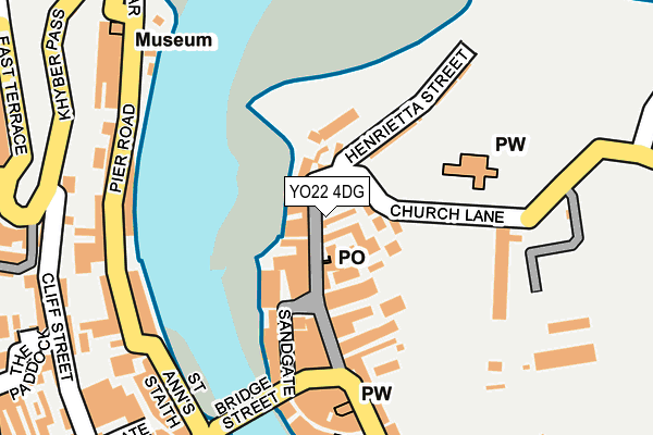
YO22 4DG lies on Woodwarks Yard in Whitby. YO22 4DG is located in the Whitby Streonshalh electoral ward, within the unitary authority of North Yorkshire and the English Parliamentary constituency of Scarborough and Whitby. The Sub Integrated Care Board (ICB) Location is NHS Humber and North Yorkshire ICB - 42D and the police force is North Yorkshire. This postcode has been in use since January 1980.


GetTheData
Source: OS OpenMap – Local (Ordnance Survey)
Source: OS VectorMap District (Ordnance Survey)
Licence: Open Government Licence (requires attribution)
| Easting | 490019 |
| Northing | 511246 |
| Latitude | 54.488591 |
| Longitude | -0.611905 |
GetTheData
Source: Open Postcode Geo
Licence: Open Government Licence
| Street | Woodwarks Yard |
| Town/City | Whitby |
| Country | England |
| Postcode District | YO22 |
➜ See where YO22 is on a map ➜ Where is Whitby? | |
GetTheData
Source: Land Registry Price Paid Data
Licence: Open Government Licence
Elevation or altitude of YO22 4DG as distance above sea level:
| Metres | Feet | |
|---|---|---|
| Elevation | 10m | 33ft |
Elevation is measured from the approximate centre of the postcode, to the nearest point on an OS contour line from OS Terrain 50, which has contour spacing of ten vertical metres.
➜ How high above sea level am I? Find the elevation of your current position using your device's GPS.
GetTheData
Source: Open Postcode Elevation
Licence: Open Government Licence
| Ward | Whitby Streonshalh |
| Constituency | Scarborough And Whitby |
GetTheData
Source: ONS Postcode Database
Licence: Open Government Licence
| Well Court (Grape Lane) | Whitby | 214m |
| Well Court (Grape Lane) | Whitby | 215m |
| Abbey (Abbey Lane) | Whitby | 223m |
| Havelock Place (Belle Vue Terrace) | West Cliff | 373m |
| Eskside Cottages (Church Street) | Whitby | 414m |
| Whitby Station | 0.5km |
| Ruswarp Station | 2.3km |
| Sleights Station | 4.5km |
GetTheData
Source: NaPTAN
Licence: Open Government Licence
GetTheData
Source: ONS Postcode Database
Licence: Open Government Licence


➜ Get more ratings from the Food Standards Agency
GetTheData
Source: Food Standards Agency
Licence: FSA terms & conditions
| Last Collection | |||
|---|---|---|---|
| Location | Mon-Fri | Sat | Distance |
| Church Street Post Office | 17:15 | 11:45 | 34m |
| The Pier | 17:30 | 12:45 | 191m |
| Midlands Bank Baxtergate | 17:30 | 12:00 | 260m |
GetTheData
Source: Dracos
Licence: Creative Commons Attribution-ShareAlike
The below table lists the International Territorial Level (ITL) codes (formerly Nomenclature of Territorial Units for Statistics (NUTS) codes) and Local Administrative Units (LAU) codes for YO22 4DG:
| ITL 1 Code | Name |
|---|---|
| TLE | Yorkshire and The Humber |
| ITL 2 Code | Name |
| TLE2 | North Yorkshire |
| ITL 3 Code | Name |
| TLE22 | North Yorkshire CC |
| LAU 1 Code | Name |
| E07000168 | Scarborough |
GetTheData
Source: ONS Postcode Directory
Licence: Open Government Licence
The below table lists the Census Output Area (OA), Lower Layer Super Output Area (LSOA), and Middle Layer Super Output Area (MSOA) for YO22 4DG:
| Code | Name | |
|---|---|---|
| OA | E00141965 | |
| LSOA | E01027865 | Scarborough 003C |
| MSOA | E02005797 | Scarborough 003 |
GetTheData
Source: ONS Postcode Directory
Licence: Open Government Licence
| YO22 4DQ | Bensons Yard | 7m |
| YO22 4DE | Church Street | 10m |
| YO22 4DF | Kiln Yard | 27m |
| YO22 4DH | New Way Ghaut | 32m |
| YO22 4BQ | Lees Yard | 36m |
| YO22 4DJ | Arguments Yard | 46m |
| YO22 4DS | Blackburns Yard | 50m |
| YO22 4BJ | Borough Place | 60m |
| YO22 4DR | East Abbey Terrace | 62m |
| YO22 4DL | Tate Hill | 64m |
GetTheData
Source: Open Postcode Geo; Land Registry Price Paid Data
Licence: Open Government Licence