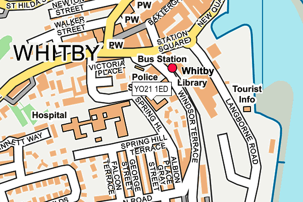
YO21 1ED is located in the Whitby Streonshalh electoral ward, within the unitary authority of North Yorkshire and the English Parliamentary constituency of Scarborough and Whitby. The Sub Integrated Care Board (ICB) Location is NHS Humber and North Yorkshire ICB - 42D and the police force is North Yorkshire. This postcode has been in use since January 1995.


GetTheData
Source: OS OpenMap – Local (Ordnance Survey)
Source: OS VectorMap District (Ordnance Survey)
Licence: Open Government Licence (requires attribution)
| Easting | 489781 |
| Northing | 510753 |
| Latitude | 54.484189 |
| Longitude | -0.615710 |
GetTheData
Source: Open Postcode Geo
Licence: Open Government Licence
| Country | England |
| Postcode District | YO21 |
➜ See where YO21 is on a map ➜ Where is Whitby? | |
GetTheData
Source: Land Registry Price Paid Data
Licence: Open Government Licence
Elevation or altitude of YO21 1ED as distance above sea level:
| Metres | Feet | |
|---|---|---|
| Elevation | 10m | 33ft |
Elevation is measured from the approximate centre of the postcode, to the nearest point on an OS contour line from OS Terrain 50, which has contour spacing of ten vertical metres.
➜ How high above sea level am I? Find the elevation of your current position using your device's GPS.
GetTheData
Source: Open Postcode Elevation
Licence: Open Government Licence
| Ward | Whitby Streonshalh |
| Constituency | Scarborough And Whitby |
GetTheData
Source: ONS Postcode Database
Licence: Open Government Licence
| Hospital (Spring Hill) | Whitby | 20m |
| Bus Stn Stand 3 (Windsor Terrace) | Whitby | 89m |
| Bus Stn Stand 4 (Bagdale) | Whitby | 100m |
| Boyes (Victoria Square) | Whitby | 110m |
| Co-op (Langbourne Road) | Whitby | 148m |
| Whitby Station | 0.1km |
| Ruswarp Station | 1.7km |
| Sleights Station | 4km |
GetTheData
Source: NaPTAN
Licence: Open Government Licence
GetTheData
Source: ONS Postcode Database
Licence: Open Government Licence


➜ Get more ratings from the Food Standards Agency
GetTheData
Source: Food Standards Agency
Licence: FSA terms & conditions
| Last Collection | |||
|---|---|---|---|
| Location | Mon-Fri | Sat | Distance |
| Fishburn Park Post Office | 16:45 | 12:30 | 179m |
| 34 Flowergate Whitby | 17:30 | 11:45 | 263m |
| Midlands Bank Baxtergate | 17:30 | 12:00 | 288m |
GetTheData
Source: Dracos
Licence: Creative Commons Attribution-ShareAlike
The below table lists the International Territorial Level (ITL) codes (formerly Nomenclature of Territorial Units for Statistics (NUTS) codes) and Local Administrative Units (LAU) codes for YO21 1ED:
| ITL 1 Code | Name |
|---|---|
| TLE | Yorkshire and The Humber |
| ITL 2 Code | Name |
| TLE2 | North Yorkshire |
| ITL 3 Code | Name |
| TLE22 | North Yorkshire CC |
| LAU 1 Code | Name |
| E07000168 | Scarborough |
GetTheData
Source: ONS Postcode Directory
Licence: Open Government Licence
The below table lists the Census Output Area (OA), Lower Layer Super Output Area (LSOA), and Middle Layer Super Output Area (MSOA) for YO21 1ED:
| Code | Name | |
|---|---|---|
| OA | E00141997 | |
| LSOA | E01027870 | Scarborough 001D |
| MSOA | E02005795 | Scarborough 001 |
GetTheData
Source: ONS Postcode Directory
Licence: Open Government Licence
| YO21 1EX | Windsor Crescent | 54m |
| YO21 1ET | Windsor Terrace | 93m |
| YO21 1EG | Springhill Terrace | 97m |
| YO21 1EZ | Victoria Place | 101m |
| YO21 1DZ | Princess Place | 104m |
| YO21 1ER | Albion Terrace | 113m |
| YO21 1DX | Station Square | 122m |
| YO21 1EA | Victoria Square | 124m |
| YO21 1ES | Albion Place | 129m |
| YO21 1BN | Baxtergate | 131m |
GetTheData
Source: Open Postcode Geo; Land Registry Price Paid Data
Licence: Open Government Licence