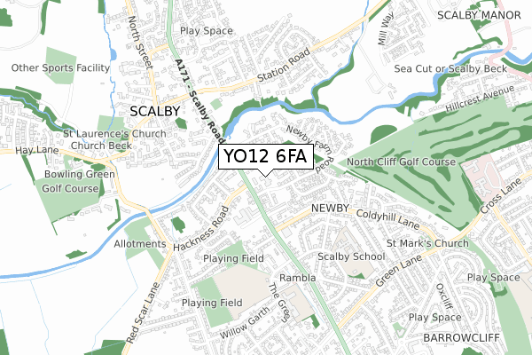
YO12 6FA is located in the Scalby & the Coast electoral ward, within the unitary authority of North Yorkshire and the English Parliamentary constituency of Scarborough and Whitby. The Sub Integrated Care Board (ICB) Location is NHS Humber and North Yorkshire ICB - 42D and the police force is North Yorkshire. This postcode has been in use since September 2019.


GetTheData
Source: OS Open Zoomstack (Ordnance Survey)
Licence: Open Government Licence (requires attribution)
Attribution: Contains OS data © Crown copyright and database right 2024
Source: Open Postcode Geo
Licence: Open Government Licence (requires attribution)
Attribution: Contains OS data © Crown copyright and database right 2024; Contains Royal Mail data © Royal Mail copyright and database right 2024; Source: Office for National Statistics licensed under the Open Government Licence v.3.0
| Easting | 501475 |
| Northing | 489978 |
| Latitude | 54.295369 |
| Longitude | -0.442381 |
GetTheData
Source: Open Postcode Geo
Licence: Open Government Licence
| Country | England |
| Postcode District | YO12 |
➜ See where YO12 is on a map ➜ Where is Scarborough? | |
GetTheData
Source: Land Registry Price Paid Data
Licence: Open Government Licence
| Ward | Scalby & The Coast |
| Constituency | Scarborough And Whitby |
GetTheData
Source: ONS Postcode Database
Licence: Open Government Licence
| Keld Close (Scalby Road) | Newby | 97m |
| Hackness Drive (Hackness Road) | Newby | 114m |
| The Rosette (Hackness Road) | Newby | 129m |
| The Rosette (Hackness Road) | Newby | 134m |
| Hackness Drive (Hackness Road) | Newby | 139m |
| Scarborough Station | 2.9km |
GetTheData
Source: NaPTAN
Licence: Open Government Licence
GetTheData
Source: ONS Postcode Database
Licence: Open Government Licence


➜ Get more ratings from the Food Standards Agency
GetTheData
Source: Food Standards Agency
Licence: FSA terms & conditions
| Last Collection | |||
|---|---|---|---|
| Location | Mon-Fri | Sat | Distance |
| Scalby Post Office | 17:00 | 12:25 | 336m |
| 9 Broadway Scarborough | 17:40 | 12:40 | 1,776m |
| 1 Jubilee Terrace Scalby | 17:10 | 12:45 | 1,857m |
GetTheData
Source: Dracos
Licence: Creative Commons Attribution-ShareAlike
The below table lists the International Territorial Level (ITL) codes (formerly Nomenclature of Territorial Units for Statistics (NUTS) codes) and Local Administrative Units (LAU) codes for YO12 6FA:
| ITL 1 Code | Name |
|---|---|
| TLE | Yorkshire and The Humber |
| ITL 2 Code | Name |
| TLE2 | North Yorkshire |
| ITL 3 Code | Name |
| TLE22 | North Yorkshire CC |
| LAU 1 Code | Name |
| E07000168 | Scarborough |
GetTheData
Source: ONS Postcode Directory
Licence: Open Government Licence
The below table lists the Census Output Area (OA), Lower Layer Super Output Area (LSOA), and Middle Layer Super Output Area (MSOA) for YO12 6FA:
| Code | Name | |
|---|---|---|
| OA | E00141919 | |
| LSOA | E01027856 | Scarborough 005F |
| MSOA | E02005799 | Scarborough 005 |
GetTheData
Source: ONS Postcode Directory
Licence: Open Government Licence
| YO12 6EE | Scalby Road | 88m |
| YO12 5SD | Hackness Road | 101m |
| YO12 6EG | The Close | 137m |
| YO12 6UA | Scalby Road | 143m |
| YO12 5SA | Beck View | 163m |
| YO12 5SF | Lawrence Grove | 165m |
| YO12 6UL | Newby Farm Court | 169m |
| YO12 5RZ | Hackness Gardens | 173m |
| YO12 6US | Scalby Road | 177m |
| YO12 6UF | Keld Close | 184m |
GetTheData
Source: Open Postcode Geo; Land Registry Price Paid Data
Licence: Open Government Licence