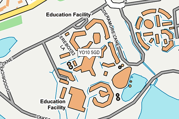
YO10 5GD is located in the Hull Road electoral ward, within the unitary authority of York and the English Parliamentary constituency of York Outer. The Sub Integrated Care Board (ICB) Location is NHS Humber and North Yorkshire ICB - 03Q and the police force is North Yorkshire. This postcode has been in use since November 2010.


GetTheData
Source: OS OpenMap – Local (Ordnance Survey)
Source: OS VectorMap District (Ordnance Survey)
Licence: Open Government Licence (requires attribution)
| Easting | 463663 |
| Northing | 450628 |
| Latitude | 53.947848 |
| Longitude | -1.031494 |
GetTheData
Source: Open Postcode Geo
Licence: Open Government Licence
| Country | England |
| Postcode District | YO10 |
➜ See where YO10 is on a map ➜ Where is York? | |
GetTheData
Source: Land Registry Price Paid Data
Licence: Open Government Licence
Elevation or altitude of YO10 5GD as distance above sea level:
| Metres | Feet | |
|---|---|---|
| Elevation | 10m | 33ft |
Elevation is measured from the approximate centre of the postcode, to the nearest point on an OS contour line from OS Terrain 50, which has contour spacing of ten vertical metres.
➜ How high above sea level am I? Find the elevation of your current position using your device's GPS.
GetTheData
Source: Open Postcode Elevation
Licence: Open Government Licence
| Ward | Hull Road |
| Constituency | York Outer |
GetTheData
Source: ONS Postcode Database
Licence: Open Government Licence
| Ron Cooke Hub (Lakeside Way) | University Of York | 213m |
| Theatre Film & Television (Lakeside Way) | University Of York | 214m |
| Theatre Film & Television (Lakeside Way) | University Of York | 218m |
| Ron Cooke Hub (Lakeside Way) | University Of York | 237m |
| Heslington East Stop B (Transport Interchange) | University Of York | 237m |
| York Station | 4.2km |
GetTheData
Source: NaPTAN
Licence: Open Government Licence
GetTheData
Source: ONS Postcode Database
Licence: Open Government Licence


➜ Get more ratings from the Food Standards Agency
GetTheData
Source: Food Standards Agency
Licence: FSA terms & conditions
| Last Collection | |||
|---|---|---|---|
| Location | Mon-Fri | Sat | Distance |
| Badger Hill | 17:30 | 12:00 | 508m |
| Heslington Court | 17:45 | 12:15 | 735m |
| 9 Tranby Avenue Osbaldwick | 17:30 | 12:00 | 753m |
GetTheData
Source: Dracos
Licence: Creative Commons Attribution-ShareAlike
The below table lists the International Territorial Level (ITL) codes (formerly Nomenclature of Territorial Units for Statistics (NUTS) codes) and Local Administrative Units (LAU) codes for YO10 5GD:
| ITL 1 Code | Name |
|---|---|
| TLE | Yorkshire and The Humber |
| ITL 2 Code | Name |
| TLE2 | North Yorkshire |
| ITL 3 Code | Name |
| TLE21 | York |
| LAU 1 Code | Name |
| E06000014 | York |
GetTheData
Source: ONS Postcode Directory
Licence: Open Government Licence
The below table lists the Census Output Area (OA), Lower Layer Super Output Area (LSOA), and Middle Layer Super Output Area (MSOA) for YO10 5GD:
| Code | Name | |
|---|---|---|
| OA | E00170124 | |
| LSOA | E01013378 | York 023B |
| MSOA | E02002794 | York 023 |
GetTheData
Source: ONS Postcode Directory
Licence: Open Government Licence
| YO10 5JL | Field Lane | 326m |
| YO10 5HN | Badgerwood Walk | 349m |
| YO10 5JB | Eastfield Crescent | 361m |
| YO10 5HZ | Eastfield Crescent | 406m |
| YO10 5HL | Deramore Drive | 434m |
| YO10 5HP | Deramore Drive | 456m |
| YO10 5HU | Brentwood Crescent | 484m |
| YO10 5HW | Deramore Drive | 497m |
| YO10 5JA | Eastfield Court | 499m |
| YO10 5HJ | Foxthorn Paddock | 514m |
GetTheData
Source: Open Postcode Geo; Land Registry Price Paid Data
Licence: Open Government Licence