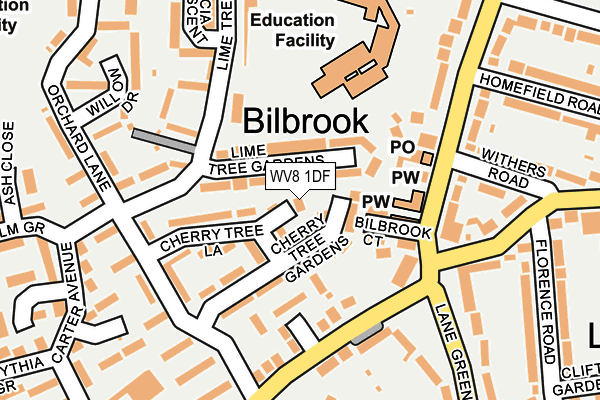
WV8 1DF is located in the Bilbrook electoral ward, within the local authority district of South Staffordshire and the English Parliamentary constituency of South Staffordshire. The Sub Integrated Care Board (ICB) Location is NHS Staffordshire and Stoke-on-Trent ICB - 05Q and the police force is Staffordshire. This postcode has been in use since June 2017.


GetTheData
Source: OS OpenMap – Local (Ordnance Survey)
Source: OS VectorMap District (Ordnance Survey)
Licence: Open Government Licence (requires attribution)
| Easting | 387781 |
| Northing | 303301 |
| Latitude | 52.627343 |
| Longitude | -2.181947 |
GetTheData
Source: Open Postcode Geo
Licence: Open Government Licence
| Country | England |
| Postcode District | WV8 |
➜ See where WV8 is on a map ➜ Where is Bilbrook? | |
GetTheData
Source: Land Registry Price Paid Data
Licence: Open Government Licence
| Ward | Bilbrook |
| Constituency | South Staffordshire |
GetTheData
Source: ONS Postcode Database
Licence: Open Government Licence
| Church Hall (Bilbrook Road) | Bilbrook | 128m |
| Church Hall (Bilbrook Road) | Bilbrook | 133m |
| The Woodman Ph (Duck Lane) | Bilbrook | 136m |
| The Woodman Ph (Duck Lane) | Bilbrook | 138m |
| Lane Green Road (Pendeford Mill Lane) | Bilbrook | 168m |
| Bilbrook Station | 0.5km |
| Codsall Station | 1.3km |
| Wolverhampton Station | 6.1km |
GetTheData
Source: NaPTAN
Licence: Open Government Licence
| Percentage of properties with Next Generation Access | 100.0% |
| Percentage of properties with Superfast Broadband | 100.0% |
| Percentage of properties with Ultrafast Broadband | 0.0% |
| Percentage of properties with Full Fibre Broadband | 0.0% |
Superfast Broadband is between 30Mbps and 300Mbps
Ultrafast Broadband is > 300Mbps
| Percentage of properties unable to receive 2Mbps | 0.0% |
| Percentage of properties unable to receive 5Mbps | 0.0% |
| Percentage of properties unable to receive 10Mbps | 0.0% |
| Percentage of properties unable to receive 30Mbps | 0.0% |
GetTheData
Source: Ofcom
Licence: Ofcom Terms of Use (requires attribution)
GetTheData
Source: ONS Postcode Database
Licence: Open Government Licence


➜ Get more ratings from the Food Standards Agency
GetTheData
Source: Food Standards Agency
Licence: FSA terms & conditions
| Last Collection | |||
|---|---|---|---|
| Location | Mon-Fri | Sat | Distance |
| Oaken Lane | 17:00 | 12:00 | 164m |
| Elliots Lane | 16:45 | 12:30 | 953m |
| Gunstone | 16:30 | 11:30 | 1,397m |
GetTheData
Source: Dracos
Licence: Creative Commons Attribution-ShareAlike
The below table lists the International Territorial Level (ITL) codes (formerly Nomenclature of Territorial Units for Statistics (NUTS) codes) and Local Administrative Units (LAU) codes for WV8 1DF:
| ITL 1 Code | Name |
|---|---|
| TLG | West Midlands (England) |
| ITL 2 Code | Name |
| TLG2 | Shropshire and Staffordshire |
| ITL 3 Code | Name |
| TLG24 | Staffordshire CC |
| LAU 1 Code | Name |
| E07000196 | South Staffordshire |
GetTheData
Source: ONS Postcode Directory
Licence: Open Government Licence
The below table lists the Census Output Area (OA), Lower Layer Super Output Area (LSOA), and Middle Layer Super Output Area (MSOA) for WV8 1DF:
| Code | Name | |
|---|---|---|
| OA | E00150896 | |
| LSOA | E01029614 | South Staffordshire 008B |
| MSOA | E02006181 | South Staffordshire 008 |
GetTheData
Source: ONS Postcode Directory
Licence: Open Government Licence
| WV8 1NR | Lime Tree Gardens | 26m |
| WV8 1NN | Cherry Tree Gardens | 54m |
| WV8 1NW | Cherry Tree Lane | 79m |
| WV8 1BT | Bilbrook Road | 84m |
| WV8 1NL | Cherry Tree Lane | 97m |
| WV8 1HZ | Duck Lane | 121m |
| WV8 1NP | Lime Tree Road | 148m |
| WV8 1EZ | Bilbrook Road | 154m |
| WV8 1JA | Lane Green Shopping Parade | 161m |
| WV8 1NS | Cedar Grove | 168m |
GetTheData
Source: Open Postcode Geo; Land Registry Price Paid Data
Licence: Open Government Licence