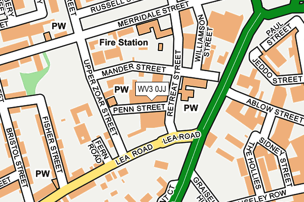
WV3 0JJ is located in the Graiseley electoral ward, within the metropolitan district of Wolverhampton and the English Parliamentary constituency of Wolverhampton South West. The Sub Integrated Care Board (ICB) Location is NHS Black Country ICB - D2P2L and the police force is West Midlands. This postcode has been in use since March 2017.


GetTheData
Source: OS OpenMap – Local (Ordnance Survey)
Source: OS VectorMap District (Ordnance Survey)
Licence: Open Government Licence (requires attribution)
| Easting | 390897 |
| Northing | 297892 |
| Latitude | 52.578779 |
| Longitude | -2.135761 |
GetTheData
Source: Open Postcode Geo
Licence: Open Government Licence
| Country | England |
| Postcode District | WV3 |
➜ See where WV3 is on a map ➜ Where is Wolverhampton? | |
GetTheData
Source: Land Registry Price Paid Data
Licence: Open Government Licence
| Ward | Graiseley |
| Constituency | Wolverhampton South West |
GetTheData
Source: ONS Postcode Database
Licence: Open Government Licence
| Penn Rd (Lea Rd) | Blakenhall | 82m |
| Penn Rd (Lea Rd) | Blakenhall | 120m |
| Lea Rd (Penn Rd) | Blakenhall | 138m |
| Lea Rd (Penn Rd) | Blakenhall | 217m |
| Oaklands Rd (Penn Rd) | Blakenhall | 293m |
| Wolverhampton St George's (Midland Metro Stop) (Bilston St) | Wolverhampton | 979m |
| The Royal (Midland Metro Stop) (Bilston St) | Wolverhampton | 1,261m |
| Wolverhampton Station | 1.5km |
| Coseley Station | 5.1km |
GetTheData
Source: NaPTAN
Licence: Open Government Licence
| Percentage of properties with Next Generation Access | 100.0% |
| Percentage of properties with Superfast Broadband | 100.0% |
| Percentage of properties with Ultrafast Broadband | 0.0% |
| Percentage of properties with Full Fibre Broadband | 0.0% |
Superfast Broadband is between 30Mbps and 300Mbps
Ultrafast Broadband is > 300Mbps
| Percentage of properties unable to receive 2Mbps | 0.0% |
| Percentage of properties unable to receive 5Mbps | 0.0% |
| Percentage of properties unable to receive 10Mbps | 0.0% |
| Percentage of properties unable to receive 30Mbps | 0.0% |
GetTheData
Source: Ofcom
Licence: Ofcom Terms of Use (requires attribution)
GetTheData
Source: ONS Postcode Database
Licence: Open Government Licence


➜ Get more ratings from the Food Standards Agency
GetTheData
Source: Food Standards Agency
Licence: FSA terms & conditions
| Last Collection | |||
|---|---|---|---|
| Location | Mon-Fri | Sat | Distance |
| Great Brickkiln Street | 17:30 | 13:00 | 474m |
| School Street | 17:30 | 12:00 | 573m |
| St Marks Road | 17:30 | 12:00 | 580m |
GetTheData
Source: Dracos
Licence: Creative Commons Attribution-ShareAlike
The below table lists the International Territorial Level (ITL) codes (formerly Nomenclature of Territorial Units for Statistics (NUTS) codes) and Local Administrative Units (LAU) codes for WV3 0JJ:
| ITL 1 Code | Name |
|---|---|
| TLG | West Midlands (England) |
| ITL 2 Code | Name |
| TLG3 | West Midlands |
| ITL 3 Code | Name |
| TLG39 | Wolverhampton |
| LAU 1 Code | Name |
| E08000031 | Wolverhampton |
GetTheData
Source: ONS Postcode Directory
Licence: Open Government Licence
The below table lists the Census Output Area (OA), Lower Layer Super Output Area (LSOA), and Middle Layer Super Output Area (MSOA) for WV3 0JJ:
| Code | Name | |
|---|---|---|
| OA | E00052868 | |
| LSOA | E01010463 | Wolverhampton 020A |
| MSOA | E02002168 | Wolverhampton 020 |
GetTheData
Source: ONS Postcode Directory
Licence: Open Government Licence
| WV3 0JF | Retreat Street | 27m |
| WV3 0JP | Retreat Street | 46m |
| WV3 0JH | Upper Zoar Street | 117m |
| WV3 0LE | Lea Road | 183m |
| WV3 0LX | Lea Gardens | 196m |
| WV3 0DT | Pennant Court | 202m |
| WV2 4EN | Jeddo Street | 204m |
| WV3 0LF | Fisher Street | 209m |
| WV2 4HE | Hollies Industrial Estate | 212m |
| WV3 0PF | Russell Street | 230m |
GetTheData
Source: Open Postcode Geo; Land Registry Price Paid Data
Licence: Open Government Licence