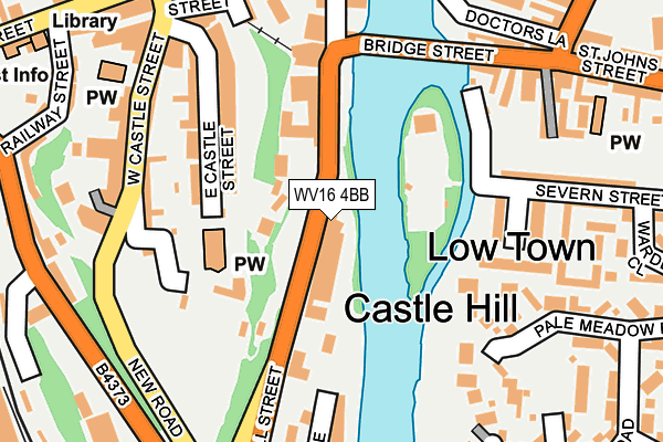
WV16 4BB lies on Underhill Street in Bridgnorth. WV16 4BB is located in the Bridgnorth West and Tasley electoral ward, within the unitary authority of Shropshire and the English Parliamentary constituency of Ludlow. The Sub Integrated Care Board (ICB) Location is NHS Shropshire, Telford and Wrekin ICB - M2L0M and the police force is West Mercia. This postcode has been in use since January 1980.


GetTheData
Source: OS OpenMap – Local (Ordnance Survey)
Source: OS VectorMap District (Ordnance Survey)
Licence: Open Government Licence (requires attribution)
| Easting | 371797 |
| Northing | 292837 |
| Latitude | 52.532677 |
| Longitude | -2.417189 |
GetTheData
Source: Open Postcode Geo
Licence: Open Government Licence
| Street | Underhill Street |
| Town/City | Bridgnorth |
| Country | England |
| Postcode District | WV16 |
➜ See where WV16 is on a map ➜ Where is Bridgnorth? | |
GetTheData
Source: Land Registry Price Paid Data
Licence: Open Government Licence
Elevation or altitude of WV16 4BB as distance above sea level:
| Metres | Feet | |
|---|---|---|
| Elevation | 30m | 98ft |
Elevation is measured from the approximate centre of the postcode, to the nearest point on an OS contour line from OS Terrain 50, which has contour spacing of ten vertical metres.
➜ How high above sea level am I? Find the elevation of your current position using your device's GPS.
GetTheData
Source: Open Postcode Elevation
Licence: Open Government Licence
| Ward | Bridgnorth West And Tasley |
| Constituency | Ludlow |
GetTheData
Source: ONS Postcode Database
Licence: Open Government Licence
40, UNDERHILL STREET, BRIDGNORTH, WV16 4BB 2006 14 JUN £245,000 |
GetTheData
Source: HM Land Registry Price Paid Data
Licence: Contains HM Land Registry data © Crown copyright and database right 2024. This data is licensed under the Open Government Licence v3.0.
| Riverside Wines (Underhill Street) | Castle Hill | 28m |
| Riverside Wines (Underhill Street) | Castle Hill | 38m |
| New Road Jct (West Castle Street) | Castle Hill | 173m |
| Falcon Hotel (Bridge Street) | Low Town | 248m |
| Fosters Arms Ph (Mill Street) | Low Town | 288m |
GetTheData
Source: NaPTAN
Licence: Open Government Licence
| Percentage of properties with Next Generation Access | 100.0% |
| Percentage of properties with Superfast Broadband | 100.0% |
| Percentage of properties with Ultrafast Broadband | 0.0% |
| Percentage of properties with Full Fibre Broadband | 0.0% |
Superfast Broadband is between 30Mbps and 300Mbps
Ultrafast Broadband is > 300Mbps
| Median download speed | 35.6Mbps |
| Average download speed | 41.8Mbps |
| Maximum download speed | 80.00Mbps |
| Median upload speed | 10.0Mbps |
| Average upload speed | 8.7Mbps |
| Maximum upload speed | 20.00Mbps |
| Percentage of properties unable to receive 2Mbps | 0.0% |
| Percentage of properties unable to receive 5Mbps | 0.0% |
| Percentage of properties unable to receive 10Mbps | 0.0% |
| Percentage of properties unable to receive 30Mbps | 0.0% |
GetTheData
Source: Ofcom
Licence: Ofcom Terms of Use (requires attribution)
Estimated total energy consumption in WV16 4BB by fuel type, 2015.
| Consumption (kWh) | 221,285 |
|---|---|
| Meter count | 19 |
| Mean (kWh/meter) | 11,647 |
| Median (kWh/meter) | 10,426 |
| Consumption (kWh) | 127,618 |
|---|---|
| Meter count | 28 |
| Mean (kWh/meter) | 4,558 |
| Median (kWh/meter) | 3,915 |
GetTheData
Source: Postcode level gas estimates: 2015 (experimental)
Source: Postcode level electricity estimates: 2015 (experimental)
Licence: Open Government Licence
GetTheData
Source: ONS Postcode Database
Licence: Open Government Licence


➜ Get more ratings from the Food Standards Agency
GetTheData
Source: Food Standards Agency
Licence: FSA terms & conditions
| Last Collection | |||
|---|---|---|---|
| Location | Mon-Fri | Sat | Distance |
| Underhill Street | 16:45 | 10:30 | 128m |
| West Castle Street | 17:30 | 12:00 | 257m |
| Severn Valley Railway | 16:45 | 09:00 | 322m |
GetTheData
Source: Dracos
Licence: Creative Commons Attribution-ShareAlike
| Risk of WV16 4BB flooding from rivers and sea | Medium |
| ➜ WV16 4BB flood map | |
GetTheData
Source: Open Flood Risk by Postcode
Licence: Open Government Licence
The below table lists the International Territorial Level (ITL) codes (formerly Nomenclature of Territorial Units for Statistics (NUTS) codes) and Local Administrative Units (LAU) codes for WV16 4BB:
| ITL 1 Code | Name |
|---|---|
| TLG | West Midlands (England) |
| ITL 2 Code | Name |
| TLG2 | Shropshire and Staffordshire |
| ITL 3 Code | Name |
| TLG22 | Shropshire |
| LAU 1 Code | Name |
| E06000051 | Shropshire |
GetTheData
Source: ONS Postcode Directory
Licence: Open Government Licence
The below table lists the Census Output Area (OA), Lower Layer Super Output Area (LSOA), and Middle Layer Super Output Area (MSOA) for WV16 4BB:
| Code | Name | |
|---|---|---|
| OA | E00146835 | |
| LSOA | E01028830 | Shropshire 031A |
| MSOA | E02006011 | Shropshire 031 |
GetTheData
Source: ONS Postcode Directory
Licence: Open Government Licence
| WV16 4BY | Underhill Street | 23m |
| WV16 4AQ | St Marys Steps | 77m |
| WV16 4AF | Castle Hill Walk | 88m |
| WV16 4AG | Library Steps | 103m |
| WV16 4AN | East Castle Street | 156m |
| WV15 6BA | Severnside South | 171m |
| WV16 4AL | East Castle Street | 173m |
| WV16 4AD | West Castle Street | 179m |
| WV16 4AB | West Castle Street | 219m |
| WV15 6AF | Bridge Street | 221m |
GetTheData
Source: Open Postcode Geo; Land Registry Price Paid Data
Licence: Open Government Licence