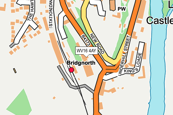
WV16 4AY is located in the Bridgnorth West and Tasley electoral ward, within the unitary authority of Shropshire and the English Parliamentary constituency of Ludlow. The Sub Integrated Care Board (ICB) Location is NHS Shropshire, Telford and Wrekin ICB - M2L0M and the police force is West Mercia. This postcode has been in use since August 2005.


GetTheData
Source: OS OpenMap – Local (Ordnance Survey)
Source: OS VectorMap District (Ordnance Survey)
Licence: Open Government Licence (requires attribution)
| Easting | 371608 |
| Northing | 292640 |
| Latitude | 52.530881 |
| Longitude | -2.419961 |
GetTheData
Source: Open Postcode Geo
Licence: Open Government Licence
| Country | England |
| Postcode District | WV16 |
➜ See where WV16 is on a map ➜ Where is Bridgnorth? | |
GetTheData
Source: Land Registry Price Paid Data
Licence: Open Government Licence
Elevation or altitude of WV16 4AY as distance above sea level:
| Metres | Feet | |
|---|---|---|
| Elevation | 40m | 131ft |
Elevation is measured from the approximate centre of the postcode, to the nearest point on an OS contour line from OS Terrain 50, which has contour spacing of ten vertical metres.
➜ How high above sea level am I? Find the elevation of your current position using your device's GPS.
GetTheData
Source: Open Postcode Elevation
Licence: Open Government Licence
| Ward | Bridgnorth West And Tasley |
| Constituency | Ludlow |
GetTheData
Source: ONS Postcode Database
Licence: Open Government Licence
| King's Loade Jct (Oldbury Road) | Castle Hill | 92m |
| New Road Jct (West Castle Street) | Castle Hill | 242m |
| Severn Valley Railway (Hollybush Road) | Castle Hill | 283m |
| Riverside Wines (Underhill Street) | Castle Hill | 287m |
| Severn Valley Railway (Hollybush Road) | Castle Hill | 301m |
GetTheData
Source: NaPTAN
Licence: Open Government Licence
GetTheData
Source: ONS Postcode Database
Licence: Open Government Licence


➜ Get more ratings from the Food Standards Agency
GetTheData
Source: Food Standards Agency
Licence: FSA terms & conditions
| Last Collection | |||
|---|---|---|---|
| Location | Mon-Fri | Sat | Distance |
| Severn Valley Railway | 16:45 | 09:00 | 49m |
| Oldbury Wells | 16:45 | 10:30 | 368m |
| Underhill Street | 16:45 | 10:30 | 381m |
GetTheData
Source: Dracos
Licence: Creative Commons Attribution-ShareAlike
The below table lists the International Territorial Level (ITL) codes (formerly Nomenclature of Territorial Units for Statistics (NUTS) codes) and Local Administrative Units (LAU) codes for WV16 4AY:
| ITL 1 Code | Name |
|---|---|
| TLG | West Midlands (England) |
| ITL 2 Code | Name |
| TLG2 | Shropshire and Staffordshire |
| ITL 3 Code | Name |
| TLG22 | Shropshire |
| LAU 1 Code | Name |
| E06000051 | Shropshire |
GetTheData
Source: ONS Postcode Directory
Licence: Open Government Licence
The below table lists the Census Output Area (OA), Lower Layer Super Output Area (LSOA), and Middle Layer Super Output Area (MSOA) for WV16 4AY:
| Code | Name | |
|---|---|---|
| OA | E00146835 | |
| LSOA | E01028830 | Shropshire 031A |
| MSOA | E02006011 | Shropshire 031 |
GetTheData
Source: ONS Postcode Directory
Licence: Open Government Licence
| WV16 4DA | Kings Loade | 135m |
| WV16 4AX | Hollybush Road | 155m |
| WV16 4BT | Kings Loade | 170m |
| WV16 4AG | Library Steps | 172m |
| WV16 5DU | Oldbury Road | 177m |
| WV16 5DP | Station Approach | 189m |
| WV16 4AF | Castle Hill Walk | 190m |
| WV16 4BY | Underhill Street | 255m |
| WV16 5JG | The Hawthorns | 259m |
| WV16 4AU | Ebenezer Row | 260m |
GetTheData
Source: Open Postcode Geo; Land Registry Price Paid Data
Licence: Open Government Licence