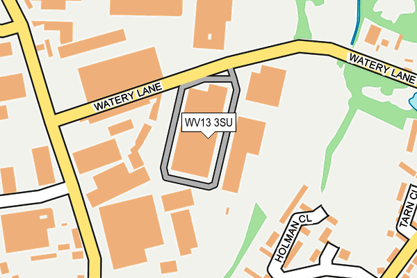
WV13 3SU is located in the Wednesfield South electoral ward, within the metropolitan district of Wolverhampton and the English Parliamentary constituency of Wolverhampton North East. The Sub Integrated Care Board (ICB) Location is NHS Black Country ICB - D2P2L and the police force is West Midlands. This postcode has been in use since January 1980.


GetTheData
Source: OS OpenMap – Local (Ordnance Survey)
Source: OS VectorMap District (Ordnance Survey)
Licence: Open Government Licence (requires attribution)
| Easting | 395016 |
| Northing | 299110 |
| Latitude | 52.589783 |
| Longitude | -2.074995 |
GetTheData
Source: Open Postcode Geo
Licence: Open Government Licence
| Country | England |
| Postcode District | WV13 |
➜ See where WV13 is on a map ➜ Where is Wolverhampton? | |
GetTheData
Source: Land Registry Price Paid Data
Licence: Open Government Licence
Elevation or altitude of WV13 3SU as distance above sea level:
| Metres | Feet | |
|---|---|---|
| Elevation | 130m | 427ft |
Elevation is measured from the approximate centre of the postcode, to the nearest point on an OS contour line from OS Terrain 50, which has contour spacing of ten vertical metres.
➜ How high above sea level am I? Find the elevation of your current position using your device's GPS.
GetTheData
Source: Open Postcode Elevation
Licence: Open Government Licence
| Ward | Wednesfield South |
| Constituency | Wolverhampton North East |
GetTheData
Source: ONS Postcode Database
Licence: Open Government Licence
| Canal Bridge (Watery Lane) | Neachells | 87m |
| Canal Bridge (Watery Lane) | Neachells | 87m |
| Watery Lane (Neachells Lane) | Neachells | 209m |
| Watery Lane (Neachells Lane) | Neachells | 224m |
| Noose Lane (Noose Cres) | Little London | 269m |
| Wolverhampton Station | 3km |
| Coseley Station | 5km |
| Bloxwich Station | 5.3km |
GetTheData
Source: NaPTAN
Licence: Open Government Licence
| Median download speed | 7.2Mbps |
| Average download speed | 6.7Mbps |
| Maximum download speed | 9.04Mbps |
| Median upload speed | 1.0Mbps |
| Average upload speed | 0.9Mbps |
| Maximum upload speed | 1.18Mbps |
GetTheData
Source: Ofcom
Licence: Ofcom Terms of Use (requires attribution)
Estimated total energy consumption in WV13 3SU by fuel type, 2015.
| Consumption (kWh) | 237,182 |
|---|---|
| Meter count | 15 |
| Mean (kWh/meter) | 15,812 |
| Median (kWh/meter) | 10,277 |
GetTheData
Source: Postcode level gas estimates: 2015 (experimental)
Source: Postcode level electricity estimates: 2015 (experimental)
Licence: Open Government Licence
GetTheData
Source: ONS Postcode Database
Licence: Open Government Licence


➜ Get more ratings from the Food Standards Agency
GetTheData
Source: Food Standards Agency
Licence: FSA terms & conditions
| Last Collection | |||
|---|---|---|---|
| Location | Mon-Fri | Sat | Distance |
| Wednesfield Post Office | 17:00 | 12:15 | 1,244m |
| New Road | 17:30 | 12:00 | 1,394m |
| Stafford Street | 17:30 | 12:00 | 1,438m |
GetTheData
Source: Dracos
Licence: Creative Commons Attribution-ShareAlike
The below table lists the International Territorial Level (ITL) codes (formerly Nomenclature of Territorial Units for Statistics (NUTS) codes) and Local Administrative Units (LAU) codes for WV13 3SU:
| ITL 1 Code | Name |
|---|---|
| TLG | West Midlands (England) |
| ITL 2 Code | Name |
| TLG3 | West Midlands |
| ITL 3 Code | Name |
| TLG39 | Wolverhampton |
| LAU 1 Code | Name |
| E08000031 | Wolverhampton |
GetTheData
Source: ONS Postcode Directory
Licence: Open Government Licence
The below table lists the Census Output Area (OA), Lower Layer Super Output Area (LSOA), and Middle Layer Super Output Area (MSOA) for WV13 3SU:
| Code | Name | |
|---|---|---|
| OA | E00053329 | |
| LSOA | E01010564 | Wolverhampton 012C |
| MSOA | E02002160 | Wolverhampton 012 |
GetTheData
Source: ONS Postcode Directory
Licence: Open Government Licence
| WV13 3BL | Holman Close | 177m |
| WV13 3SQ | Neachells Lane | 179m |
| WV13 3BN | Holman Close | 207m |
| WV13 3RP | Neachells Lane | 237m |
| WV13 3BH | Noose Crescent | 258m |
| WV13 3BQ | Beaton Close | 269m |
| WV13 3RG | Neachells Lane | 283m |
| WV13 3SF | Neachells Lane | 288m |
| WV13 3BT | Noose Lane | 316m |
| WV13 3BG | Dooley Close | 318m |
GetTheData
Source: Open Postcode Geo; Land Registry Price Paid Data
Licence: Open Government Licence