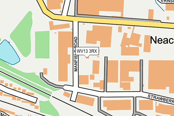
WV13 3RX lies on Manfield Road in Willenhall. WV13 3RX is located in the Wednesfield South electoral ward, within the metropolitan district of Wolverhampton and the English Parliamentary constituency of Wolverhampton North East. The Sub Integrated Care Board (ICB) Location is NHS Black Country ICB - D2P2L and the police force is West Midlands. This postcode has been in use since July 1990.


GetTheData
Source: OS OpenMap – Local (Ordnance Survey)
Source: OS VectorMap District (Ordnance Survey)
Licence: Open Government Licence (requires attribution)
| Easting | 394279 |
| Northing | 299158 |
| Latitude | 52.590207 |
| Longitude | -2.085874 |
GetTheData
Source: Open Postcode Geo
Licence: Open Government Licence
| Street | Manfield Road |
| Town/City | Willenhall |
| Country | England |
| Postcode District | WV13 |
➜ See where WV13 is on a map ➜ Where is Wolverhampton? | |
GetTheData
Source: Land Registry Price Paid Data
Licence: Open Government Licence
Elevation or altitude of WV13 3RX as distance above sea level:
| Metres | Feet | |
|---|---|---|
| Elevation | 140m | 459ft |
Elevation is measured from the approximate centre of the postcode, to the nearest point on an OS contour line from OS Terrain 50, which has contour spacing of ten vertical metres.
➜ How high above sea level am I? Find the elevation of your current position using your device's GPS.
GetTheData
Source: Open Postcode Elevation
Licence: Open Government Licence
| Ward | Wednesfield South |
| Constituency | Wolverhampton North East |
GetTheData
Source: ONS Postcode Database
Licence: Open Government Licence
| Watery Lane (Neachells Lane) | Neachells | 521m |
| Watery Lane (Neachells Lane) | Neachells | 536m |
| Julian Rd (Deans Rd) | Moseley | 552m |
| Julian Rd (Deans Rd) | Moseley | 563m |
| Deansfield School (Deans Rd) | Moseley | 581m |
| Wolverhampton Station | 2.3km |
| Bloxwich North Station | 6.1km |
GetTheData
Source: NaPTAN
Licence: Open Government Licence
GetTheData
Source: ONS Postcode Database
Licence: Open Government Licence


➜ Get more ratings from the Food Standards Agency
GetTheData
Source: Food Standards Agency
Licence: FSA terms & conditions
| Last Collection | |||
|---|---|---|---|
| Location | Mon-Fri | Sat | Distance |
| New Cross Hospital | 17:15 | 13:00 | 836m |
| Wednesfield Post Office | 17:00 | 12:15 | 1,133m |
| Hurstbourne Crescent | 17:30 | 12:30 | 1,250m |
GetTheData
Source: Dracos
Licence: Creative Commons Attribution-ShareAlike
The below table lists the International Territorial Level (ITL) codes (formerly Nomenclature of Territorial Units for Statistics (NUTS) codes) and Local Administrative Units (LAU) codes for WV13 3RX:
| ITL 1 Code | Name |
|---|---|
| TLG | West Midlands (England) |
| ITL 2 Code | Name |
| TLG3 | West Midlands |
| ITL 3 Code | Name |
| TLG39 | Wolverhampton |
| LAU 1 Code | Name |
| E08000031 | Wolverhampton |
GetTheData
Source: ONS Postcode Directory
Licence: Open Government Licence
The below table lists the Census Output Area (OA), Lower Layer Super Output Area (LSOA), and Middle Layer Super Output Area (MSOA) for WV13 3RX:
| Code | Name | |
|---|---|---|
| OA | E00053329 | |
| LSOA | E01010564 | Wolverhampton 012C |
| MSOA | E02002160 | Wolverhampton 012 |
GetTheData
Source: ONS Postcode Directory
Licence: Open Government Licence
| WV13 3SW | Planetary Road | 93m |
| WV1 2BN | Denmore Gardens | 315m |
| WV13 3YA | Key Industrial Park | 341m |
| WV1 2BW | Denmore Gardens | 345m |
| WV1 2AJ | Helming Drive | 346m |
| WV1 2AH | Helming Drive | 347m |
| WV1 2BP | Denmore Gardens | 362m |
| WV1 2AU | Bewdley Drive | 436m |
| WV1 2BG | Rowlands Avenue | 456m |
| WV13 3SF | Neachells Lane | 459m |
GetTheData
Source: Open Postcode Geo; Land Registry Price Paid Data
Licence: Open Government Licence