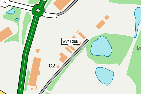
WV11 2BE lies on Hilton Main Industrial Estate in Essington, Wolverhampton. WV11 2BE is located in the Featherstone, Sharehill & Saredon electoral ward, within the local authority district of South Staffordshire and the English Parliamentary constituency of South Staffordshire. The Sub Integrated Care Board (ICB) Location is NHS Staffordshire and Stoke-on-Trent ICB - 05Q and the police force is Staffordshire. This postcode has been in use since March 1982.


GetTheData
Source: OS OpenMap – Local (Ordnance Survey)
Source: OS VectorMap District (Ordnance Survey)
Licence: Open Government Licence (requires attribution)
| Easting | 394123 |
| Northing | 304192 |
| Latitude | 52.635444 |
| Longitude | -2.088274 |
GetTheData
Source: Open Postcode Geo
Licence: Open Government Licence
| Street | Hilton Main Industrial Estate |
| Locality | Essington |
| Town/City | Wolverhampton |
| Country | England |
| Postcode District | WV11 |
➜ See where WV11 is on a map | |
GetTheData
Source: Land Registry Price Paid Data
Licence: Open Government Licence
Elevation or altitude of WV11 2BE as distance above sea level:
| Metres | Feet | |
|---|---|---|
| Elevation | 150m | 492ft |
Elevation is measured from the approximate centre of the postcode, to the nearest point on an OS contour line from OS Terrain 50, which has contour spacing of ten vertical metres.
➜ How high above sea level am I? Find the elevation of your current position using your device's GPS.
GetTheData
Source: Open Postcode Elevation
Licence: Open Government Licence
| Ward | Featherstone, Sharehill & Saredon |
| Constituency | South Staffordshire |
GetTheData
Source: ONS Postcode Database
Licence: Open Government Licence
| Hilton Services (Cannock Road) | Featherstone | 196m |
| Hilton Services (Cannock Road) | Featherstone | 226m |
| Garage (Cannock Road) | Westcroft | 489m |
| Garage (Cannock Road) | Westcroft | 503m |
| 91 Cannock Road (Cannock Road) | Westcroft | 714m |
| Bloxwich North Station | 4.9km |
| Landywood Station | 5.1km |
GetTheData
Source: NaPTAN
Licence: Open Government Licence
| Median download speed | 64.6Mbps |
| Average download speed | 59.2Mbps |
| Maximum download speed | 79.39Mbps |
| Median upload speed | 15.0Mbps |
| Average upload speed | 14.4Mbps |
| Maximum upload speed | 20.00Mbps |
GetTheData
Source: Ofcom
Licence: Ofcom Terms of Use (requires attribution)
GetTheData
Source: ONS Postcode Database
Licence: Open Government Licence


➜ Get more ratings from the Food Standards Agency
GetTheData
Source: Food Standards Agency
Licence: FSA terms & conditions
| Last Collection | |||
|---|---|---|---|
| Location | Mon-Fri | Sat | Distance |
| St Annes Road | 17:00 | 13:00 | 1,418m |
| Abbeyfield Road | 17:00 | 12:30 | 1,473m |
| Underhill Lane | 16:45 | 12:45 | 1,638m |
GetTheData
Source: Dracos
Licence: Creative Commons Attribution-ShareAlike
The below table lists the International Territorial Level (ITL) codes (formerly Nomenclature of Territorial Units for Statistics (NUTS) codes) and Local Administrative Units (LAU) codes for WV11 2BE:
| ITL 1 Code | Name |
|---|---|
| TLG | West Midlands (England) |
| ITL 2 Code | Name |
| TLG2 | Shropshire and Staffordshire |
| ITL 3 Code | Name |
| TLG24 | Staffordshire CC |
| LAU 1 Code | Name |
| E07000196 | South Staffordshire |
GetTheData
Source: ONS Postcode Directory
Licence: Open Government Licence
The below table lists the Census Output Area (OA), Lower Layer Super Output Area (LSOA), and Middle Layer Super Output Area (MSOA) for WV11 2BE:
| Code | Name | |
|---|---|---|
| OA | E00151007 | |
| LSOA | E01029635 | South Staffordshire 007D |
| MSOA | E02006180 | South Staffordshire 007 |
GetTheData
Source: ONS Postcode Directory
Licence: Open Government Licence
| WV10 8QU | Cannock Road | 531m |
| WV10 8QT | Cannock Road | 653m |
| WV10 7AA | Cannock Road | 785m |
| WV10 7AU | South Crescent | 796m |
| WV10 8QS | Cannock Road | 816m |
| WV10 7AT | The Avenue | 843m |
| WV10 7BG | Brookhouse Close | 871m |
| WV10 7AS | The Avenue | 876m |
| WV10 7AP | Whitgreave Avenue | 904m |
| WV10 7AY | North Crescent | 920m |
GetTheData
Source: Open Postcode Geo; Land Registry Price Paid Data
Licence: Open Government Licence