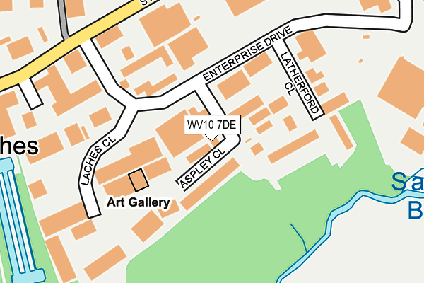
WV10 7DE is located in the Brewood, Coven & Blymhill electoral ward, within the local authority district of South Staffordshire and the English Parliamentary constituency of South Staffordshire. The Sub Integrated Care Board (ICB) Location is NHS Staffordshire and Stoke-on-Trent ICB - 05Q and the police force is Staffordshire. This postcode has been in use since January 1991.


GetTheData
Source: OS OpenMap – Local (Ordnance Survey)
Source: OS VectorMap District (Ordnance Survey)
Licence: Open Government Licence (requires attribution)
| Easting | 392036 |
| Northing | 308284 |
| Latitude | 52.672203 |
| Longitude | -2.119213 |
GetTheData
Source: Open Postcode Geo
Licence: Open Government Licence
| Country | England |
| Postcode District | WV10 |
➜ See where WV10 is on a map ➜ Where is Four Ashes? | |
GetTheData
Source: Land Registry Price Paid Data
Licence: Open Government Licence
Elevation or altitude of WV10 7DE as distance above sea level:
| Metres | Feet | |
|---|---|---|
| Elevation | 100m | 328ft |
Elevation is measured from the approximate centre of the postcode, to the nearest point on an OS contour line from OS Terrain 50, which has contour spacing of ten vertical metres.
➜ How high above sea level am I? Find the elevation of your current position using your device's GPS.
GetTheData
Source: Open Postcode Elevation
Licence: Open Government Licence
| Ward | Brewood, Coven & Blymhill |
| Constituency | South Staffordshire |
GetTheData
Source: ONS Postcode Database
Licence: Open Government Licence
| Four Ashes Inn Ph (Station Drive) | Four Ashes | 713m |
| Station Drive (Stafford Rd) | Four Ashes | 779m |
| Four Ashes Inn Ph (Stafford Rd) | Four Ashes | 779m |
| Station Drive (Stafford Rd) | Four Ashes | 821m |
| Harrows Mobile Home Park (School Lane) | Standeford | 1,073m |
GetTheData
Source: NaPTAN
Licence: Open Government Licence
GetTheData
Source: ONS Postcode Database
Licence: Open Government Licence


➜ Get more ratings from the Food Standards Agency
GetTheData
Source: Food Standards Agency
Licence: FSA terms & conditions
| Last Collection | |||
|---|---|---|---|
| Location | Mon-Fri | Sat | Distance |
| Gailey Wharf | 17:30 | 09:30 | 2,107m |
| St Annes Road | 17:00 | 13:00 | 3,528m |
| Brewood Post Office | 17:15 | 10:45 | 3,707m |
GetTheData
Source: Dracos
Licence: Creative Commons Attribution-ShareAlike
The below table lists the International Territorial Level (ITL) codes (formerly Nomenclature of Territorial Units for Statistics (NUTS) codes) and Local Administrative Units (LAU) codes for WV10 7DE:
| ITL 1 Code | Name |
|---|---|
| TLG | West Midlands (England) |
| ITL 2 Code | Name |
| TLG2 | Shropshire and Staffordshire |
| ITL 3 Code | Name |
| TLG24 | Staffordshire CC |
| LAU 1 Code | Name |
| E07000196 | South Staffordshire |
GetTheData
Source: ONS Postcode Directory
Licence: Open Government Licence
The below table lists the Census Output Area (OA), Lower Layer Super Output Area (LSOA), and Middle Layer Super Output Area (MSOA) for WV10 7DE:
| Code | Name | |
|---|---|---|
| OA | E00150918 | |
| LSOA | E01029616 | South Staffordshire 006A |
| MSOA | E02006179 | South Staffordshire 006 |
GetTheData
Source: ONS Postcode Directory
Licence: Open Government Licence
| WV10 7DY | Latherford Close | 170m |
| WV10 7DZ | Laches Close | 211m |
| WV10 7DG | Station Road | 394m |
| WV10 7DB | Station Road | 401m |
| WV10 7BU | Station Drive | 501m |
| WV10 7DJ | Vicarage Road | 768m |
| WV10 7PZ | Old Stafford Road | 812m |
| WV10 7BN | Stafford Road | 937m |
| WV10 7PH | Old Stafford Road | 981m |
| WV10 7DL | Straight Mile | 1041m |
GetTheData
Source: Open Postcode Geo; Land Registry Price Paid Data
Licence: Open Government Licence