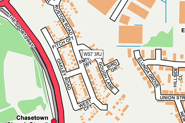
WS7 3RJ is located in the Chasetown electoral ward, within the local authority district of Lichfield and the English Parliamentary constituency of Lichfield. The Sub Integrated Care Board (ICB) Location is NHS Staffordshire and Stoke-on-Trent ICB - 05Q and the police force is Staffordshire. This postcode has been in use since December 2016.


GetTheData
Source: OS OpenMap – Local (Ordnance Survey)
Source: OS VectorMap District (Ordnance Survey)
Licence: Open Government Licence (requires attribution)
| Easting | 404089 |
| Northing | 308502 |
| Latitude | 52.674225 |
| Longitude | -1.940956 |
GetTheData
Source: Open Postcode Geo
Licence: Open Government Licence
| Country | England |
| Postcode District | WS7 |
➜ See where WS7 is on a map ➜ Where is Burntwood? | |
GetTheData
Source: Land Registry Price Paid Data
Licence: Open Government Licence
Elevation or altitude of WS7 3RJ as distance above sea level:
| Metres | Feet | |
|---|---|---|
| Elevation | 160m | 525ft |
Elevation is measured from the approximate centre of the postcode, to the nearest point on an OS contour line from OS Terrain 50, which has contour spacing of ten vertical metres.
➜ How high above sea level am I? Find the elevation of your current position using your device's GPS.
GetTheData
Source: Open Postcode Elevation
Licence: Open Government Licence
| Ward | Chasetown |
| Constituency | Lichfield |
GetTheData
Source: ONS Postcode Database
Licence: Open Government Licence
| Union Street (High Street) | Chasetown | 480m |
| Union Street (High Street) | Chasetown | 485m |
| Chase View (High Street) | Chasetown | 509m |
| Chase View (High Street) | Chasetown | 526m |
| Council Offices (Queen Street) | Chasetown | 643m |
| Hednesford Station | 5.7km |
GetTheData
Source: NaPTAN
Licence: Open Government Licence
| Percentage of properties with Next Generation Access | 100.0% |
| Percentage of properties with Superfast Broadband | 100.0% |
| Percentage of properties with Ultrafast Broadband | 100.0% |
| Percentage of properties with Full Fibre Broadband | 100.0% |
Superfast Broadband is between 30Mbps and 300Mbps
Ultrafast Broadband is > 300Mbps
| Percentage of properties unable to receive 2Mbps | 0.0% |
| Percentage of properties unable to receive 5Mbps | 0.0% |
| Percentage of properties unable to receive 10Mbps | 0.0% |
| Percentage of properties unable to receive 30Mbps | 0.0% |
GetTheData
Source: Ofcom
Licence: Ofcom Terms of Use (requires attribution)
GetTheData
Source: ONS Postcode Database
Licence: Open Government Licence


➜ Get more ratings from the Food Standards Agency
GetTheData
Source: Food Standards Agency
Licence: FSA terms & conditions
| Last Collection | |||
|---|---|---|---|
| Location | Mon-Fri | Sat | Distance |
| Chasetown Post Office | 18:00 | 12:00 | 479m |
| Sankeys Corner Post Office | 18:00 | 11:45 | 896m |
| Safeway | 18:00 | 12:00 | 1,602m |
GetTheData
Source: Dracos
Licence: Creative Commons Attribution-ShareAlike
The below table lists the International Territorial Level (ITL) codes (formerly Nomenclature of Territorial Units for Statistics (NUTS) codes) and Local Administrative Units (LAU) codes for WS7 3RJ:
| ITL 1 Code | Name |
|---|---|
| TLG | West Midlands (England) |
| ITL 2 Code | Name |
| TLG2 | Shropshire and Staffordshire |
| ITL 3 Code | Name |
| TLG24 | Staffordshire CC |
| LAU 1 Code | Name |
| E07000194 | Lichfield |
GetTheData
Source: ONS Postcode Directory
Licence: Open Government Licence
The below table lists the Census Output Area (OA), Lower Layer Super Output Area (LSOA), and Middle Layer Super Output Area (MSOA) for WS7 3RJ:
| Code | Name | |
|---|---|---|
| OA | E00150295 | |
| LSOA | E01029497 | Lichfield 006E |
| MSOA | E02006151 | Lichfield 006 |
GetTheData
Source: ONS Postcode Directory
Licence: Open Government Licence
| WS7 3GA | Elunda Grove | 162m |
| WS7 3XU | Hill Street | 319m |
| WS7 3XX | Union Street | 342m |
| WS7 3XY | New Street | 387m |
| WS7 3XQ | High Street | 467m |
| WS7 3XR | New Street | 479m |
| WS7 3XS | Ivy Close | 483m |
| WS7 3XG | High Street | 486m |
| WS7 3XL | High Street | 488m |
| WS7 3FJ | Willett Avenue | 528m |
GetTheData
Source: Open Postcode Geo; Land Registry Price Paid Data
Licence: Open Government Licence