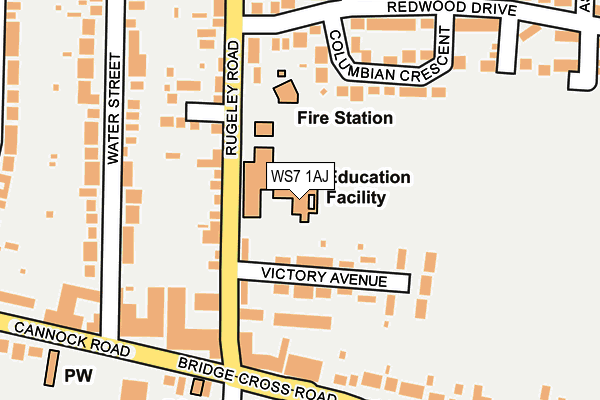
WS7 1AJ is located in the Boney Hay & Central electoral ward, within the local authority district of Lichfield and the English Parliamentary constituency of Lichfield. The Sub Integrated Care Board (ICB) Location is NHS Staffordshire and Stoke-on-Trent ICB - 05Q and the police force is Staffordshire. This postcode has been in use since March 2003.


GetTheData
Source: OS OpenMap – Local (Ordnance Survey)
Source: OS VectorMap District (Ordnance Survey)
Licence: Open Government Licence (requires attribution)
| Easting | 404640 |
| Northing | 309506 |
| Latitude | 52.683230 |
| Longitude | -1.932800 |
GetTheData
Source: Open Postcode Geo
Licence: Open Government Licence
| Country | England |
| Postcode District | WS7 |
➜ See where WS7 is on a map ➜ Where is Burntwood? | |
GetTheData
Source: Land Registry Price Paid Data
Licence: Open Government Licence
Elevation or altitude of WS7 1AJ as distance above sea level:
| Metres | Feet | |
|---|---|---|
| Elevation | 170m | 558ft |
Elevation is measured from the approximate centre of the postcode, to the nearest point on an OS contour line from OS Terrain 50, which has contour spacing of ten vertical metres.
➜ How high above sea level am I? Find the elevation of your current position using your device's GPS.
GetTheData
Source: Open Postcode Elevation
Licence: Open Government Licence
| Ward | Boney Hay & Central |
| Constituency | Lichfield |
GetTheData
Source: ONS Postcode Database
Licence: Open Government Licence
| Victory Avenue (Rugeley Rd) | Burntwood Town Centre | 134m |
| Victory Avenue (Rugeley Rd) | Burntwood Town Centre | 138m |
| Sankey's Corner (Bridge Cross Rd) | Chase Terrace | 195m |
| Sankey's Corner (Bridge Cross Rd) | Chase Terrace | 197m |
| Redwood Drive (Rugeley Road) | Burntwood Town Centre | 216m |
| Hednesford Station | 5.5km |
GetTheData
Source: NaPTAN
Licence: Open Government Licence
GetTheData
Source: ONS Postcode Database
Licence: Open Government Licence

➜ Get more ratings from the Food Standards Agency
GetTheData
Source: Food Standards Agency
Licence: FSA terms & conditions
| Last Collection | |||
|---|---|---|---|
| Location | Mon-Fri | Sat | Distance |
| Sankeys Corner Post Office | 18:00 | 11:45 | 254m |
| Lichfield Road | 16:30 | 10:45 | 824m |
| Chasetown Post Office | 18:00 | 12:00 | 1,268m |
GetTheData
Source: Dracos
Licence: Creative Commons Attribution-ShareAlike
The below table lists the International Territorial Level (ITL) codes (formerly Nomenclature of Territorial Units for Statistics (NUTS) codes) and Local Administrative Units (LAU) codes for WS7 1AJ:
| ITL 1 Code | Name |
|---|---|
| TLG | West Midlands (England) |
| ITL 2 Code | Name |
| TLG2 | Shropshire and Staffordshire |
| ITL 3 Code | Name |
| TLG24 | Staffordshire CC |
| LAU 1 Code | Name |
| E07000194 | Lichfield |
GetTheData
Source: ONS Postcode Directory
Licence: Open Government Licence
The below table lists the Census Output Area (OA), Lower Layer Super Output Area (LSOA), and Middle Layer Super Output Area (MSOA) for WS7 1AJ:
| Code | Name | |
|---|---|---|
| OA | E00150252 | |
| LSOA | E01029490 | Lichfield 009D |
| MSOA | E02006154 | Lichfield 009 |
GetTheData
Source: ONS Postcode Directory
Licence: Open Government Licence
| WS7 1AU | Rugeley Road | 70m |
| WS7 2AL | Victory Avenue | 103m |
| WS7 1AG | Rugeley Road | 109m |
| WS7 2BD | Columbian Crescent | 168m |
| WS7 1AN | Water Street | 181m |
| WS7 2AR | Redwood Drive | 196m |
| WS7 1AW | Water Street | 219m |
| WS7 2BU | Bridge Cross Road | 240m |
| WS7 1JS | Cannock Road | 241m |
| WS7 2AS | Redwood Drive | 244m |
GetTheData
Source: Open Postcode Geo; Land Registry Price Paid Data
Licence: Open Government Licence