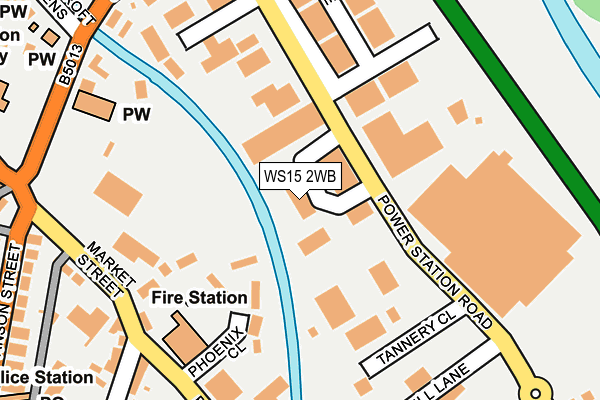
WS15 2WB lies on Trent Business Park in Rugeley. WS15 2WB is located in the Western Springs electoral ward, within the local authority district of Cannock Chase and the English Parliamentary constituency of Cannock Chase. The Sub Integrated Care Board (ICB) Location is NHS Staffordshire and Stoke-on-Trent ICB - 04Y and the police force is Staffordshire. This postcode has been in use since December 1995.


GetTheData
Source: OS OpenMap – Local (Ordnance Survey)
Source: OS VectorMap District (Ordnance Survey)
Licence: Open Government Licence (requires attribution)
| Easting | 404740 |
| Northing | 318419 |
| Latitude | 52.763370 |
| Longitude | -1.931190 |
GetTheData
Source: Open Postcode Geo
Licence: Open Government Licence
| Street | Trent Business Park |
| Town/City | Rugeley |
| Country | England |
| Postcode District | WS15 |
➜ See where WS15 is on a map ➜ Where is Rugeley? | |
GetTheData
Source: Land Registry Price Paid Data
Licence: Open Government Licence
Elevation or altitude of WS15 2WB as distance above sea level:
| Metres | Feet | |
|---|---|---|
| Elevation | 70m | 230ft |
Elevation is measured from the approximate centre of the postcode, to the nearest point on an OS contour line from OS Terrain 50, which has contour spacing of ten vertical metres.
➜ How high above sea level am I? Find the elevation of your current position using your device's GPS.
GetTheData
Source: Open Postcode Elevation
Licence: Open Government Licence
| Ward | Western Springs |
| Constituency | Cannock Chase |
GetTheData
Source: ONS Postcode Database
Licence: Open Government Licence
| Tesco Store (Power Station Road) | Rugeley | 255m |
| Tesco Store (Power Station Road) | Rugeley | 281m |
| Market Street (Anson Street) | Rugeley Town Centre | 296m |
| Chancel School (Wolseley Road) | Rugeley Town Centre | 353m |
| Post Office (Anson St) | Rugeley Town Centre | 367m |
| Rugeley Trent Valley Station | 0.7km |
| Rugeley Town Station | 1.1km |
GetTheData
Source: NaPTAN
Licence: Open Government Licence
GetTheData
Source: ONS Postcode Database
Licence: Open Government Licence


➜ Get more ratings from the Food Standards Agency
GetTheData
Source: Food Standards Agency
Licence: FSA terms & conditions
| Last Collection | |||
|---|---|---|---|
| Location | Mon-Fri | Sat | Distance |
| Armitage Road | 17:30 | 07:30 | 466m |
| Rugeley Post Office | 18:00 | 11:00 | 580m |
| Hill Ridware | 16:45 | 08:30 | 3,277m |
GetTheData
Source: Dracos
Licence: Creative Commons Attribution-ShareAlike
The below table lists the International Territorial Level (ITL) codes (formerly Nomenclature of Territorial Units for Statistics (NUTS) codes) and Local Administrative Units (LAU) codes for WS15 2WB:
| ITL 1 Code | Name |
|---|---|
| TLG | West Midlands (England) |
| ITL 2 Code | Name |
| TLG2 | Shropshire and Staffordshire |
| ITL 3 Code | Name |
| TLG24 | Staffordshire CC |
| LAU 1 Code | Name |
| E07000192 | Cannock Chase |
GetTheData
Source: ONS Postcode Directory
Licence: Open Government Licence
The below table lists the Census Output Area (OA), Lower Layer Super Output Area (LSOA), and Middle Layer Super Output Area (MSOA) for WS15 2WB:
| Code | Name | |
|---|---|---|
| OA | E00149807 | |
| LSOA | E01029404 | Cannock Chase 002E |
| MSOA | E02006119 | Cannock Chase 002 |
GetTheData
Source: ONS Postcode Directory
Licence: Open Government Licence
| WS15 2JY | Phoenix Close | 116m |
| WS15 2YR | Riverside | 171m |
| WS15 2JL | Market Street | 181m |
| WS15 2JN | Bryans Lane | 247m |
| WS15 2JJ | Market Street | 250m |
| WS15 2JH | Market Street | 251m |
| WS15 2HN | Leathermill Lane | 252m |
| WS15 2HE | Station Road | 309m |
| WS15 2BA | Anson Street | 319m |
| WS15 2QH | Wolseley Road | 330m |
GetTheData
Source: Open Postcode Geo; Land Registry Price Paid Data
Licence: Open Government Licence