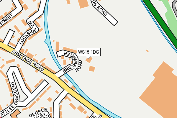
WS15 1DG is located in the Brereton and Ravenhill electoral ward, within the local authority district of Cannock Chase and the English Parliamentary constituency of Cannock Chase. The Sub Integrated Care Board (ICB) Location is NHS Staffordshire and Stoke-on-Trent ICB - 04Y and the police force is Staffordshire. This postcode has been in use since January 1980.


GetTheData
Source: OS OpenMap – Local (Ordnance Survey)
Source: OS VectorMap District (Ordnance Survey)
Licence: Open Government Licence (requires attribution)
| Easting | 405011 |
| Northing | 317514 |
| Latitude | 52.755232 |
| Longitude | -1.927188 |
GetTheData
Source: Open Postcode Geo
Licence: Open Government Licence
| Country | England |
| Postcode District | WS15 |
➜ See where WS15 is on a map ➜ Where is Rugeley? | |
GetTheData
Source: Land Registry Price Paid Data
Licence: Open Government Licence
Elevation or altitude of WS15 1DG as distance above sea level:
| Metres | Feet | |
|---|---|---|
| Elevation | 70m | 230ft |
Elevation is measured from the approximate centre of the postcode, to the nearest point on an OS contour line from OS Terrain 50, which has contour spacing of ten vertical metres.
➜ How high above sea level am I? Find the elevation of your current position using your device's GPS.
GetTheData
Source: Open Postcode Elevation
Licence: Open Government Licence
| Ward | Brereton And Ravenhill |
| Constituency | Cannock Chase |
GetTheData
Source: ONS Postcode Database
Licence: Open Government Licence
| Amazon Distribution Centre (Power Station Road) | Rugeley | 303m |
| Newman Grove (Brereton Main Rd) | Rugeley | 357m |
| Newman Grove (Brereton Main Rd) | Rugeley | 378m |
| Wharf Road (Brereton Main Rd) | Rugeley | 398m |
| Ravenhill Terrace (Brereton Main Road) | Rugeley | 404m |
| Rugeley Town Station | 0.7km |
| Rugeley Trent Valley Station | 1.6km |
GetTheData
Source: NaPTAN
Licence: Open Government Licence
GetTheData
Source: ONS Postcode Database
Licence: Open Government Licence


➜ Get more ratings from the Food Standards Agency
GetTheData
Source: Food Standards Agency
Licence: FSA terms & conditions
| Last Collection | |||
|---|---|---|---|
| Location | Mon-Fri | Sat | Distance |
| Rugeley Post Office | 18:00 | 11:00 | 689m |
| Armitage Road | 17:30 | 07:30 | 864m |
| Hill Ridware | 16:45 | 08:30 | 3,001m |
GetTheData
Source: Dracos
Licence: Creative Commons Attribution-ShareAlike
The below table lists the International Territorial Level (ITL) codes (formerly Nomenclature of Territorial Units for Statistics (NUTS) codes) and Local Administrative Units (LAU) codes for WS15 1DG:
| ITL 1 Code | Name |
|---|---|
| TLG | West Midlands (England) |
| ITL 2 Code | Name |
| TLG2 | Shropshire and Staffordshire |
| ITL 3 Code | Name |
| TLG24 | Staffordshire CC |
| LAU 1 Code | Name |
| E07000192 | Cannock Chase |
GetTheData
Source: ONS Postcode Directory
Licence: Open Government Licence
The below table lists the Census Output Area (OA), Lower Layer Super Output Area (LSOA), and Middle Layer Super Output Area (MSOA) for WS15 1DG:
| Code | Name | |
|---|---|---|
| OA | E00149538 | |
| LSOA | E01029345 | Cannock Chase 003A |
| MSOA | E02006120 | Cannock Chase 003 |
GetTheData
Source: ONS Postcode Directory
Licence: Open Government Licence
| WS15 1EG | Bridgewater Road | 89m |
| WS15 1BZ | Armitage Road | 214m |
| WS15 1DQ | Armitage Road | 226m |
| WS15 1BP | Attlee Crescent | 228m |
| WS15 1NJ | Lockside View | 230m |
| WS15 1DD | George Brealey Close | 262m |
| WS15 1GR | The Lindens | 265m |
| WS15 1DA | Trent View Close | 274m |
| WS15 1DB | Springfield Avenue | 300m |
| WS15 1DE | Armitage Road | 301m |
GetTheData
Source: Open Postcode Geo; Land Registry Price Paid Data
Licence: Open Government Licence