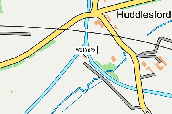
WS13 8PX is located in the Whittington & Streethay electoral ward, within the local authority district of Lichfield and the English Parliamentary constituency of Lichfield. The Sub Integrated Care Board (ICB) Location is NHS Staffordshire and Stoke-on-Trent ICB - 05Q and the police force is Staffordshire. This postcode has been in use since June 1999.


GetTheData
Source: OS OpenMap – Local (Ordnance Survey)
Source: OS VectorMap District (Ordnance Survey)
Licence: Open Government Licence (requires attribution)
| Easting | 415168 |
| Northing | 309500 |
| Latitude | 52.682986 |
| Longitude | -1.777067 |
GetTheData
Source: Open Postcode Geo
Licence: Open Government Licence
| Country | England |
| Postcode District | WS13 |
➜ See where WS13 is on a map ➜ Where is Huddlesford? | |
GetTheData
Source: Land Registry Price Paid Data
Licence: Open Government Licence
Elevation or altitude of WS13 8PX as distance above sea level:
| Metres | Feet | |
|---|---|---|
| Elevation | 60m | 197ft |
Elevation is measured from the approximate centre of the postcode, to the nearest point on an OS contour line from OS Terrain 50, which has contour spacing of ten vertical metres.
➜ How high above sea level am I? Find the elevation of your current position using your device's GPS.
GetTheData
Source: Open Postcode Elevation
Licence: Open Government Licence
| Ward | Whittington & Streethay |
| Constituency | Lichfield |
GetTheData
Source: ONS Postcode Database
Licence: Open Government Licence
| Chapel Lane (Back Lane) | Whittington | 1,219m |
| Church Lane (Back Lane) | Whittington | 1,228m |
| Blacksmith Lane (Back Lane) | Whittington | 1,326m |
| Meadow Croft (Burton Road) | Streethay | 1,353m |
| Meadow Croft (Burton Road) | Streethay | 1,356m |
| Lichfield Trent Valley Station | 1.6km |
| Lichfield Trent Valley High Level Station | 1.6km |
| Lichfield City Station | 3.3km |
GetTheData
Source: NaPTAN
Licence: Open Government Licence
GetTheData
Source: ONS Postcode Database
Licence: Open Government Licence

➜ Get more ratings from the Food Standards Agency
GetTheData
Source: Food Standards Agency
Licence: FSA terms & conditions
| Last Collection | |||
|---|---|---|---|
| Location | Mon-Fri | Sat | Distance |
| Ash Tree Lane | 16:30 | 08:30 | 1,305m |
| Whittington | 17:00 | 10:45 | 1,464m |
| Enterprise | 1,522m | ||
GetTheData
Source: Dracos
Licence: Creative Commons Attribution-ShareAlike
| Risk of WS13 8PX flooding from rivers and sea | Medium |
| ➜ WS13 8PX flood map | |
GetTheData
Source: Open Flood Risk by Postcode
Licence: Open Government Licence
The below table lists the International Territorial Level (ITL) codes (formerly Nomenclature of Territorial Units for Statistics (NUTS) codes) and Local Administrative Units (LAU) codes for WS13 8PX:
| ITL 1 Code | Name |
|---|---|
| TLG | West Midlands (England) |
| ITL 2 Code | Name |
| TLG2 | Shropshire and Staffordshire |
| ITL 3 Code | Name |
| TLG24 | Staffordshire CC |
| LAU 1 Code | Name |
| E07000194 | Lichfield |
GetTheData
Source: ONS Postcode Directory
Licence: Open Government Licence
The below table lists the Census Output Area (OA), Lower Layer Super Output Area (LSOA), and Middle Layer Super Output Area (MSOA) for WS13 8PX:
| Code | Name | |
|---|---|---|
| OA | E00150474 | |
| LSOA | E01029530 | Lichfield 008C |
| MSOA | E02006153 | Lichfield 008 |
GetTheData
Source: ONS Postcode Directory
Licence: Open Government Licence
| WS13 8PY | 242m | |
| WS13 8QD | Park Lane | 1073m |
| WS14 9JP | Cappers Lane | 1114m |
| WS14 9BF | Swan Croft | 1127m |
| WS14 9NS | Burton Road | 1149m |
| WS14 9JZ | Lichfield Road | 1164m |
| WS14 9NL | Back Lane | 1167m |
| WS14 9NU | Swan Road | 1200m |
| WS14 9NP | Burton Road | 1204m |
| WS14 9PL | Huddlesford Lane | 1208m |
GetTheData
Source: Open Postcode Geo; Land Registry Price Paid Data
Licence: Open Government Licence