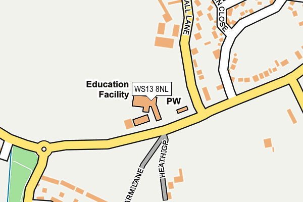
WS13 8NL is located in the Alrewas & Fradley electoral ward, within the local authority district of Lichfield and the English Parliamentary constituency of Lichfield. The Sub Integrated Care Board (ICB) Location is NHS Staffordshire and Stoke-on-Trent ICB - 05D and the police force is Staffordshire. This postcode has been in use since January 1980.


GetTheData
Source: OS OpenMap – Local (Ordnance Survey)
Source: OS VectorMap District (Ordnance Survey)
Licence: Open Government Licence (requires attribution)
| Easting | 415694 |
| Northing | 313453 |
| Latitude | 52.718523 |
| Longitude | -1.769093 |
GetTheData
Source: Open Postcode Geo
Licence: Open Government Licence
| Country | England |
| Postcode District | WS13 |
➜ See where WS13 is on a map ➜ Where is Fradley? | |
GetTheData
Source: Land Registry Price Paid Data
Licence: Open Government Licence
Elevation or altitude of WS13 8NL as distance above sea level:
| Metres | Feet | |
|---|---|---|
| Elevation | 60m | 197ft |
Elevation is measured from the approximate centre of the postcode, to the nearest point on an OS contour line from OS Terrain 50, which has contour spacing of ten vertical metres.
➜ How high above sea level am I? Find the elevation of your current position using your device's GPS.
GetTheData
Source: Open Postcode Elevation
Licence: Open Government Licence
| Ward | Alrewas & Fradley |
| Constituency | Lichfield |
GetTheData
Source: ONS Postcode Database
Licence: Open Government Licence
| Statfold Lane (Church Lane) | Fradley | 142m |
| Statfold Lane (Church Lane) | Fradley | 144m |
| Wyndham Close (Turnbull Road) | Fradley | 251m |
| Wyndham Close (Turnball Road) | Fradley | 266m |
| Church Lane (Long Lane) | Fradley | 451m |
| Lichfield Trent Valley Station | 4.1km |
| Lichfield Trent Valley High Level Station | 4.1km |
| Lichfield City Station | 5.7km |
GetTheData
Source: NaPTAN
Licence: Open Government Licence
GetTheData
Source: ONS Postcode Database
Licence: Open Government Licence


➜ Get more ratings from the Food Standards Agency
GetTheData
Source: Food Standards Agency
Licence: FSA terms & conditions
| Last Collection | |||
|---|---|---|---|
| Location | Mon-Fri | Sat | Distance |
| Harvey Road | 16:15 | 10:15 | 778m |
| Fradley | 17:00 | 09:30 | 1,719m |
| Fradley Junction | 16:00 | 07:30 | 1,739m |
GetTheData
Source: Dracos
Licence: Creative Commons Attribution-ShareAlike
The below table lists the International Territorial Level (ITL) codes (formerly Nomenclature of Territorial Units for Statistics (NUTS) codes) and Local Administrative Units (LAU) codes for WS13 8NL:
| ITL 1 Code | Name |
|---|---|
| TLG | West Midlands (England) |
| ITL 2 Code | Name |
| TLG2 | Shropshire and Staffordshire |
| ITL 3 Code | Name |
| TLG24 | Staffordshire CC |
| LAU 1 Code | Name |
| E07000194 | Lichfield |
GetTheData
Source: ONS Postcode Directory
Licence: Open Government Licence
The below table lists the Census Output Area (OA), Lower Layer Super Output Area (LSOA), and Middle Layer Super Output Area (MSOA) for WS13 8NL:
| Code | Name | |
|---|---|---|
| OA | E00168373 | |
| LSOA | E01029479 | Lichfield 002C |
| MSOA | E02006147 | Lichfield 002 |
GetTheData
Source: ONS Postcode Directory
Licence: Open Government Licence
| WS13 8PB | Church Close | 108m |
| WS13 8PA | Old Hall Lane | 181m |
| WS13 8PH | Heath Gap | 189m |
| WS13 8NZ | Paskin Close | 251m |
| WS13 8UZ | Wyndham Wood Close | 259m |
| WS13 8NY | Statfold Lane | 289m |
| WS13 8NN | Church Lane | 321m |
| WS13 8SB | Shaw Close | 330m |
| WS13 8SD | Bromwich Drive | 357m |
| WS13 8SA | Turner Croft | 392m |
GetTheData
Source: Open Postcode Geo; Land Registry Price Paid Data
Licence: Open Government Licence