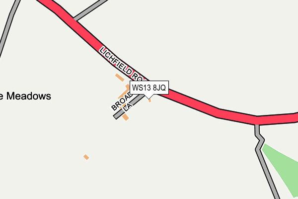
WS13 8JQ lies on Broad Lane in Pipehill, Lichfield. WS13 8JQ is located in the Hammerwich with Wall electoral ward, within the local authority district of Lichfield and the English Parliamentary constituency of Lichfield. The Sub Integrated Care Board (ICB) Location is NHS Staffordshire and Stoke-on-Trent ICB - 05Q and the police force is Staffordshire. This postcode has been in use since November 2002.


GetTheData
Source: OS OpenMap – Local (Ordnance Survey)
Source: OS VectorMap District (Ordnance Survey)
Licence: Open Government Licence (requires attribution)
| Easting | 408918 |
| Northing | 308331 |
| Latitude | 52.672614 |
| Longitude | -1.869550 |
GetTheData
Source: Open Postcode Geo
Licence: Open Government Licence
| Street | Broad Lane |
| Locality | Pipehill |
| Town/City | Lichfield |
| Country | England |
| Postcode District | WS13 |
➜ See where WS13 is on a map ➜ Where is Pipehill? | |
GetTheData
Source: Land Registry Price Paid Data
Licence: Open Government Licence
Elevation or altitude of WS13 8JQ as distance above sea level:
| Metres | Feet | |
|---|---|---|
| Elevation | 120m | 394ft |
Elevation is measured from the approximate centre of the postcode, to the nearest point on an OS contour line from OS Terrain 50, which has contour spacing of ten vertical metres.
➜ How high above sea level am I? Find the elevation of your current position using your device's GPS.
GetTheData
Source: Open Postcode Elevation
Licence: Open Government Licence
| Ward | Hammerwich With Wall |
| Constituency | Lichfield |
GetTheData
Source: ONS Postcode Database
Licence: Open Government Licence
| Broad Lane (Lichfield Road) | Pipehill | 46m |
| Broad Lane (Lichfield Road) | Pipehill | 58m |
| Old Lichfield Road (Lichfield Road) | Pipehill | 175m |
| Old Lichfield Road (Lichfield Road) | Pipehill | 234m |
| Edial Farm (Lichfield Road) | Pipehill | 433m |
| Lichfield City Station | 3.1km |
| Shenstone Station | 4.1km |
| Lichfield Trent Valley High Level Station | 4.9km |
GetTheData
Source: NaPTAN
Licence: Open Government Licence
| Percentage of properties with Next Generation Access | 100.0% |
| Percentage of properties with Superfast Broadband | 100.0% |
| Percentage of properties with Ultrafast Broadband | 100.0% |
| Percentage of properties with Full Fibre Broadband | 100.0% |
Superfast Broadband is between 30Mbps and 300Mbps
Ultrafast Broadband is > 300Mbps
| Percentage of properties unable to receive 2Mbps | 0.0% |
| Percentage of properties unable to receive 5Mbps | 0.0% |
| Percentage of properties unable to receive 10Mbps | 0.0% |
| Percentage of properties unable to receive 30Mbps | 0.0% |
GetTheData
Source: Ofcom
Licence: Ofcom Terms of Use (requires attribution)
GetTheData
Source: ONS Postcode Database
Licence: Open Government Licence


➜ Get more ratings from the Food Standards Agency
GetTheData
Source: Food Standards Agency
Licence: FSA terms & conditions
| Last Collection | |||
|---|---|---|---|
| Location | Mon-Fri | Sat | Distance |
| Waitrose | 16:45 | 11:00 | 1,738m |
| Watling Street | 16:30 | 07:00 | 1,953m |
| Wall | 16:30 | 07:00 | 2,154m |
GetTheData
Source: Dracos
Licence: Creative Commons Attribution-ShareAlike
The below table lists the International Territorial Level (ITL) codes (formerly Nomenclature of Territorial Units for Statistics (NUTS) codes) and Local Administrative Units (LAU) codes for WS13 8JQ:
| ITL 1 Code | Name |
|---|---|
| TLG | West Midlands (England) |
| ITL 2 Code | Name |
| TLG2 | Shropshire and Staffordshire |
| ITL 3 Code | Name |
| TLG24 | Staffordshire CC |
| LAU 1 Code | Name |
| E07000194 | Lichfield |
GetTheData
Source: ONS Postcode Directory
Licence: Open Government Licence
The below table lists the Census Output Area (OA), Lower Layer Super Output Area (LSOA), and Middle Layer Super Output Area (MSOA) for WS13 8JQ:
| Code | Name | |
|---|---|---|
| OA | E00150340 | |
| LSOA | E01029505 | Lichfield 009E |
| MSOA | E02006154 | Lichfield 009 |
GetTheData
Source: ONS Postcode Directory
Licence: Open Government Licence
| WS13 8JR | Lichfield Road | 70m |
| WS13 8JT | Walsall Road | 419m |
| WS13 8JS | Denmark Villas | 469m |
| WS13 8JZ | 515m | |
| WS13 8JU | Walsall Road | 553m |
| WS7 0HZ | Lichfield Road | 570m |
| WS13 8JN | Walsall Road | 599m |
| WS13 8JX | Fosseway Lane | 692m |
| WS14 0DF | Walsall Road | 838m |
| WS7 9EH | Woodhouses Road | 988m |
GetTheData
Source: Open Postcode Geo; Land Registry Price Paid Data
Licence: Open Government Licence