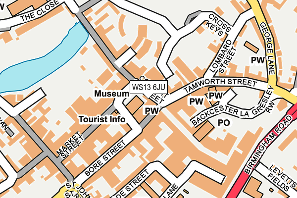
WS13 6JU is located in the Stowe electoral ward, within the local authority district of Lichfield and the English Parliamentary constituency of Lichfield. The Sub Integrated Care Board (ICB) Location is NHS Staffordshire and Stoke-on-Trent ICB - 05Q and the police force is Staffordshire. This postcode has been in use since January 1980.


GetTheData
Source: OS OpenMap – Local (Ordnance Survey)
Source: OS VectorMap District (Ordnance Survey)
Licence: Open Government Licence (requires attribution)
| Easting | 411795 |
| Northing | 309563 |
| Latitude | 52.683635 |
| Longitude | -1.826959 |
GetTheData
Source: Open Postcode Geo
Licence: Open Government Licence
| Country | England |
| Postcode District | WS13 |
➜ See where WS13 is on a map ➜ Where is Lichfield? | |
GetTheData
Source: Land Registry Price Paid Data
Licence: Open Government Licence
Elevation or altitude of WS13 6JU as distance above sea level:
| Metres | Feet | |
|---|---|---|
| Elevation | 80m | 262ft |
Elevation is measured from the approximate centre of the postcode, to the nearest point on an OS contour line from OS Terrain 50, which has contour spacing of ten vertical metres.
➜ How high above sea level am I? Find the elevation of your current position using your device's GPS.
GetTheData
Source: Open Postcode Elevation
Licence: Open Government Licence
| Ward | Stowe |
| Constituency | Lichfield |
GetTheData
Source: ONS Postcode Database
Licence: Open Government Licence
| Library (The Friary) | Lichfield Town Centre | 261m |
| Library (The Friary) | Lichfield Town Centre | 279m |
| Frog Lane (St Johns St) | Lichfield Town Centre | 333m |
| Frog Lane (St John St) | Lichfield Town Centre | 334m |
| The Close (Bird Street) | Christ Church | 347m |
| Lichfield City Station | 0.4km |
| Lichfield Trent Valley High Level Station | 1.8km |
| Lichfield Trent Valley Station | 1.8km |
GetTheData
Source: NaPTAN
Licence: Open Government Licence
GetTheData
Source: ONS Postcode Database
Licence: Open Government Licence


➜ Get more ratings from the Food Standards Agency
GetTheData
Source: Food Standards Agency
Licence: FSA terms & conditions
| Last Collection | |||
|---|---|---|---|
| Location | Mon-Fri | Sat | Distance |
| Conduit Street | 18:00 | 11:00 | 27m |
| Lombard Street | 18:00 | 11:00 | 118m |
| Bakers Lane | 18:30 | 12:15 | 148m |
GetTheData
Source: Dracos
Licence: Creative Commons Attribution-ShareAlike
The below table lists the International Territorial Level (ITL) codes (formerly Nomenclature of Territorial Units for Statistics (NUTS) codes) and Local Administrative Units (LAU) codes for WS13 6JU:
| ITL 1 Code | Name |
|---|---|
| TLG | West Midlands (England) |
| ITL 2 Code | Name |
| TLG2 | Shropshire and Staffordshire |
| ITL 3 Code | Name |
| TLG24 | Staffordshire CC |
| LAU 1 Code | Name |
| E07000194 | Lichfield |
GetTheData
Source: ONS Postcode Directory
Licence: Open Government Licence
The below table lists the Census Output Area (OA), Lower Layer Super Output Area (LSOA), and Middle Layer Super Output Area (MSOA) for WS13 6JU:
| Code | Name | |
|---|---|---|
| OA | E00150441 | |
| LSOA | E01029526 | Lichfield 004E |
| MSOA | E02006149 | Lichfield 004 |
GetTheData
Source: ONS Postcode Directory
Licence: Open Government Licence
| WS13 6JR | Conduit Street | 28m |
| WS13 6JS | Conduit Street | 56m |
| WS13 6JP | Tamworth Street | 66m |
| WS13 6LG | Breadmarket Street | 69m |
| WS13 6LA | Market Street | 87m |
| WS13 6HT | Wade Street | 103m |
| WS13 6JJ | Tamworth Street | 107m |
| WS13 7LA | Quonians Lane | 110m |
| WS13 6AE | Dam Street | 126m |
| WS13 6JH | Backcester Lane | 128m |
GetTheData
Source: Open Postcode Geo; Land Registry Price Paid Data
Licence: Open Government Licence