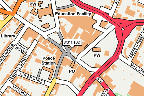
WS11 1DD is located in the Cannock South electoral ward, within the local authority district of Cannock Chase and the English Parliamentary constituency of Cannock Chase. The Sub Integrated Care Board (ICB) Location is NHS Staffordshire and Stoke-on-Trent ICB - 04Y and the police force is Staffordshire. This postcode has been in use since January 1980.


GetTheData
Source: OS OpenMap – Local (Ordnance Survey)
Source: OS VectorMap District (Ordnance Survey)
Licence: Open Government Licence (requires attribution)
| Easting | 398046 |
| Northing | 310151 |
| Latitude | 52.689059 |
| Longitude | -2.030339 |
GetTheData
Source: Open Postcode Geo
Licence: Open Government Licence
| Country | England |
| Postcode District | WS11 |
➜ See where WS11 is on a map ➜ Where is Cannock? | |
GetTheData
Source: Land Registry Price Paid Data
Licence: Open Government Licence
Elevation or altitude of WS11 1DD as distance above sea level:
| Metres | Feet | |
|---|---|---|
| Elevation | 150m | 492ft |
Elevation is measured from the approximate centre of the postcode, to the nearest point on an OS contour line from OS Terrain 50, which has contour spacing of ten vertical metres.
➜ How high above sea level am I? Find the elevation of your current position using your device's GPS.
GetTheData
Source: Open Postcode Elevation
Licence: Open Government Licence
| Ward | Cannock South |
| Constituency | Cannock Chase |
GetTheData
Source: ONS Postcode Database
Licence: Open Government Licence
| Hallcourt Lane (Walsall Road) | Cannock Town Centre | 246m |
| Asda Store (Avon Road) | Cannock Town Centre | 263m |
| Asda Store (Avon Road) | Cannock Town Centre | 302m |
| Cannock Chase Hospital (Brunswick Rd) | Cannock | 319m |
| Hatherton Road (Dartmouth Rd) | Cannock Town Centre | 332m |
| Cannock Station | 0.6km |
| Hednesford Station | 3km |
| Landywood Station | 3.7km |
GetTheData
Source: NaPTAN
Licence: Open Government Licence
GetTheData
Source: ONS Postcode Database
Licence: Open Government Licence


➜ Get more ratings from the Food Standards Agency
GetTheData
Source: Food Standards Agency
Licence: FSA terms & conditions
| Last Collection | |||
|---|---|---|---|
| Location | Mon-Fri | Sat | Distance |
| Bridgetown Post Office | 18:30 | 11:00 | 130m |
| Anson Road | 16:00 | 10:00 | 2,312m |
| Darges Lane | 17:00 | 10:00 | 2,445m |
GetTheData
Source: Dracos
Licence: Creative Commons Attribution-ShareAlike
The below table lists the International Territorial Level (ITL) codes (formerly Nomenclature of Territorial Units for Statistics (NUTS) codes) and Local Administrative Units (LAU) codes for WS11 1DD:
| ITL 1 Code | Name |
|---|---|
| TLG | West Midlands (England) |
| ITL 2 Code | Name |
| TLG2 | Shropshire and Staffordshire |
| ITL 3 Code | Name |
| TLG24 | Staffordshire CC |
| LAU 1 Code | Name |
| E07000192 | Cannock Chase |
GetTheData
Source: ONS Postcode Directory
Licence: Open Government Licence
The below table lists the Census Output Area (OA), Lower Layer Super Output Area (LSOA), and Middle Layer Super Output Area (MSOA) for WS11 1DD:
| Code | Name | |
|---|---|---|
| OA | E00149607 | |
| LSOA | E01029360 | Cannock Chase 012B |
| MSOA | E02006129 | Cannock Chase 012 |
GetTheData
Source: ONS Postcode Directory
Licence: Open Government Licence
| WS11 1AJ | Market Place | 21m |
| WS11 1DE | Church Street | 45m |
| WS11 1BN | High Green | 139m |
| WS11 1WS | Cannock Shopping Centre | 142m |
| WS11 0DL | Mill Street | 168m |
| WS11 1BJ | High Green | 187m |
| WS11 1AH | Wolverhampton Road | 191m |
| WS11 0HE | Walsall Road | 195m |
| WS11 1AP | Wolverhampton Road | 199m |
| WS11 1BE | High Green | 207m |
GetTheData
Source: Open Postcode Geo; Land Registry Price Paid Data
Licence: Open Government Licence