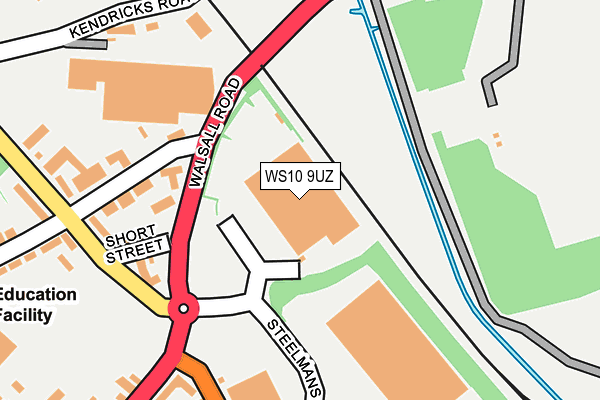
WS10 9UZ lies on Steelmans Road in Wednesbury. WS10 9UZ is located in the Bentley and Darlaston North electoral ward, within the metropolitan district of Walsall and the English Parliamentary constituency of Walsall South. The Sub Integrated Care Board (ICB) Location is NHS Black Country ICB - D2P2L and the police force is West Midlands. This postcode has been in use since December 1999.


GetTheData
Source: OS OpenMap – Local (Ordnance Survey)
Source: OS VectorMap District (Ordnance Survey)
Licence: Open Government Licence (requires attribution)
| Easting | 398979 |
| Northing | 297104 |
| Latitude | 52.571772 |
| Longitude | -2.016492 |
GetTheData
Source: Open Postcode Geo
Licence: Open Government Licence
| Street | Steelmans Road |
| Town/City | Wednesbury |
| Country | England |
| Postcode District | WS10 |
➜ See where WS10 is on a map ➜ Where is Darlaston? | |
GetTheData
Source: Land Registry Price Paid Data
Licence: Open Government Licence
Elevation or altitude of WS10 9UZ as distance above sea level:
| Metres | Feet | |
|---|---|---|
| Elevation | 120m | 394ft |
Elevation is measured from the approximate centre of the postcode, to the nearest point on an OS contour line from OS Terrain 50, which has contour spacing of ten vertical metres.
➜ How high above sea level am I? Find the elevation of your current position using your device's GPS.
GetTheData
Source: Open Postcode Elevation
Licence: Open Government Licence
| Ward | Bentley And Darlaston North |
| Constituency | Walsall South |
GetTheData
Source: ONS Postcode Database
Licence: Open Government Licence
| Station St (Walsall Rd) | Fallings Heath | 240m |
| Station St (Walsall Rd) | Fallings Heath | 256m |
| Park Lane (Walsall Rd) | Fallings Heath | 268m |
| Franchise St (Park Lane) | Fallings Heath | 327m |
| Railway Bridge (Darlaston Rd) | Fallings Heath | 343m |
| Bescot Stadium Station | 2km |
| Walsall Station | 2.6km |
| Tame Bridge Parkway Station | 3.4km |
GetTheData
Source: NaPTAN
Licence: Open Government Licence
GetTheData
Source: ONS Postcode Database
Licence: Open Government Licence


➜ Get more ratings from the Food Standards Agency
GetTheData
Source: Food Standards Agency
Licence: FSA terms & conditions
| Last Collection | |||
|---|---|---|---|
| Location | Mon-Fri | Sat | Distance |
| Aldis Road | 16:00 | 12:00 | 481m |
| Hough Road | 16:00 | 12:00 | 527m |
| Park Lane Post Office | 17:15 | 12:00 | 568m |
GetTheData
Source: Dracos
Licence: Creative Commons Attribution-ShareAlike
The below table lists the International Territorial Level (ITL) codes (formerly Nomenclature of Territorial Units for Statistics (NUTS) codes) and Local Administrative Units (LAU) codes for WS10 9UZ:
| ITL 1 Code | Name |
|---|---|
| TLG | West Midlands (England) |
| ITL 2 Code | Name |
| TLG3 | West Midlands |
| ITL 3 Code | Name |
| TLG38 | Walsall |
| LAU 1 Code | Name |
| E08000030 | Walsall |
GetTheData
Source: ONS Postcode Directory
Licence: Open Government Licence
The below table lists the Census Output Area (OA), Lower Layer Super Output Area (LSOA), and Middle Layer Super Output Area (MSOA) for WS10 9UZ:
| Code | Name | |
|---|---|---|
| OA | E00051854 | |
| LSOA | E01010265 | Walsall 033D |
| MSOA | E02002142 | Walsall 033 |
GetTheData
Source: ONS Postcode Directory
Licence: Open Government Licence
| WS10 9SZ | James Close | 245m |
| WS10 9SE | Park Lane | 245m |
| WS10 8BS | Short Street | 287m |
| WS10 9SH | Walsall Road | 288m |
| WS10 9RS | Wood Street | 308m |
| WS10 8BW | Station Street | 310m |
| WS10 9SQ | Walsall Road | 328m |
| WS10 9SJ | Bangor Villas | 374m |
| WS10 8LZ | Heath Road | 384m |
| WS10 8BJ | Westbourne Road | 389m |
GetTheData
Source: Open Postcode Geo; Land Registry Price Paid Data
Licence: Open Government Licence