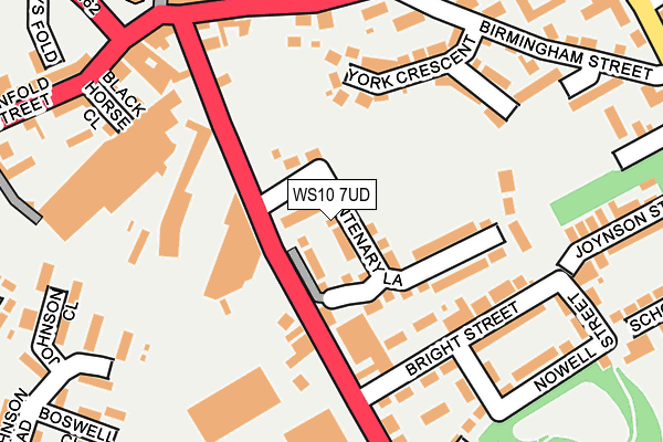
WS10 7UD is located in the Darlaston South electoral ward, within the metropolitan district of Walsall and the English Parliamentary constituency of Walsall South. The Sub Integrated Care Board (ICB) Location is NHS Black Country ICB - D2P2L and the police force is West Midlands. This postcode has been in use since April 2017.


GetTheData
Source: OS OpenMap – Local (Ordnance Survey)
Source: OS VectorMap District (Ordnance Survey)
Licence: Open Government Licence (requires attribution)
| Easting | 397991 |
| Northing | 296448 |
| Latitude | 52.565872 |
| Longitude | -2.031065 |
GetTheData
Source: Open Postcode Geo
Licence: Open Government Licence
| Country | England |
| Postcode District | WS10 |
➜ See where WS10 is on a map ➜ Where is Darlaston? | |
GetTheData
Source: Land Registry Price Paid Data
Licence: Open Government Licence
| Ward | Darlaston South |
| Constituency | Walsall South |
GetTheData
Source: ONS Postcode Database
Licence: Open Government Licence
2021 21 MAY £285,000 |
2020 23 NOV £248,000 |
5, CENTENARY LANE, WEDNESBURY, WS10 7UD 2019 31 MAY £254,995 |
33, CENTENARY LANE, WEDNESBURY, WS10 7UD 2019 29 MAR £251,995 |
67, CENTENARY LANE, WEDNESBURY, WS10 7UD 2018 26 SEP £212,995 |
71, CENTENARY LANE, WEDNESBURY, WS10 7UD 2018 29 JUN £241,995 |
2018 29 JUN £241,995 |
2017 14 JUN £227,950 |
141, CENTENARY LANE, WEDNESBURY, WS10 7UD 2017 26 MAY £227,950 |
GetTheData
Source: HM Land Registry Price Paid Data
Licence: Contains HM Land Registry data © Crown copyright and database right 2025. This data is licensed under the Open Government Licence v3.0.
| Gordon St (Walsall Rd) | Darlaston | 155m |
| Birmingham St (Old Park Rd) | Darlaston | 191m |
| Birmingham St (Old Park Rd) | Darlaston | 208m |
| Gordon St (Old Park Rd) | Darlaston | 218m |
| Walsall Rd (Darlaston Rd) | Darlaston | 224m |
| Bescot Stadium Station | 2.7km |
| Walsall Station | 3.8km |
| Tame Bridge Parkway Station | 4km |
GetTheData
Source: NaPTAN
Licence: Open Government Licence
| Percentage of properties with Next Generation Access | 100.0% |
| Percentage of properties with Superfast Broadband | 100.0% |
| Percentage of properties with Ultrafast Broadband | 100.0% |
| Percentage of properties with Full Fibre Broadband | 98.6% |
Superfast Broadband is between 30Mbps and 300Mbps
Ultrafast Broadband is > 300Mbps
| Median download speed | 100.0Mbps |
| Average download speed | 102.8Mbps |
| Maximum download speed | 350.00Mbps |
Ofcom does not currently provide upload speed data for WS10 7UD. This is because there are less than four broadband connections in this postcode.
| Percentage of properties unable to receive 2Mbps | 0.0% |
| Percentage of properties unable to receive 5Mbps | 0.0% |
| Percentage of properties unable to receive 10Mbps | 0.0% |
| Percentage of properties unable to receive 30Mbps | 0.0% |
GetTheData
Source: Ofcom
Licence: Ofcom Terms of Use (requires attribution)
GetTheData
Source: ONS Postcode Database
Licence: Open Government Licence


➜ Get more ratings from the Food Standards Agency
GetTheData
Source: Food Standards Agency
Licence: FSA terms & conditions
| Last Collection | |||
|---|---|---|---|
| Location | Mon-Fri | Sat | Distance |
| Wednesbury Post Office | 17:30 | 12:00 | 410m |
| Dangerfield Lane | 15:30 | 12:00 | 938m |
| Park Lane Post Office | 17:15 | 12:00 | 1,038m |
GetTheData
Source: Dracos
Licence: Creative Commons Attribution-ShareAlike
The below table lists the International Territorial Level (ITL) codes (formerly Nomenclature of Territorial Units for Statistics (NUTS) codes) and Local Administrative Units (LAU) codes for WS10 7UD:
| ITL 1 Code | Name |
|---|---|
| TLG | West Midlands (England) |
| ITL 2 Code | Name |
| TLG3 | West Midlands |
| ITL 3 Code | Name |
| TLG38 | Walsall |
| LAU 1 Code | Name |
| E08000030 | Walsall |
GetTheData
Source: ONS Postcode Directory
Licence: Open Government Licence
The below table lists the Census Output Area (OA), Lower Layer Super Output Area (LSOA), and Middle Layer Super Output Area (MSOA) for WS10 7UD:
| Code | Name | |
|---|---|---|
| OA | E00052130 | |
| LSOA | E01010311 | Walsall 036C |
| MSOA | E02002145 | Walsall 036 |
GetTheData
Source: ONS Postcode Directory
Licence: Open Government Licence
| WS10 9JJ | York Crescent | 61m |
| WS10 9JQ | Birmingham Street | 95m |
| WS10 9LE | Butcroft Gardens | 147m |
| WS10 9HX | Bright Street | 165m |
| WS10 9HZ | Joynson Street | 168m |
| WS10 9LQ | Old Park Road | 178m |
| WS10 9JG | Old Park Road | 193m |
| WS10 9JR | Walsall Road | 196m |
| WS10 9JT | Walsall Road | 205m |
| WS10 9GA | Nowell Street | 211m |
GetTheData
Source: Open Postcode Geo; Land Registry Price Paid Data
Licence: Open Government Licence