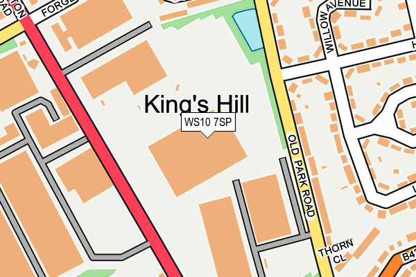
WS10 7SP is located in the Wednesbury North electoral ward, within the metropolitan district of Sandwell and the English Parliamentary constituency of West Bromwich West. The Sub Integrated Care Board (ICB) Location is NHS Black Country ICB - D2P2L and the police force is West Midlands. This postcode has been in use since March 2017.


GetTheData
Source: OS OpenMap – Local (Ordnance Survey)
Source: OS VectorMap District (Ordnance Survey)
Licence: Open Government Licence (requires attribution)
| Easting | 398343 |
| Northing | 295721 |
| Latitude | 52.559338 |
| Longitude | -2.025868 |
GetTheData
Source: Open Postcode Geo
Licence: Open Government Licence
| Country | England |
| Postcode District | WS10 |
➜ See where WS10 is on a map ➜ Where is Wednesbury? | |
GetTheData
Source: Land Registry Price Paid Data
Licence: Open Government Licence
| Ward | Wednesbury North |
| Constituency | West Bromwich West |
GetTheData
Source: ONS Postcode Database
Licence: Open Government Licence
| Kings Hill Industrial Estate (Darlaston Rd) | King's Hill | 158m |
| Blakedown Rd (Darlaston Rd) | Wednesbury | 228m |
| Car Craft (Darlaston Rd) | King's Hill | 238m |
| Car Craft (Darlaston Rd) | King's Hill | 287m |
| Old Park Rd | King's Hill | 322m |
| Wednesbury Parkway (Midland Metro Stop) (Leabrook Rd) | Wednesbury | 1,140m |
| Wednesbury Great Western Street (Metro Stop) (Great Western St) | Wednesbury | 1,204m |
| Bescot Stadium Station | 2.4km |
| Tame Bridge Parkway Station | 3.4km |
| Walsall Station | 3.9km |
GetTheData
Source: NaPTAN
Licence: Open Government Licence
GetTheData
Source: ONS Postcode Database
Licence: Open Government Licence


➜ Get more ratings from the Food Standards Agency
GetTheData
Source: Food Standards Agency
Licence: FSA terms & conditions
| Last Collection | |||
|---|---|---|---|
| Location | Mon-Fri | Sat | Distance |
| Dangerfield Lane | 15:30 | 12:00 | 133m |
| Church Hill | 16:15 | 12:30 | 600m |
| Hobs Road | 17:30 | 12:30 | 862m |
GetTheData
Source: Dracos
Licence: Creative Commons Attribution-ShareAlike
The below table lists the International Territorial Level (ITL) codes (formerly Nomenclature of Territorial Units for Statistics (NUTS) codes) and Local Administrative Units (LAU) codes for WS10 7SP:
| ITL 1 Code | Name |
|---|---|
| TLG | West Midlands (England) |
| ITL 2 Code | Name |
| TLG3 | West Midlands |
| ITL 3 Code | Name |
| TLG37 | Sandwell |
| LAU 1 Code | Name |
| E08000028 | Sandwell |
GetTheData
Source: ONS Postcode Directory
Licence: Open Government Licence
The below table lists the Census Output Area (OA), Lower Layer Super Output Area (LSOA), and Middle Layer Super Output Area (MSOA) for WS10 7SP:
| Code | Name | |
|---|---|---|
| OA | E00051032 | |
| LSOA | E01010089 | Sandwell 001E |
| MSOA | E02002043 | Sandwell 001 |
GetTheData
Source: ONS Postcode Directory
Licence: Open Government Licence
| WS10 9LR | Old Park Industrial Estate | 148m |
| WS10 9LU | Old Park Road | 158m |
| WS10 9LY | Hawthorn Road | 161m |
| WS10 7SH | Kings Hill Business Park | 174m |
| WS10 9NF | Lime Road | 184m |
| WS10 9LX | Old Park Road | 198m |
| WS10 9LN | Goldby Drive | 224m |
| WS10 9LZ | Willow Avenue | 257m |
| WS10 9LT | Melford Mews | 268m |
| WS10 7JA | Short Street | 292m |
GetTheData
Source: Open Postcode Geo; Land Registry Price Paid Data
Licence: Open Government Licence