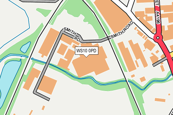
WS10 0PD is located in the Wednesbury South electoral ward, within the metropolitan district of Sandwell and the English Parliamentary constituency of West Bromwich West. The Sub Integrated Care Board (ICB) Location is NHS Black Country ICB - D2P2L and the police force is West Midlands. This postcode has been in use since January 1980.


GetTheData
Source: OS OpenMap – Local (Ordnance Survey)
Source: OS VectorMap District (Ordnance Survey)
Licence: Open Government Licence (requires attribution)
| Easting | 398532 |
| Northing | 294282 |
| Latitude | 52.546402 |
| Longitude | -2.023074 |
GetTheData
Source: Open Postcode Geo
Licence: Open Government Licence
| Country | England |
| Postcode District | WS10 |
➜ See where WS10 is on a map ➜ Where is Wednesbury? | |
GetTheData
Source: Land Registry Price Paid Data
Licence: Open Government Licence
Elevation or altitude of WS10 0PD as distance above sea level:
| Metres | Feet | |
|---|---|---|
| Elevation | 120m | 394ft |
Elevation is measured from the approximate centre of the postcode, to the nearest point on an OS contour line from OS Terrain 50, which has contour spacing of ten vertical metres.
➜ How high above sea level am I? Find the elevation of your current position using your device's GPS.
GetTheData
Source: Open Postcode Elevation
Licence: Open Government Licence
| Ward | Wednesbury South |
| Constituency | West Bromwich West |
GetTheData
Source: ONS Postcode Database
Licence: Open Government Licence
| Woden Rd South (Bridge St) | Wednesbury | 354m |
| Mounts Rd (Bridge St) | Wednesbury | 356m |
| Woden Rd South (Bridge St) | Wednesbury | 365m |
| Russell Street (Holyhead Rd) | Wednesbury | 441m |
| Russell Street (Holyhead Rd) | Wednesbury | 443m |
| Wednesbury Great Western Street (Metro Stop) (Great Western St) | Wednesbury | 254m |
| Wednesbury Parkway (Midland Metro Stop) (Leabrook Rd) | Wednesbury | 616m |
| Bescot Stadium Station | 2.9km |
| Dudley Port Station | 3km |
| Tame Bridge Parkway Station | 3.3km |
GetTheData
Source: NaPTAN
Licence: Open Government Licence
GetTheData
Source: ONS Postcode Database
Licence: Open Government Licence


➜ Get more ratings from the Food Standards Agency
GetTheData
Source: Food Standards Agency
Licence: FSA terms & conditions
| Last Collection | |||
|---|---|---|---|
| Location | Mon-Fri | Sat | Distance |
| Tame Street | 17:45 | 12:00 | 597m |
| Crookhay Lane / Winchester Road | 17:15 | 12:00 | 1,122m |
| Church Hill | 16:15 | 12:30 | 1,191m |
GetTheData
Source: Dracos
Licence: Creative Commons Attribution-ShareAlike
| Risk of WS10 0PD flooding from rivers and sea | High |
| ➜ WS10 0PD flood map | |
GetTheData
Source: Open Flood Risk by Postcode
Licence: Open Government Licence
The below table lists the International Territorial Level (ITL) codes (formerly Nomenclature of Territorial Units for Statistics (NUTS) codes) and Local Administrative Units (LAU) codes for WS10 0PD:
| ITL 1 Code | Name |
|---|---|
| TLG | West Midlands (England) |
| ITL 2 Code | Name |
| TLG3 | West Midlands |
| ITL 3 Code | Name |
| TLG37 | Sandwell |
| LAU 1 Code | Name |
| E08000028 | Sandwell |
GetTheData
Source: ONS Postcode Directory
Licence: Open Government Licence
The below table lists the Census Output Area (OA), Lower Layer Super Output Area (LSOA), and Middle Layer Super Output Area (MSOA) for WS10 0PD:
| Code | Name | |
|---|---|---|
| OA | E00051071 | |
| LSOA | E01010100 | Sandwell 013F |
| MSOA | E02002055 | Sandwell 013 |
GetTheData
Source: ONS Postcode Directory
Licence: Open Government Licence
| WS10 0AS | Potters Lane | 243m |
| WS10 0AN | Bridge Street | 360m |
| WS10 7AZ | Russell Street | 561m |
| WS10 0BB | Burrs Drive | 565m |
| B70 0QP | Tame Street | 567m |
| WS10 7AL | Lower High Street | 580m |
| B70 0TX | Shaw Street | 593m |
| WS10 0BP | Woden Road South | 613m |
| WS10 0DE | River Walk | 634m |
| WS10 9AR | Addison Terrace | 639m |
GetTheData
Source: Open Postcode Geo; Land Registry Price Paid Data
Licence: Open Government Licence