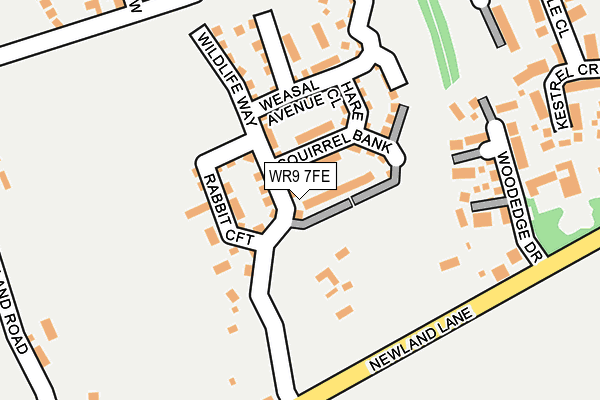
WR9 7FE is located in the Droitwich South East electoral ward, within the local authority district of Wychavon and the English Parliamentary constituency of Mid Worcestershire. The Sub Integrated Care Board (ICB) Location is NHS Herefordshire and Worcestershire ICB - 18C and the police force is West Mercia. This postcode has been in use since March 2017.


GetTheData
Source: OS OpenMap – Local (Ordnance Survey)
Source: OS VectorMap District (Ordnance Survey)
Licence: Open Government Licence (requires attribution)
| Easting | 390513 |
| Northing | 261066 |
| Latitude | 52.247704 |
| Longitude | -2.140369 |
GetTheData
Source: Open Postcode Geo
Licence: Open Government Licence
| Country | England |
| Postcode District | WR9 |
➜ See where WR9 is on a map ➜ Where is Droitwich Spa? | |
GetTheData
Source: Land Registry Price Paid Data
Licence: Open Government Licence
| Ward | Droitwich South East |
| Constituency | Mid Worcestershire |
GetTheData
Source: ONS Postcode Database
Licence: Open Government Licence
5, HEDGEHOG WALK, DROITWICH, WR9 7FE 2017 30 NOV £340,000 |
3, HEDGEHOG WALK, DROITWICH, WR9 7FE 2017 29 SEP £320,000 |
7, HEDGEHOG WALK, DROITWICH, WR9 7FE 2017 22 SEP £320,000 |
1, HEDGEHOG WALK, DROITWICH, WR9 7FE 2017 30 JUN £379,000 |
9, HEDGEHOG WALK, DROITWICH, WR9 7FE 2017 30 MAR £350,000 |
GetTheData
Source: HM Land Registry Price Paid Data
Licence: Contains HM Land Registry data © Crown copyright and database right 2025. This data is licensed under the Open Government Licence v3.0.
| Tagwell Heights (Tagwell Road) | Primsland | 512m |
| Newlandhouse Farm (Newland Common Road) | Newland Common | 575m |
| Clydesdale Road (Tagwell Road) | Primsland | 627m |
| Suffolk Way (Primsland Way) | Primsland | 872m |
| Suffolk Way (Primsland Way) | Primsland | 886m |
| Droitwich Spa Station | 2.6km |
GetTheData
Source: NaPTAN
Licence: Open Government Licence
| Percentage of properties with Next Generation Access | 100.0% |
| Percentage of properties with Superfast Broadband | 100.0% |
| Percentage of properties with Ultrafast Broadband | 100.0% |
| Percentage of properties with Full Fibre Broadband | 100.0% |
Superfast Broadband is between 30Mbps and 300Mbps
Ultrafast Broadband is > 300Mbps
| Percentage of properties unable to receive 2Mbps | 0.0% |
| Percentage of properties unable to receive 5Mbps | 0.0% |
| Percentage of properties unable to receive 10Mbps | 0.0% |
| Percentage of properties unable to receive 30Mbps | 0.0% |
GetTheData
Source: Ofcom
Licence: Ofcom Terms of Use (requires attribution)
GetTheData
Source: ONS Postcode Database
Licence: Open Government Licence


➜ Get more ratings from the Food Standards Agency
GetTheData
Source: Food Standards Agency
Licence: FSA terms & conditions
| Last Collection | |||
|---|---|---|---|
| Location | Mon-Fri | Sat | Distance |
| Newland Common | 16:15 | 07:00 | 360m |
| Jackdaw Lane | 16:45 | 12:00 | 474m |
| Primsland Way | 17:00 | 10:30 | 869m |
GetTheData
Source: Dracos
Licence: Creative Commons Attribution-ShareAlike
The below table lists the International Territorial Level (ITL) codes (formerly Nomenclature of Territorial Units for Statistics (NUTS) codes) and Local Administrative Units (LAU) codes for WR9 7FE:
| ITL 1 Code | Name |
|---|---|
| TLG | West Midlands (England) |
| ITL 2 Code | Name |
| TLG1 | Herefordshire, Worcestershire and Warwickshire |
| ITL 3 Code | Name |
| TLG12 | Worcestershire CC |
| LAU 1 Code | Name |
| E07000238 | Wychavon |
GetTheData
Source: ONS Postcode Directory
Licence: Open Government Licence
The below table lists the Census Output Area (OA), Lower Layer Super Output Area (LSOA), and Middle Layer Super Output Area (MSOA) for WR9 7FE:
| Code | Name | |
|---|---|---|
| OA | E00165067 | |
| LSOA | E01032362 | Wychavon 005A |
| MSOA | E02006752 | Wychavon 005 |
GetTheData
Source: ONS Postcode Directory
Licence: Open Government Licence
| WR9 7JH | Newland Lane | 118m |
| WR9 7GB | Woodedge Drive | 171m |
| WR9 7HH | Kestrel Crescent | 285m |
| WR9 7GD | Cuphill Close | 307m |
| WR9 7HD | Swallow Place | 328m |
| WR9 7JQ | Newland Road | 329m |
| WR9 7HB | Nightingale Close | 337m |
| WR9 7HG | Nightingale Place | 423m |
| WR9 7HE | Jackdaw Lane | 424m |
| WR9 7SU | Clydesdale Rise | 513m |
GetTheData
Source: Open Postcode Geo; Land Registry Price Paid Data
Licence: Open Government Licence