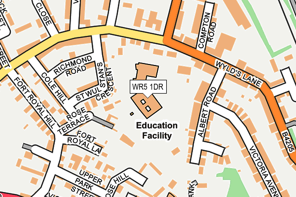
WR5 1DR is located in the Cathedral electoral ward, within the local authority district of Worcester and the English Parliamentary constituency of Worcester. The Sub Integrated Care Board (ICB) Location is NHS Herefordshire and Worcestershire ICB - 18C and the police force is West Mercia. This postcode has been in use since January 1980.


GetTheData
Source: OS OpenMap – Local (Ordnance Survey)
Source: OS VectorMap District (Ordnance Survey)
Licence: Open Government Licence (requires attribution)
| Easting | 385729 |
| Northing | 254443 |
| Latitude | 52.188055 |
| Longitude | -2.210162 |
GetTheData
Source: Open Postcode Geo
Licence: Open Government Licence
| Country | England |
| Postcode District | WR5 |
➜ See where WR5 is on a map ➜ Where is Worcester? | |
GetTheData
Source: Land Registry Price Paid Data
Licence: Open Government Licence
Elevation or altitude of WR5 1DR as distance above sea level:
| Metres | Feet | |
|---|---|---|
| Elevation | 40m | 131ft |
Elevation is measured from the approximate centre of the postcode, to the nearest point on an OS contour line from OS Terrain 50, which has contour spacing of ten vertical metres.
➜ How high above sea level am I? Find the elevation of your current position using your device's GPS.
GetTheData
Source: Open Postcode Elevation
Licence: Open Government Licence
| Ward | Cathedral |
| Constituency | Worcester |
GetTheData
Source: ONS Postcode Database
Licence: Open Government Licence
| Albert Road (B4485) | Worcester | 182m |
| Albert Road (Wyld's Lane (B4485)) | Worcester | 182m |
| Fort Royal Hill | Battenhall | 220m |
| Lea & Perrins Factory (Midland Road) | Worcester | 246m |
| Camp Hill Road (A44) | Battenhall | 293m |
| Worcester Shrub Hill Station | 0.7km |
| Worcester Foregate Street Station | 1.1km |
GetTheData
Source: NaPTAN
Licence: Open Government Licence
GetTheData
Source: ONS Postcode Database
Licence: Open Government Licence


➜ Get more ratings from the Food Standards Agency
GetTheData
Source: Food Standards Agency
Licence: FSA terms & conditions
| Last Collection | |||
|---|---|---|---|
| Location | Mon-Fri | Sat | Distance |
| Fort Royal Hill | 17:15 | 11:30 | 249m |
| London Road | 16:00 | 11:30 | 296m |
| St Dunstans Crescent | 17:15 | 11:30 | 458m |
GetTheData
Source: Dracos
Licence: Creative Commons Attribution-ShareAlike
The below table lists the International Territorial Level (ITL) codes (formerly Nomenclature of Territorial Units for Statistics (NUTS) codes) and Local Administrative Units (LAU) codes for WR5 1DR:
| ITL 1 Code | Name |
|---|---|
| TLG | West Midlands (England) |
| ITL 2 Code | Name |
| TLG1 | Herefordshire, Worcestershire and Warwickshire |
| ITL 3 Code | Name |
| TLG12 | Worcestershire CC |
| LAU 1 Code | Name |
| E07000237 | Worcester |
GetTheData
Source: ONS Postcode Directory
Licence: Open Government Licence
The below table lists the Census Output Area (OA), Lower Layer Super Output Area (LSOA), and Middle Layer Super Output Area (MSOA) for WR5 1DR:
| Code | Name | |
|---|---|---|
| OA | E00164715 | |
| LSOA | E01032292 | Worcester 011B |
| MSOA | E02006744 | Worcester 011 |
GetTheData
Source: ONS Postcode Directory
Licence: Open Government Licence
| WR5 1BU | Walnut Tree Mews | 96m |
| WR5 1EB | Albert Road | 108m |
| WR5 1DQ | St Wulstans Crescent | 109m |
| WR5 1DN | Wylds Lane | 122m |
| WR5 1DX | Wylds Lane | 124m |
| WR5 1DP | Richmond Hill | 137m |
| WR5 1BX | Fort Royal Lane | 146m |
| WR5 1DH | Richmond Road | 153m |
| WR5 1DE | Edward Close | 171m |
| WR5 1EY | Rose Hill | 185m |
GetTheData
Source: Open Postcode Geo; Land Registry Price Paid Data
Licence: Open Government Licence