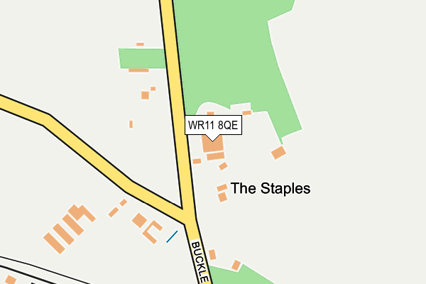
WR11 8QE lies on Brickworks Trading Estate in Honeybourne, Evesham. WR11 8QE is located in the Honeybourne, Pebworth & The Littletons electoral ward, within the local authority district of Wychavon and the English Parliamentary constituency of Mid Worcestershire. The Sub Integrated Care Board (ICB) Location is NHS Herefordshire and Worcestershire ICB - 18C and the police force is West Mercia. This postcode has been in use since December 2001.


GetTheData
Source: OS OpenMap – Local (Ordnance Survey)
Source: OS VectorMap District (Ordnance Survey)
Licence: Open Government Licence (requires attribution)
| Easting | 411528 |
| Northing | 245085 |
| Latitude | 52.103993 |
| Longitude | -1.833096 |
GetTheData
Source: Open Postcode Geo
Licence: Open Government Licence
| Street | Brickworks Trading Estate |
| Locality | Honeybourne |
| Town/City | Evesham |
| Country | England |
| Postcode District | WR11 |
➜ See where WR11 is on a map | |
GetTheData
Source: Land Registry Price Paid Data
Licence: Open Government Licence
Elevation or altitude of WR11 8QE as distance above sea level:
| Metres | Feet | |
|---|---|---|
| Elevation | 60m | 197ft |
Elevation is measured from the approximate centre of the postcode, to the nearest point on an OS contour line from OS Terrain 50, which has contour spacing of ten vertical metres.
➜ How high above sea level am I? Find the elevation of your current position using your device's GPS.
GetTheData
Source: Open Postcode Elevation
Licence: Open Government Licence
| Ward | Honeybourne, Pebworth & The Littletons |
| Constituency | Mid Worcestershire |
GetTheData
Source: ONS Postcode Database
Licence: Open Government Licence
| Railway Station (Gooch Close) | Honeybourne | 403m |
| Stephenson Way Opp Post Box (Station Road) | Honeybourne | 412m |
| Harvard Avenue | Honeybourne | 636m |
| Harvard Avenue | Honeybourne | 651m |
| Westbourne (Dudley Road) | Honeybourne | 670m |
| Honeybourne Station | 0.3km |
GetTheData
Source: NaPTAN
Licence: Open Government Licence
GetTheData
Source: ONS Postcode Database
Licence: Open Government Licence


➜ Get more ratings from the Food Standards Agency
GetTheData
Source: Food Standards Agency
Licence: FSA terms & conditions
| Last Collection | |||
|---|---|---|---|
| Location | Mon-Fri | Sat | Distance |
| Honeybourne Station | 16:15 | 08:30 | 403m |
| Church | 16:15 | 09:30 | 952m |
| Honeybourne P.o. | 16:30 | 10:30 | 1,227m |
GetTheData
Source: Dracos
Licence: Creative Commons Attribution-ShareAlike
The below table lists the International Territorial Level (ITL) codes (formerly Nomenclature of Territorial Units for Statistics (NUTS) codes) and Local Administrative Units (LAU) codes for WR11 8QE:
| ITL 1 Code | Name |
|---|---|
| TLG | West Midlands (England) |
| ITL 2 Code | Name |
| TLG1 | Herefordshire, Worcestershire and Warwickshire |
| ITL 3 Code | Name |
| TLG12 | Worcestershire CC |
| LAU 1 Code | Name |
| E07000238 | Wychavon |
GetTheData
Source: ONS Postcode Directory
Licence: Open Government Licence
The below table lists the Census Output Area (OA), Lower Layer Super Output Area (LSOA), and Middle Layer Super Output Area (MSOA) for WR11 8QE:
| Code | Name | |
|---|---|---|
| OA | E00165201 | |
| LSOA | E01032390 | Wychavon 011A |
| MSOA | E02006758 | Wychavon 011 |
GetTheData
Source: ONS Postcode Directory
Licence: Open Government Licence
| WR11 7GN | Churchward Close | 306m |
| WR11 7GL | Gooch Close | 308m |
| WR11 7GJ | Brunel Way | 328m |
| WR11 7GH | Stephenson Way | 386m |
| WR11 8QQ | Buckle Street | 425m |
| WR11 7AE | Sycamore Drive | 433m |
| WR11 7XR | Dudley Road | 577m |
| WR11 7XT | Perrie Drive | 648m |
| WR11 7XP | Dudley Road | 653m |
| WR11 7XU | Harvard Avenue | 677m |
GetTheData
Source: Open Postcode Geo; Land Registry Price Paid Data
Licence: Open Government Licence