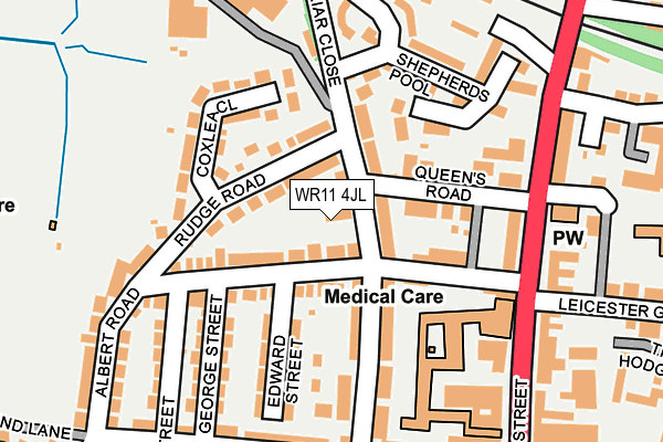
WR11 4JL is located in the Evesham North electoral ward, within the local authority district of Wychavon and the English Parliamentary constituency of Mid Worcestershire. The Sub Integrated Care Board (ICB) Location is NHS Herefordshire and Worcestershire ICB - 18C and the police force is West Mercia. This postcode has been in use since February 2017.


GetTheData
Source: OS OpenMap – Local (Ordnance Survey)
Source: OS VectorMap District (Ordnance Survey)
Licence: Open Government Licence (requires attribution)
| Easting | 403576 |
| Northing | 244253 |
| Latitude | 52.096618 |
| Longitude | -1.949205 |
GetTheData
Source: Open Postcode Geo
Licence: Open Government Licence
| Country | England |
| Postcode District | WR11 |
➜ See where WR11 is on a map ➜ Where is Evesham? | |
GetTheData
Source: Land Registry Price Paid Data
Licence: Open Government Licence
| Ward | Evesham North |
| Constituency | Mid Worcestershire |
GetTheData
Source: ONS Postcode Database
Licence: Open Government Licence
| Railway Station (High Street) | Evesham | 201m |
| Railway Station (High Street) | Evesham | 204m |
| Railway Station Approach (Station Approach Road) | Evesham | 233m |
| Avon Street (High Street) | Evesham | 265m |
| St. Egwins School (Worcester Road) | Greenhill | 343m |
| Evesham Station | 0.2km |
GetTheData
Source: NaPTAN
Licence: Open Government Licence
| Percentage of properties with Next Generation Access | 100.0% |
| Percentage of properties with Superfast Broadband | 100.0% |
| Percentage of properties with Ultrafast Broadband | 0.0% |
| Percentage of properties with Full Fibre Broadband | 0.0% |
Superfast Broadband is between 30Mbps and 300Mbps
Ultrafast Broadband is > 300Mbps
| Median download speed | 19.2Mbps |
| Average download speed | 43.0Mbps |
| Maximum download speed | 80.00Mbps |
| Median upload speed | 1.2Mbps |
| Average upload speed | 8.5Mbps |
| Maximum upload speed | 20.00Mbps |
| Percentage of properties unable to receive 2Mbps | 0.0% |
| Percentage of properties unable to receive 5Mbps | 0.0% |
| Percentage of properties unable to receive 10Mbps | 0.0% |
| Percentage of properties unable to receive 30Mbps | 0.0% |
GetTheData
Source: Ofcom
Licence: Ofcom Terms of Use (requires attribution)
GetTheData
Source: ONS Postcode Database
Licence: Open Government Licence


➜ Get more ratings from the Food Standards Agency
GetTheData
Source: Food Standards Agency
Licence: FSA terms & conditions
| Last Collection | |||
|---|---|---|---|
| Location | Mon-Fri | Sat | Distance |
| Albert Road | 17:15 | 11:00 | 193m |
| High Street Business Box | 18:30 | 213m | |
| Evesham Counter | 18:30 | 12:30 | 220m |
GetTheData
Source: Dracos
Licence: Creative Commons Attribution-ShareAlike
The below table lists the International Territorial Level (ITL) codes (formerly Nomenclature of Territorial Units for Statistics (NUTS) codes) and Local Administrative Units (LAU) codes for WR11 4JL:
| ITL 1 Code | Name |
|---|---|
| TLG | West Midlands (England) |
| ITL 2 Code | Name |
| TLG1 | Herefordshire, Worcestershire and Warwickshire |
| ITL 3 Code | Name |
| TLG12 | Worcestershire CC |
| LAU 1 Code | Name |
| E07000238 | Wychavon |
GetTheData
Source: ONS Postcode Directory
Licence: Open Government Licence
The below table lists the Census Output Area (OA), Lower Layer Super Output Area (LSOA), and Middle Layer Super Output Area (MSOA) for WR11 4JL:
| Code | Name | |
|---|---|---|
| OA | E00165127 | |
| LSOA | E01032378 | Wychavon 014C |
| MSOA | E02006761 | Wychavon 014 |
GetTheData
Source: ONS Postcode Directory
Licence: Open Government Licence
| WR11 4JY | Albert Road | 39m |
| WR11 4JJ | Briar Close | 51m |
| WR11 4JR | Rudge Road | 54m |
| WR11 4JN | Queens Road | 84m |
| WR11 4JX | Albert Road | 99m |
| WR11 4JZ | Albert Road | 112m |
| WR11 4JS | Coxlea Close | 128m |
| WR11 4LF | Edward Street | 146m |
| WR11 4JQ | Briar Close | 149m |
| WR11 4JB | Terrill Court | 153m |
GetTheData
Source: Open Postcode Geo; Land Registry Price Paid Data
Licence: Open Government Licence