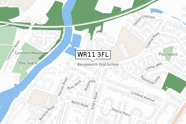
WR11 3FL is located in the Bengeworth electoral ward, within the local authority district of Wychavon and the English Parliamentary constituency of Mid Worcestershire. The Sub Integrated Care Board (ICB) Location is NHS Herefordshire and Worcestershire ICB - 18C and the police force is West Mercia. This postcode has been in use since July 2019.


GetTheData
Source: OS Open Zoomstack (Ordnance Survey)
Licence: Open Government Licence (requires attribution)
Attribution: Contains OS data © Crown copyright and database right 2025
Source: Open Postcode Geo
Licence: Open Government Licence (requires attribution)
Attribution: Contains OS data © Crown copyright and database right 2025; Contains Royal Mail data © Royal Mail copyright and database right 2025; Source: Office for National Statistics licensed under the Open Government Licence v.3.0
| Easting | 404602 |
| Northing | 244156 |
| Latitude | 52.095739 |
| Longitude | -1.934229 |
GetTheData
Source: Open Postcode Geo
Licence: Open Government Licence
| Country | England |
| Postcode District | WR11 |
➜ See where WR11 is on a map ➜ Where is Evesham? | |
GetTheData
Source: Land Registry Price Paid Data
Licence: Open Government Licence
| Ward | Bengeworth |
| Constituency | Mid Worcestershire |
GetTheData
Source: ONS Postcode Database
Licence: Open Government Licence
162, KINGS ROAD, EVESHAM, WR11 3FL 2021 1 SEP £515,000 |
155, KINGS ROAD, EVESHAM, WR11 3FL 2021 29 JUL £475,000 |
153, KINGS ROAD, EVESHAM, WR11 3FL 2021 18 JUN £470,000 |
158, KINGS ROAD, EVESHAM, WR11 3FL 2021 6 JUN £435,000 |
149, KINGS ROAD, EVESHAM, WR11 3FL 2021 19 MAR £399,000 |
147, KINGS ROAD, EVESHAM, WR11 3FL 2021 26 FEB £395,000 |
164, KINGS ROAD, EVESHAM, WR11 3FL 2021 4 FEB £435,000 |
156, KINGS ROAD, EVESHAM, WR11 3FL 2021 29 JAN £468,000 |
151, KINGS ROAD, EVESHAM, WR11 3FL 2020 23 OCT £499,000 |
160, KINGS ROAD, EVESHAM, WR11 3FL 2020 16 OCT £525,000 |
GetTheData
Source: HM Land Registry Price Paid Data
Licence: Contains HM Land Registry data © Crown copyright and database right 2025. This data is licensed under the Open Government Licence v3.0.
| Deacle Place | Bengeworth | 290m |
| Deacle Place | Bengeworth | 291m |
| King's Road (Kings Road) | Bengeworth | 389m |
| King's Road (Kings Road) | Bengeworth | 394m |
| Burford Gardens | Bengeworth | 406m |
| Evesham Station | 0.9km |
GetTheData
Source: NaPTAN
Licence: Open Government Licence
| Percentage of properties with Next Generation Access | 0.0% |
| Percentage of properties with Superfast Broadband | 0.0% |
| Percentage of properties with Ultrafast Broadband | 0.0% |
| Percentage of properties with Full Fibre Broadband | 0.0% |
Superfast Broadband is between 30Mbps and 300Mbps
Ultrafast Broadband is > 300Mbps
| Percentage of properties unable to receive 2Mbps | 0.0% |
| Percentage of properties unable to receive 5Mbps | 0.0% |
| Percentage of properties unable to receive 10Mbps | 0.0% |
| Percentage of properties unable to receive 30Mbps | 0.0% |
GetTheData
Source: Ofcom
Licence: Ofcom Terms of Use (requires attribution)
GetTheData
Source: ONS Postcode Database
Licence: Open Government Licence


➜ Get more ratings from the Food Standards Agency
GetTheData
Source: Food Standards Agency
Licence: FSA terms & conditions
| Last Collection | |||
|---|---|---|---|
| Location | Mon-Fri | Sat | Distance |
| Glencoe Road | 17:30 | 11:00 | 436m |
| Rynal Place | 17:30 | 11:00 | 553m |
| Bengeworth P.o. | 17:15 | 11:00 | 572m |
GetTheData
Source: Dracos
Licence: Creative Commons Attribution-ShareAlike
The below table lists the International Territorial Level (ITL) codes (formerly Nomenclature of Territorial Units for Statistics (NUTS) codes) and Local Administrative Units (LAU) codes for WR11 3FL:
| ITL 1 Code | Name |
|---|---|
| TLG | West Midlands (England) |
| ITL 2 Code | Name |
| TLG1 | Herefordshire, Worcestershire and Warwickshire |
| ITL 3 Code | Name |
| TLG12 | Worcestershire CC |
| LAU 1 Code | Name |
| E07000238 | Wychavon |
GetTheData
Source: ONS Postcode Directory
Licence: Open Government Licence
The below table lists the Census Output Area (OA), Lower Layer Super Output Area (LSOA), and Middle Layer Super Output Area (MSOA) for WR11 3FL:
| Code | Name | |
|---|---|---|
| OA | E00164965 | |
| LSOA | E01032342 | Wychavon 016A |
| MSOA | E02006763 | Wychavon 016 |
GetTheData
Source: ONS Postcode Directory
Licence: Open Government Licence
| WR11 3BJ | Drakes Lea | 56m |
| WR11 3BU | Kings Road | 130m |
| WR11 3EU | Kings Road | 132m |
| WR11 3BQ | Harvey Road | 145m |
| WR11 3BG | Rose Bank | 158m |
| WR11 3AZ | Philipscote | 175m |
| WR11 3BB | Kings Road | 183m |
| WR11 4RP | Robins Walk | 194m |
| WR11 3BT | Kings Road | 214m |
| WR11 4RJ | Robins Corner | 240m |
GetTheData
Source: Open Postcode Geo; Land Registry Price Paid Data
Licence: Open Government Licence