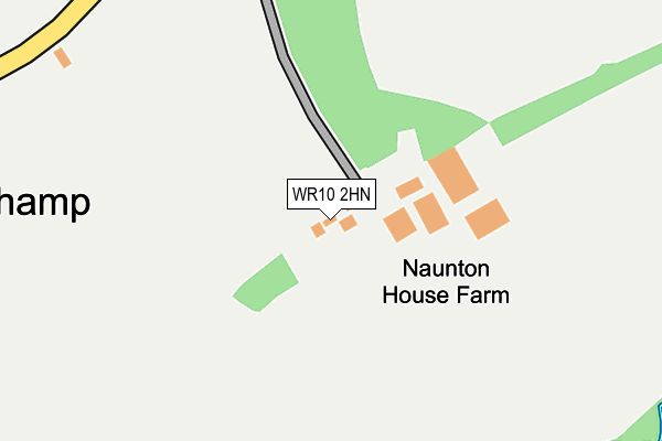
WR10 2HN is located in the Upton Snodsbury electoral ward, within the local authority district of Wychavon and the English Parliamentary constituency of Mid Worcestershire. The Sub Integrated Care Board (ICB) Location is NHS Herefordshire and Worcestershire ICB - 18C and the police force is West Mercia. This postcode has been in use since March 2013.


GetTheData
Source: OS OpenMap – Local (Ordnance Survey)
Source: OS VectorMap District (Ordnance Survey)
Licence: Open Government Licence (requires attribution)
| Easting | 396917 |
| Northing | 252239 |
| Latitude | 52.168407 |
| Longitude | -2.046493 |
GetTheData
Source: Open Postcode Geo
Licence: Open Government Licence
| Country | England |
| Postcode District | WR10 |
➜ See where WR10 is on a map | |
GetTheData
Source: Land Registry Price Paid Data
Licence: Open Government Licence
Elevation or altitude of WR10 2HN as distance above sea level:
| Metres | Feet | |
|---|---|---|
| Elevation | 30m | 98ft |
Elevation is measured from the approximate centre of the postcode, to the nearest point on an OS contour line from OS Terrain 50, which has contour spacing of ten vertical metres.
➜ How high above sea level am I? Find the elevation of your current position using your device's GPS.
GetTheData
Source: Open Postcode Elevation
Licence: Open Government Licence
| Ward | Upton Snodsbury |
| Constituency | Mid Worcestershire |
GetTheData
Source: ONS Postcode Database
Licence: Open Government Licence
| Village Road | Naunton Beauchamp | 627m |
| Church (Village Road) | Naunton Beauchamp | 643m |
| Naunton Beauchamp Road | Naunton Beauchamp | 1,138m |
| Naunton Beauchamp Road (B4082/Naunton Beauchamp Road) | Naunton Beauchamp | 1,156m |
| Baynhall Farm (Abberon Road) | Abberton | 1,762m |
| Pershore Station | 4.5km |
GetTheData
Source: NaPTAN
Licence: Open Government Licence
GetTheData
Source: ONS Postcode Database
Licence: Open Government Licence
| Last Collection | |||
|---|---|---|---|
| Location | Mon-Fri | Sat | Distance |
| Naunton Beauchamp | 16:15 | 08:15 | 554m |
| Church End | 16:00 | 09:00 | 2,122m |
| Bishampton P.o. | 16:00 | 10:00 | 2,174m |
GetTheData
Source: Dracos
Licence: Creative Commons Attribution-ShareAlike
The below table lists the International Territorial Level (ITL) codes (formerly Nomenclature of Territorial Units for Statistics (NUTS) codes) and Local Administrative Units (LAU) codes for WR10 2HN:
| ITL 1 Code | Name |
|---|---|
| TLG | West Midlands (England) |
| ITL 2 Code | Name |
| TLG1 | Herefordshire, Worcestershire and Warwickshire |
| ITL 3 Code | Name |
| TLG12 | Worcestershire CC |
| LAU 1 Code | Name |
| E07000238 | Wychavon |
GetTheData
Source: ONS Postcode Directory
Licence: Open Government Licence
The below table lists the Census Output Area (OA), Lower Layer Super Output Area (LSOA), and Middle Layer Super Output Area (MSOA) for WR10 2HN:
| Code | Name | |
|---|---|---|
| OA | E00165334 | |
| LSOA | E01032416 | Wychavon 008D |
| MSOA | E02006755 | Wychavon 008 |
GetTheData
Source: ONS Postcode Directory
Licence: Open Government Licence
| WR10 2LH | North Piddle Lane | 408m |
| WR10 2LS | Hunts Fold | 453m |
| WR10 2LL | Seaford Lane | 576m |
| WR10 2LQ | 608m | |
| WR10 2LJ | Orchard Lea | 629m |
| WR10 2LG | 1120m | |
| WR7 4NU | Naunton Road | 1469m |
| WR7 4BY | Bishampton Road | 1821m |
| WR10 2LT | Church End | 2077m |
| WR10 2NW | Stanton Fields | 2088m |
GetTheData
Source: Open Postcode Geo; Land Registry Price Paid Data
Licence: Open Government Licence