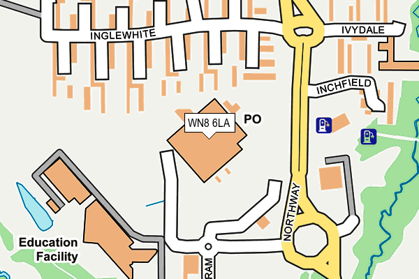
WN8 6LA is located in the Tanhouse & Skelmersdale Town Centre electoral ward, within the local authority district of West Lancashire and the English Parliamentary constituency of West Lancashire. The Sub Integrated Care Board (ICB) Location is NHS Lancashire and South Cumbria ICB - 02G and the police force is Lancashire. This postcode has been in use since December 1996.


GetTheData
Source: OS OpenMap – Local (Ordnance Survey)
Source: OS VectorMap District (Ordnance Survey)
Licence: Open Government Licence (requires attribution)
| Easting | 348557 |
| Northing | 406661 |
| Latitude | 53.554041 |
| Longitude | -2.777975 |
GetTheData
Source: Open Postcode Geo
Licence: Open Government Licence
| Country | England |
| Postcode District | WN8 |
➜ See where WN8 is on a map ➜ Where is Skelmersdale? | |
GetTheData
Source: Land Registry Price Paid Data
Licence: Open Government Licence
Elevation or altitude of WN8 6LA as distance above sea level:
| Metres | Feet | |
|---|---|---|
| Elevation | 60m | 197ft |
Elevation is measured from the approximate centre of the postcode, to the nearest point on an OS contour line from OS Terrain 50, which has contour spacing of ten vertical metres.
➜ How high above sea level am I? Find the elevation of your current position using your device's GPS.
GetTheData
Source: Open Postcode Elevation
Licence: Open Government Licence
| Ward | Tanhouse & Skelmersdale Town Centre |
| Constituency | West Lancashire |
GetTheData
Source: ONS Postcode Database
Licence: Open Government Licence
| Asda (Northway) | Skelmersdale | 52m |
| Northway Asda (Northway) | Skelmersdale | 121m |
| Northway Asda (Northway) | Skelmersdale | 147m |
| Ivybridge (Northway) | Skelmersdale | 258m |
| Inglewhite (Northway) | Skelmersdale | 259m |
| Upholland Station | 3.7km |
| Parbold Station | 4.1km |
| Rainford Station | 4.2km |
GetTheData
Source: NaPTAN
Licence: Open Government Licence
GetTheData
Source: ONS Postcode Database
Licence: Open Government Licence


➜ Get more ratings from the Food Standards Agency
GetTheData
Source: Food Standards Agency
Licence: FSA terms & conditions
| Last Collection | |||
|---|---|---|---|
| Location | Mon-Fri | Sat | Distance |
| Birch Green Road/ Feltons | 16:20 | 11:00 | 513m |
| The Viking | 18:45 | 11:00 | 577m |
| The Viking (Business Box) | 579m | ||
GetTheData
Source: Dracos
Licence: Creative Commons Attribution-ShareAlike
The below table lists the International Territorial Level (ITL) codes (formerly Nomenclature of Territorial Units for Statistics (NUTS) codes) and Local Administrative Units (LAU) codes for WN8 6LA:
| ITL 1 Code | Name |
|---|---|
| TLD | North West (England) |
| ITL 2 Code | Name |
| TLD4 | Lancashire |
| ITL 3 Code | Name |
| TLD47 | Chorley and West Lancashire |
| LAU 1 Code | Name |
| E07000127 | West Lancashire |
GetTheData
Source: ONS Postcode Directory
Licence: Open Government Licence
The below table lists the Census Output Area (OA), Lower Layer Super Output Area (LSOA), and Middle Layer Super Output Area (MSOA) for WN8 6LA:
| Code | Name | |
|---|---|---|
| OA | E00129315 | |
| LSOA | E01025481 | West Lancashire 010C |
| MSOA | E02005313 | West Lancashire 010 |
GetTheData
Source: ONS Postcode Directory
Licence: Open Government Licence
| WN8 6JG | Inglewhite | 111m |
| WN8 6JQ | Inglewhite | 191m |
| WN8 6JE | Inglewhite | 210m |
| WN8 6LP | Inchfield | 248m |
| WN8 6JF | Inglewhite | 253m |
| WN8 6RS | Ivydale | 257m |
| WN8 6JT | Inskip | 277m |
| WN8 6JS | Inskip Court | 285m |
| WN8 6RR | Ivybridge | 336m |
| WN8 6JU | Inskip | 347m |
GetTheData
Source: Open Postcode Geo; Land Registry Price Paid Data
Licence: Open Government Licence