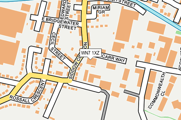
WN7 1XZ is located in the Leigh South electoral ward, within the metropolitan district of Wigan and the English Parliamentary constituency of Leigh. The Sub Integrated Care Board (ICB) Location is NHS Greater Manchester ICB - 02H and the police force is Greater Manchester. This postcode has been in use since December 2001.


GetTheData
Source: OS OpenMap – Local (Ordnance Survey)
Source: OS VectorMap District (Ordnance Survey)
Licence: Open Government Licence (requires attribution)
| Easting | 366279 |
| Northing | 399480 |
| Latitude | 53.490940 |
| Longitude | -2.509710 |
GetTheData
Source: Open Postcode Geo
Licence: Open Government Licence
| Country | England |
| Postcode District | WN7 |
➜ See where WN7 is on a map ➜ Where is Leigh? | |
GetTheData
Source: Land Registry Price Paid Data
Licence: Open Government Licence
Elevation or altitude of WN7 1XZ as distance above sea level:
| Metres | Feet | |
|---|---|---|
| Elevation | 20m | 66ft |
Elevation is measured from the approximate centre of the postcode, to the nearest point on an OS contour line from OS Terrain 50, which has contour spacing of ten vertical metres.
➜ How high above sea level am I? Find the elevation of your current position using your device's GPS.
GetTheData
Source: Open Postcode Elevation
Licence: Open Government Licence
| Ward | Leigh South |
| Constituency | Leigh |
GetTheData
Source: ONS Postcode Database
Licence: Open Government Licence
| Siddow Common/East Bridgewater St (Siddow Common) | Siddow Common | 103m |
| Siddow Common/East Bridgewater St (Siddow Common) | Siddow Common | 106m |
| Hope Carr Rd/Siddow Common (Hope Carr Rd) | Siddow Common | 120m |
| Hope Carr Rd/Siddow Common (Hope Carr Rd) | Siddow Common | 137m |
| Pennington Rd/Rugby Rd (Pennington Rd) | Siddow Common | 240m |
| Atherton Station | 4.7km |
| Hag Fold Station | 4.9km |
GetTheData
Source: NaPTAN
Licence: Open Government Licence
GetTheData
Source: ONS Postcode Database
Licence: Open Government Licence


➜ Get more ratings from the Food Standards Agency
GetTheData
Source: Food Standards Agency
Licence: FSA terms & conditions
| Last Collection | |||
|---|---|---|---|
| Location | Mon-Fri | Sat | Distance |
| Burns Avenue | 17:40 | 11:30 | 464m |
| Leigh Branch Office | 19:15 | 12:30 | 851m |
| 2 Bonneywell Road | 18:15 | 12:00 | 883m |
GetTheData
Source: Dracos
Licence: Creative Commons Attribution-ShareAlike
The below table lists the International Territorial Level (ITL) codes (formerly Nomenclature of Territorial Units for Statistics (NUTS) codes) and Local Administrative Units (LAU) codes for WN7 1XZ:
| ITL 1 Code | Name |
|---|---|
| TLD | North West (England) |
| ITL 2 Code | Name |
| TLD3 | Greater Manchester |
| ITL 3 Code | Name |
| TLD36 | Greater Manchester North West |
| LAU 1 Code | Name |
| E08000010 | Wigan |
GetTheData
Source: ONS Postcode Directory
Licence: Open Government Licence
The below table lists the Census Output Area (OA), Lower Layer Super Output Area (LSOA), and Middle Layer Super Output Area (MSOA) for WN7 1XZ:
| Code | Name | |
|---|---|---|
| OA | E00031918 | |
| LSOA | E01006296 | Wigan 037A |
| MSOA | E02001323 | Wigan 037 |
GetTheData
Source: ONS Postcode Directory
Licence: Open Government Licence
| WN7 3EN | Siddow Common | 94m |
| WN7 3ES | Cecil Street | 124m |
| WN7 3EZ | Rossall Crescent | 130m |
| WN7 3EW | East Bridgewater Street | 130m |
| WN7 3ET | Hope Carr Road | 142m |
| WN7 3HX | Pennington Square | 149m |
| WN7 3EX | Miriam Grove | 154m |
| WN7 3EU | Claycroft Bungalows | 159m |
| WN7 3EP | Edward Street | 178m |
| WN7 3HA | Henry Street | 180m |
GetTheData
Source: Open Postcode Geo; Land Registry Price Paid Data
Licence: Open Government Licence