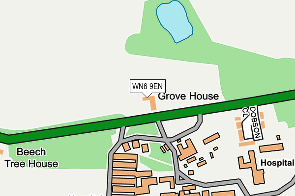
WN6 9EN lies on Hall Lane in Wrightington, Wigan. WN6 9EN is located in the Rural North East electoral ward, within the local authority district of West Lancashire and the English Parliamentary constituency of West Lancashire. The Sub Integrated Care Board (ICB) Location is NHS Lancashire and South Cumbria ICB - 02G and the police force is Lancashire. This postcode has been in use since January 1980.


GetTheData
Source: OS OpenMap – Local (Ordnance Survey)
Source: OS VectorMap District (Ordnance Survey)
Licence: Open Government Licence (requires attribution)
| Easting | 352918 |
| Northing | 410799 |
| Latitude | 53.591642 |
| Longitude | -2.712780 |
GetTheData
Source: Open Postcode Geo
Licence: Open Government Licence
| Street | Hall Lane |
| Locality | Wrightington |
| Town/City | Wigan |
| Country | England |
| Postcode District | WN6 |
➜ See where WN6 is on a map | |
GetTheData
Source: Land Registry Price Paid Data
Licence: Open Government Licence
Elevation or altitude of WN6 9EN as distance above sea level:
| Metres | Feet | |
|---|---|---|
| Elevation | 100m | 328ft |
Elevation is measured from the approximate centre of the postcode, to the nearest point on an OS contour line from OS Terrain 50, which has contour spacing of ten vertical metres.
➜ How high above sea level am I? Find the elevation of your current position using your device's GPS.
GetTheData
Source: Open Postcode Elevation
Licence: Open Government Licence
| Ward | Rural North East |
| Constituency | West Lancashire |
GetTheData
Source: ONS Postcode Database
Licence: Open Government Licence
| Wrightington Hospital Grounds (Hall Lane) | Appley Bridge | 83m |
| Wrightington Hospital (Hall Lane) | Appley Bridge | 101m |
| Wrightington Hospital (Hall Lane) | Appley Bridge | 121m |
| Robin Hood Lane (Hall Lane) | Dangerous Corner | 726m |
| Dicconson Arms (Appley Lane North) | Dangerous Corner | 770m |
| Appley Bridge Station | 1.5km |
| Gathurst Station | 3.8km |
| Parbold Station | 3.8km |
GetTheData
Source: NaPTAN
Licence: Open Government Licence
| Percentage of properties with Next Generation Access | 100.0% |
| Percentage of properties with Superfast Broadband | 50.0% |
| Percentage of properties with Ultrafast Broadband | 0.0% |
| Percentage of properties with Full Fibre Broadband | 0.0% |
Superfast Broadband is between 30Mbps and 300Mbps
Ultrafast Broadband is > 300Mbps
| Percentage of properties unable to receive 2Mbps | 0.0% |
| Percentage of properties unable to receive 5Mbps | 0.0% |
| Percentage of properties unable to receive 10Mbps | 0.0% |
| Percentage of properties unable to receive 30Mbps | 50.0% |
GetTheData
Source: Ofcom
Licence: Ofcom Terms of Use (requires attribution)
GetTheData
Source: ONS Postcode Database
Licence: Open Government Licence


➜ Get more ratings from the Food Standards Agency
GetTheData
Source: Food Standards Agency
Licence: FSA terms & conditions
| Last Collection | |||
|---|---|---|---|
| Location | Mon-Fri | Sat | Distance |
| 2 Tansley Avenue, Coppull | 16:30 | 11:00 | 2,188m |
| Shevington P O | 18:35 | 12:25 | 2,615m |
| Coppull Post Office | 17:00 | 11:00 | 3,113m |
GetTheData
Source: Dracos
Licence: Creative Commons Attribution-ShareAlike
The below table lists the International Territorial Level (ITL) codes (formerly Nomenclature of Territorial Units for Statistics (NUTS) codes) and Local Administrative Units (LAU) codes for WN6 9EN:
| ITL 1 Code | Name |
|---|---|
| TLD | North West (England) |
| ITL 2 Code | Name |
| TLD4 | Lancashire |
| ITL 3 Code | Name |
| TLD47 | Chorley and West Lancashire |
| LAU 1 Code | Name |
| E07000127 | West Lancashire |
GetTheData
Source: ONS Postcode Directory
Licence: Open Government Licence
The below table lists the Census Output Area (OA), Lower Layer Super Output Area (LSOA), and Middle Layer Super Output Area (MSOA) for WN6 9EN:
| Code | Name | |
|---|---|---|
| OA | E00129594 | |
| LSOA | E01025538 | West Lancashire 005D |
| MSOA | E02005308 | West Lancashire 005 |
GetTheData
Source: ONS Postcode Directory
Licence: Open Government Licence
| WN6 9ES | Dobson Close | 201m |
| WN6 9EW | Hall Lane | 326m |
| WN6 9PB | Moss Lane | 603m |
| WN6 9EL | Hall Lane | 702m |
| WN6 9DY | Appley Lane North | 794m |
| WN6 9LQ | Glen Drive | 837m |
| WN6 9DX | Appley Lane North | 848m |
| WN6 9EB | South Drive | 855m |
| WN6 9DR | Skull House Lane | 867m |
| WN6 9HB | The Grove | 868m |
GetTheData
Source: Open Postcode Geo; Land Registry Price Paid Data
Licence: Open Government Licence